Major Pacific Storm Frances is now official and the storm hits on Sunday. A system that has been watched for well over a week here at Southern California Weather Force will deliver at the center the risk of severe thunderstorms, including tornadoes … mountain blizzard conditions … Damaging wind gusts in many areas … Flooding potential, and rough seas. Get the pre-storm details by reading on.
Through today, alerts for marine, flood, wind, and snow will go out for members. If you are not a member, consider subscribing to these micro-climate alerts … it pushes the pinpointing of this site for your area to maximum … Click Here To Read More
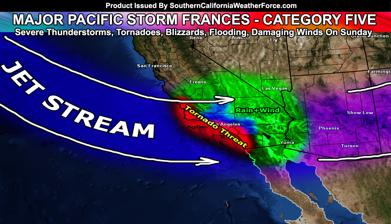
A quick hitting potent storm system is set to impact on Sunday. Major Pacific Storm Frances is a category five system at the center and the dynamics for Category Five will affect the metro areas of the forecast region. This system will hit the San Luis Obispo/Vandenberg/Santa Barbara/Kern Zones on Sunday morning, flushing eastward through the VT/LA/OC/SD/IE and surrounding zones later in the day. This will bring heavy rainfall with it. Rainfall will extend into all desert areas due to the deeper-layer moisture well above 25,000 FT.
At the surface, a potent surface low deepening to below 1000mb over Las Vegas would up the wind gust potential along the initial storm front. The wind gusts with this could realistically hit between 50-70 mph along the front so this has to be watched very carefully. Strong southerly flow like this is the first ingredient for severe thunderstorms in the metro areas. The next one is upper divergence … and we have a lot of this. The next is instability and due to the timing of the day this hits … plenty will be available. The last one is directional shear. Much like Major Pacific Storm Eugene had, the strong southerly low level flow will be accompanied by a south westerly flow in the upper levels. This is telling me that the front will have discrete supercell potential with it and plenty of upper level exhaust will be available for tornado potential yet again. The need of a tornado watch is increasing …
The snow level with this along the front will be high, on the order of over 7,000 FT so above that level is where the blizzard conditions will be met through the entire front. Point being, the warm air advection into the front will bring mostly rainfall to the mountain communities and ‘lower’ resort levels for the majority of the front. The snow level drops below 5,000 FT by evening/night after the front and any left-over showers would be snow at that level … so we’re seeing a scenario that starts out as rain for most of the mountain resort/community areas and then ends as snow … something pretty typical with advection fronts. Blizzard Watches/Warnings would be needed for areas 6,000 FT and above … with snow showers hanging onto the Gorman and Kern County Mountains through the entire night behind the front with gusty northwest winds developing.
Light showers will start in the Vandenberg, San Luis Obispo County, and Kern zones as early as Saturday … out ahead of the main storm front the following day.
Through today, alerts for marine, flood, wind, and snow will go out for members. If you are not a member, consider subscribing to these micro-climate alerts … it pushes the pinpointing of this site for your area to maximum … Click Here To Read More