 A high risk fire season that may last over four months starting this month is expected across Southern California due to unfavorable monsoon ridge placement. Read on for details.
Fires are breaking out in parts of Southern California, notably in Temecula and the Calabasas/West Hills areas. These fires are due to the extremely hot temperatures across the region, forcing records to continue to fall. High temperatures of over 105F degrees have been reported in parts of the Inland Empire, with well over 115F or higher in the lower deserts, including the Coachalla Valley.
The following are our model’s projections for Sunday, Monday, Tuesday and Wednesday high temperatures for selected cities; showing a decline in the metros with continued heat for the Bakersfield Valley and Desert areas …
Riverside: 94 – 89 – 88 – 91
Indio: 105 – 106 – 105 – 103
Barstow: 103 – 102 – 106 – 107
Lancaster: 93 – 95 – 96 – 95
Bakersfield: 105 – 105 – 107 – 103
Valencia: 91 – 89 – 89 – 87
Los Angeles: 76 – 77 – 81 – 78
Brawley: 115 – 112 – 110 – 109
Blythe: 115 – 111 – 109 – 109
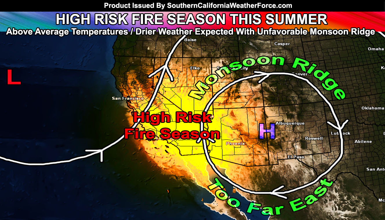
Monsoon season starts officially on June 15, 2016 and unfortunately there is some bad news for Southern California. If my projections are correct as they were for calling for the bulk of the storm train into Northern California when ‘others’ said Southern California for El Nino … the season will fail to produce an above average rainfall season like last year. This fail would be due to the ridge placement for most of the Summer.
The ridge would be over the AZ/NM border when established … and this type of pattern would bring a dry southerly flow into the region, with a trough carved well west of here for a southwest flow. Most of the impulses would miss Southern California. Last year, the ridge formed north of here over Salt Lake City and Central Nevada, which had a moist and quick easterly flow into the area. Evidence in the flow this month and last month suggests that a setup for unfavorable conditions for impulses to hit our region isw the best option at this point.
The worst case scenario is an above average summer for temperatures and drier than average. The Southern California fire season will not start with Santa Ana Winds this Fall… it’ll start this Summer and run right into a very active Santa Ana Wind Fire Season this Fall.
Over the next few months, those in fire prone zones will need to take your precautions, clear brush around your property … and have a plan in place in-case your area has fires.
How Can We Get Storms?: The only way to get a surge of tropical moisture for rainfall would be an active Pacific Hurricane Season. El Nino typically favors this in the Pacific Ocean, La Nina does not. We are fast gliding toward a La Nina and this would put the basin at equal chances. Give a ridge to the east of here and a trough to the west … a fast developing south-southwest flow could bring a tropical system near the area this Summer … however one has to be strong enough to make it near here and this would be a bit rare in a neutral Summer (neither El Nino or La Nina) …
Stay tuned to Southern California Weather Force for additional updates …