The official 2016-2017 Forecast is in … and it is a good one, with many blocking features to support flooding, severe thunderstorms, low elevation snowfall, and damaging winds, with one of my analogs including the ARK-STORM pattern we had in California in the 1800s. Read on for all those details.
PAST ANALOGS INCLUDE ARK-STORM PATTERN
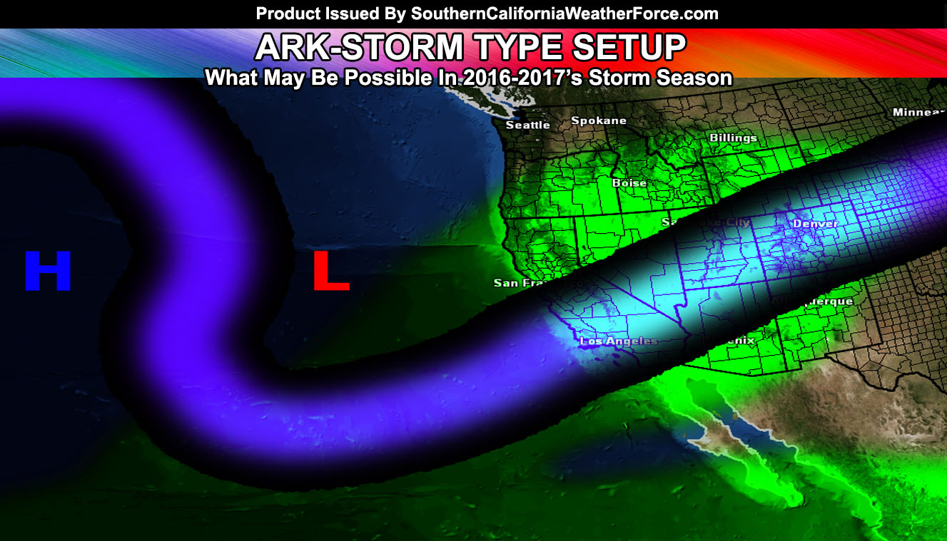
Believe me when I tell you this … You are only believing the same people whom said El Nino would flood everyone out and since they were wrong is this really the thing to believe right now? The pattern indicates long range ARK-storm type systems into California. Confidence is rising that the pattern between March and now is that of the year 2004 … the only analog pattern for such. That season had many blocking patterns, including low level snow in the Inland Empire areas .. .and numerous storm systems throughout the entire season … It seemed like it had La Nina type patterns and El Nino at times.
An undisclosed theory of mine is leading me to believe that the 2016-2017 storm season will yield more rainfall in Southern California than the previous Super El Nino. The theory revolves around the general position of the ridge average in Spring and Summer … lasting 6 months. Using a mathematical equation it can be predicted where the large scale patterns will be in the Fall and Winter … prime months for rainfall in Southern California.
We raised a lot of help from the public for this season,
CLICK HERE to view how YOU can help – https://www.gofundme.com/2s7yxz8
During December 1861 to January 1862 the state of California received numerous Pineapple Express systems, which lead to the ‘Great Floods of 1862’. These floods were NOT associated with an El Nino. So that pretty much sums it up that El Nino does not need to be present for major storm systems to hit California. What likely happened is a blocking pattern formed with a large ridge way west of North American … that brought low pressure systems on the east side of it due west of the coast and stayed there … pumping in moisture for many days. This type of event is only possible during a neutral or La Nina pattern where the atmosphere has strong ridges. Where those ridges generally end up is unfavorable for Southern California in La Nina but there is always the chance they push to more favorable positions.
So .. just like the failed Super El Nino … a La Nina can easily put down many storms regardless. There are more pieces to the puzzle here.
LIKING WHAT YOU ARE READING? –
JOIN OUR FACEBOOK PAGE CLICK HERE
Remember, JPL/NASA Climatologist Bill Patzert said that the people in Southern California would need a boat to go down the streets after this last El Nino was done. I called him out saying Northern California would see more than Southern and it ended up being the correct call. This year I bet everything every single weather person out there will go drier and colder than average simply because it will be a La Nina. I may very well be the only one leaning towards the wetter pattern.
Confidence has risen to critical that the pattern between March and now is that of the year 2004 … the only analog pattern for such. That season had many blocking patterns, including low level snow in the Inland Empire and High Desert areas .. .and numerous storm systems throughout the entire season … It seemed like it had La Nina type patterns and El Nino at times. It truly was an interesting setup and for this analog to come up for the preliminary outlook is a good thing we need to keep up.
WHAT TO EXPECT NOW …
We have seen areas of rain and thunderstorms early this season this month and this is right in-line to my previous thoughts. We are climbing in rainfall averages and November will be above average as well as into some of December.
In November 2004 we did have an inside slider out of Canada that brought low elevation snow to the Inland Empire and High Desert areas.
This season looks like it’ll happen again and this may happen around the same time … Between Mid November and Mid December.
Given that we have a weak to moderate La Nina, blocking is going to be the main developer this season. Blocking means that a ridge will form way west of here and storms would goj up and over it, and down into the Western United States. Where these end up will determine our weather pattern, however given the blocking we have seen this season … confidence has peaked that steady blocking for storms west of here would favor California into above average rainfall and storms.
Unlike last season where San Diego saw more rain than Los Angeles, Los Angeles will see more this time. San Diego sees more rain when storms miss to the north and provide stronger west to east winds in the low levels. However, majority of the storms this season will produce southwest to northeast low level winds, even south to north … which does mean that Los Angeles will be favored more than San Diego … which is quite rare and happens maybe once every 5 years.