Major Pacific Storm Hillary is on the door-step of Southern California and moving in fast with a peak overnight tonight into Thursday morning and I’ve issued the Tornado Watch product your forecast starts now.
Major Pacific Storm Hillary is a category five Pacific Storm on my one through six scale (link to explanation). She’ll start off with showers moving through most of the area as early as this evening out ahead of the cold front … so this would be the warm front. Because of the drier air in the low levels, The mountains wil have lower snow levels, but the temperature in the evening with the passage of this precipitation will be above freezing. Pretty interesting actually so we’ll see if that verifies.
Snow level charts in the member section for Big Bear Lake shows the snow level rising out ahead of the main cold front Thursday morning. This is due to warm air advecting in from the south with a median snow-level of 5,500 FT. Charts here reflect very little snowfall for the main front for Pine Mountain Club and Tehachapi so not much is expected there. However, due to the strong frontal zone winds, heavy snowfall, and white-out conditions, I’ve issued the Blizzard Warning for the Ventura, Los Angeles, San Bernardino and Riverside Mountains mainly above 5,500 to 6,000 FT for your Thursday morning.
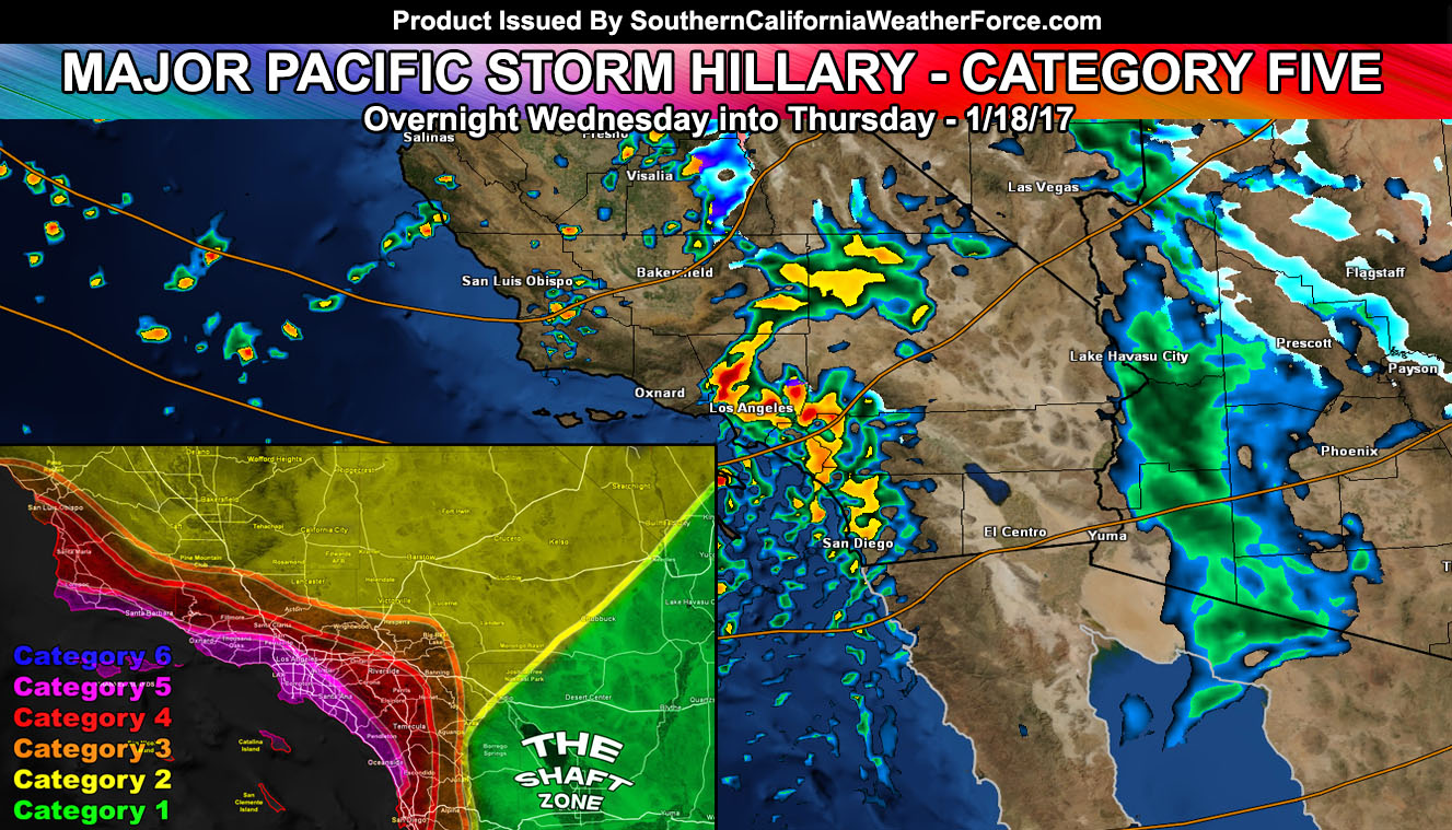
In addition to that, I’ve gone with a Tornado Watch for all metro areas of the forecast region. The best chance is Thursday morning along the coast and 10 miles Inland with isolated risks as far east as the Inland Empire.
At the surface; expecting a strong southeasterly surface flow across the watch area overnight tonight into Thursday morning. This southeast flow will work with a west to east flow in the mid-levels and produce the needed low level spin in the atmosphere for rising tornado probabilities. In addition to the tornado risk, some hail , lightning, and wind gusts over 50+ mph will be possible with this.
The system will remain severe through the Inland Empire areas … with a dragging front of broken low-topped supercells and gusty winds into Santa Clarita Valley and DOwntown San Diego … The center of the tornado risk will be along the coast and 10 miles inland …
The storm will give high waves to the coastal region through early next week with a strong westerly swell … upwards of 12 to 15 FT expected with beach erosion.
Nominal gusty desert winds are in the forecast as well … you’re use to those.
And two more systems coming through, one on Friday and the other on Monday …
So there you have it, Pacific Storm Hillary is forecast to be a category five on my 1-6 system with a strong front, gusty/damaging winds, and the risk of tornadoes and thunderstorms … stay tuned to Southern California Weather Force.com
Not on our Facebook Page? Join thousands for updates.
Click Here To Join
Everyone else is going to have to click the link and go to your micro-climate section and await the alerts that come. Some are out now … and others will be issued.
Click Here To Go To Your Micro-Climate Section –
Full Members can see the snow level, snow amount, flood risk, rainfall maps and much more before events hit … Don’t miss out! … Click Here To Enter the Member Section
See ALL the alerts I issue here – https://www.southerncaliforniaweatherforce.com/