A long duration heatwave that has gripped Inland Southern California will have one more shot for the metros tomorrow and then finally get out of here. A major fire has broke out near the Santa Clarita Valley areas along Highway 14 and relief is on the way after Monday so read on for details.
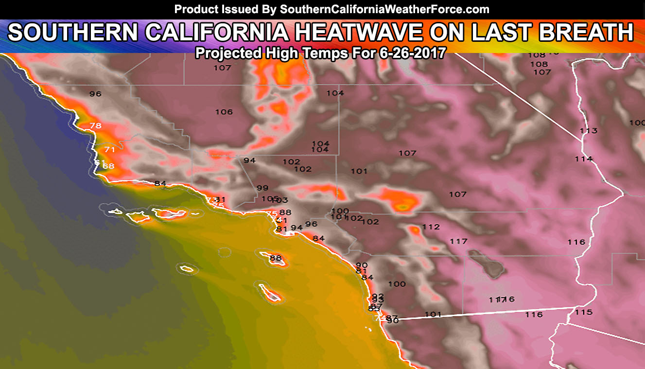
This inland heatwave has mainly been for the metro areas north and east of the Los Angeles Basin areas, with many areas near the coast, downtown, and a few miles from the coasts enjoying pleasant weather. Some parameters suggests that the spread of 90s will come toward the coast on your Monday more so than any part of this heatwave. Downtown LA could get to 90F on Monday, with some areas along I-15 in San Diego County seeing near the triple digit marks as well. San Diego Airport will likely be in the 85-89F range so still a bit warm for that area in terms of the averages.
Monday will come out with 100s inland once again and the nominal high/low desert/Kern Valley summer temperatures as well.
The Placerita Fire is burning along Highway 14 between Santa Clarita and Acton … in dangerous areas. The plan is to push it to the Sand Fire burn scar area so that it has no more fuels to feed off of.
Look at the next 24 hours it appears that 10-15 mph winds on average moving along Highway 14 from Santa Clarita to Acton will continue with this fire on an east-northeast movement, which is in line to threaten the homes along Highway 14.
If you are in Santa Clarita proper along I-5 you will not be affected by this fire as Santa Ana Winds or strong offshore flow is not expected. However, if you are between the fire and Acton you need to be alert and continue to monitor all official notices that departments will be releasing.
During the night, winds will relax and movement should cease from where it will be going today … with some indications of a reverse weak flow after midnight until sunrise … so strong winds will not be an issue with efforts on fighting this blaze.
LIKE ME ON FACEBOOK for updates! Click Here and join thousands …
One thing to keep in mind is the onshore flow becoming stronger on Monday afternoon/evening. 20 mph winds will make the fire return to a east-northeast travel along Highway 14, in the same direction it is going today. It’ll remain hot as we near the end, but very sharp high temperature contrast heatwave … with cooler weather returning by mid-end week below heatwave warning levels.
FOLLOW ME ON TWITTER: Click Here To Join
General wind patterns for smoke plume motion will be to Acton through the next 24 hours, with a north flow to the Antelope Valley, which could make Air Quality issues in the Acton, Lancaster, and Palmdale forecast zones. Issues on Air Quality will be addressed shortly for you.
SCWF AIR QUALITY WARNING ISSUED:
Click to read warning alert information
Cooler weather is on the way after Tuesday and hits are that Independence Day remains to look like a nice day for most, temperature-wise for outdoor activities …
THE NEXT HEATWAVE IS EXPECTED JULY 6TH ONWARDS … Enjoy this cool-down while it lasts … This summer is going to continue to be brutal …
Click The Link To Read More about the Summer 2017 Forecast: The 2017 U.S. Southwest Monsoon Season Has Officially Started; Details