I have finished my medium to long range forecast for the Great American Total Solar Eclipse, crossing the entire United States on August 21, 2017. Whether you’ll be away on business, school, camping, or traveling to … this detailed forecast will help you know your best chances so read on for your forecast zone outlook.
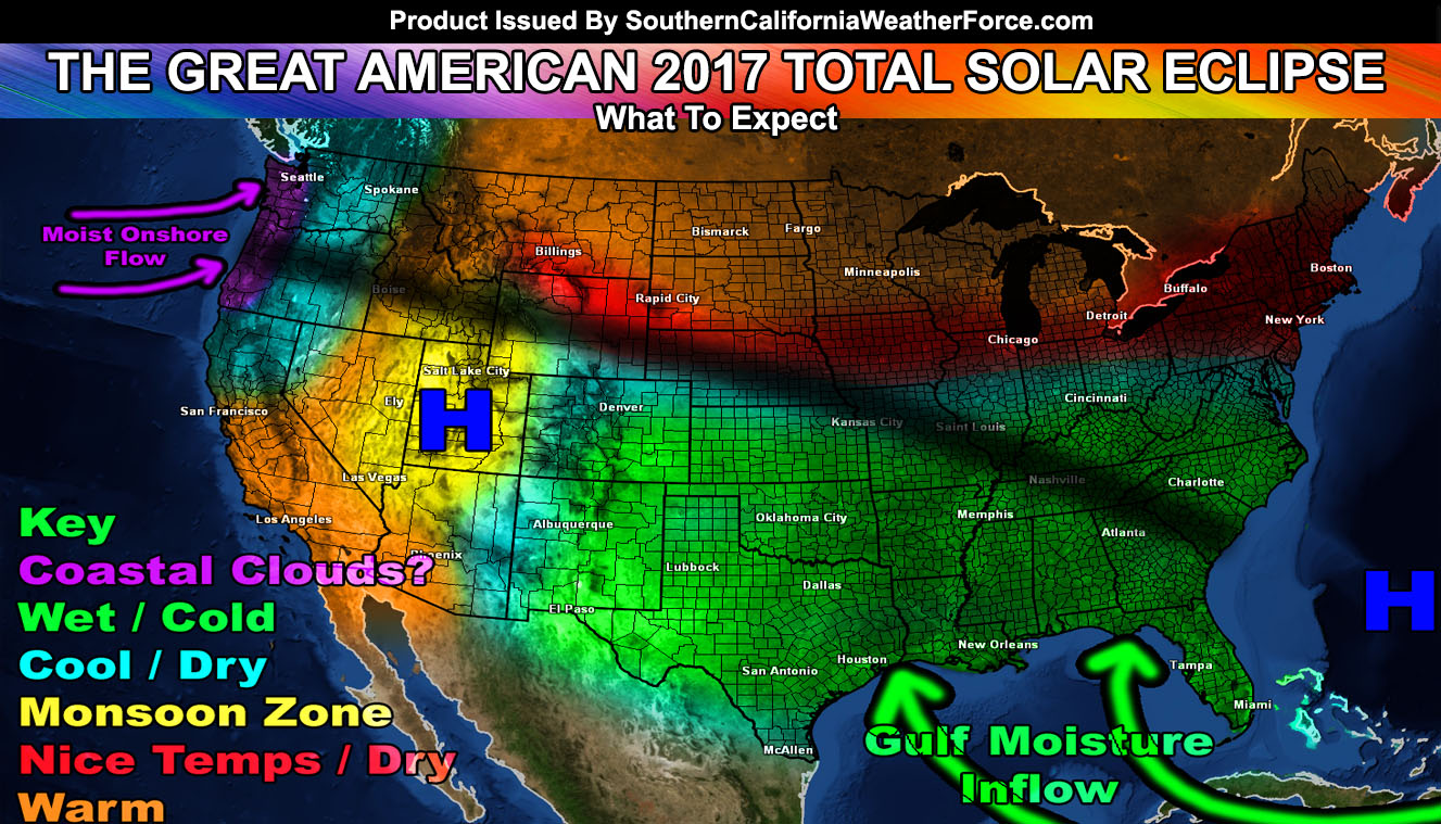
Coastal Clouds: In looking at the map the first thing you’ll see in the key is Coastal Clouds. Being I do foresee a ridge of high pressure over the Utah areas, a trough would establish west of the Oregon and Washington areas. Along the path of totality across Oregon they’ll be a southwest to northeast onshore flow. This means that the risk of low clouds (morning) and fog will be possible there west of the Cascade Range.
LIKE ME ON FACEBOOK for updates! Click Here and join thousands …
Wet / Cool: The next in line is the cool and wet zones. This eclipse happens in the afternoon for the most part in this shaded area. The monsoon will be well underway in New Mexico for storms there, and a high pressure system east of Florida will usher in moisture from the Gulf of Mexico over a large area of the Southeastern United States for thunderstorm risks. Since it is in the afternoon … the risk of developing shower and thunderstorm activity in these regions is high. You best chance will be hoping you aren’t over one of these cells when it develops.
Cool / Dry: The placement of the ridge of high pressure over Utah would make for a lower risk monsoonal flow over much of Arizona and Northern Colorado. While not in the path of totality, being it will be in the morning, the lack of convection over the area would make for great viewing. However in the path of totality is Oregon, east of the Cascades. While low clouds and fog could be a problem west of The Cascade Range, the range will block any of these and the result would be cool and clear conditions in Oregon’s desert zones. The other area lies across Nebraska and Northern Missouri … so expecting the storm flow (further north) not to be an interacting problem.
Monsoon Zone: The ridge of high pressure will bring the monsoonal activity through Utah and Nevada, possibly even up into the Idaho Falls, ID areas. However, as previously mentioned … activity in the morning is not as convective (clouds forming) as it is in the later afternoon hours. So this area; while it may have the monsoonal storm risk, remains in a good spot for the viewing, especially across the path of totality. If you get a mountain range to your south in this area, you could get some growing clouds in the way. The best way to handle this is have a mountain range to your west or north … preventing storms forming over the mountains from blocking your southeast to south view of the eclipse.
Nice Temp / Dry: This zone is just south of the storm track and expected upper level jet stream. This zone is considered a neutral (not too hot not too cold) temperature zone and drier than usual storm chances. Areas in this for totality will be Wyoming and Nebraska.
Warm: Self explanatory. This area will have warmer than usual temperatures … and drier conditions for Idaho with equal chances of precipitation across the Northern Plains of the USA … nearest the storm track.
So there you have it … Whether you’re traveling to the totality zone or staying in your area … this map forecast is the most comprehensive forecast for the coming event.
Click Here To Find Your Zone On Facebook For Updates Now and In The Future