A weak cold front is scheduled to come into Southern California this week, promoting a cool-down relief. Read on for details.
In last night’s article I mentioned issuing my Weather Advisory. This advisory was for shower/thunderstorm activity for the Inland Empire into the High Deserts and Kern County through the morning and day today. This seemed to have hit with reports of thunderstorms across Riverside, Fontana and points northwest into the rest of the advisory zone … along with showers in Temecula and up the 15 toward Corona and Norco. This has sense expired in the metros.
LIKE ME ON FACEBOOK for updates! Click Here and join thousands …
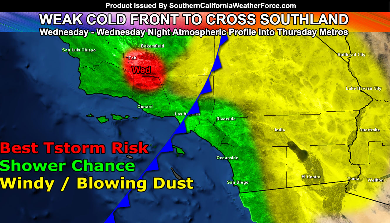
Now what about the rest of the week? Well the marine layer is returning to the coast tonight into the morning on your Tuesday, starting the cool-down process with returning onshore flow. By Wednesday night into Thursday we get a weak cold front moving into the forecast area and this is what will cause a drastic cool-down .. .along with the chance of light showers in our metro zones finally. Fronts like this cause less precipitation for San Luis Obispo than areas in LA/OC/IE/SD due to the terrain influence.
I could almost say this is our first actual weak cold front of the season, which starts on September 15th. The coldest days will be Thursday and Friday, with well below normal temperatures region-wide and cloudy conditions with clouds failing to depart the area so sunshine in the metros and coastal zones will be limited to nil… especially on Thursday, something you’ll all enjoy.
Click Here To Find Your Zone On Facebook For Updates Now and In The Future
Click Here To Find Me On TWITTER.
VISIT THE MEMBER SECTION FOR 2017-2018 SEASON – SIGN-UP OR READ ABOUT IT HERE
Because of the weak cold front dynamics, gusty mountain and desert winds will return out of the west after Wednesday and you are highly use to that in those areas.
Thunderstorms are possible with the core of the system on Wednesday, which could easily be over Pine Mountain Club or somewhere in Kern County. More info will be given in the coming day or so.
It won’t last too long as we get into 90F inland by the weekend, however the sun angle is starting to go further south and the only way we’ll get to 100s again is with a Santa Ana Wind Event in October. After Halloween we are guaranteed to be cool …