A major heatwave is scheduled to hit the area after the weekend with an offshore flow pattern. We’ll see brief cooler weather before that and even the chance of thunderstorms in the northwest forecast area. The International Space Station is making a flyby this evening. Get all the complete details by reading on … pay attention to the zones discussed for today …
We’ll start with the closer event and that is the west and northern forecast areas having the risk of thunderstorms today that can contain the ingredients for dry lightning, starting more fires. The most likely zones for this to cross today through tonight will be starting on the San Luis Obispo’s southern coast to Vandenberg Air Force Base. The batch will transverse the area going eastward into Kern County and into the Barstow and Fort Irwin forecast zones before exiting over Las Vegas tomorrow.
LIKE US ON FACEBOOK for updates! Click Here and join thousands …
The next event in this schedule will be the International Space Station. It is set to fly over the Southern California area between 6:34pm and 6:39pm this evening (10/17), peaking overhead the Inland Empire zones by 6:38pm. This pass may be met with high clouds so it may not be completely clear for some of you. However, the pass is a 90 degree angle directly over Corona (The Southern California Weather Force Office) at 6:38pm and it isn’t something you want to miss. Look for a very bright pinpoint of light moving from northwest to southeast during the window. A countdown clock below is available for this event.
International Space Station Overhead Countdown Clock (Southern California)
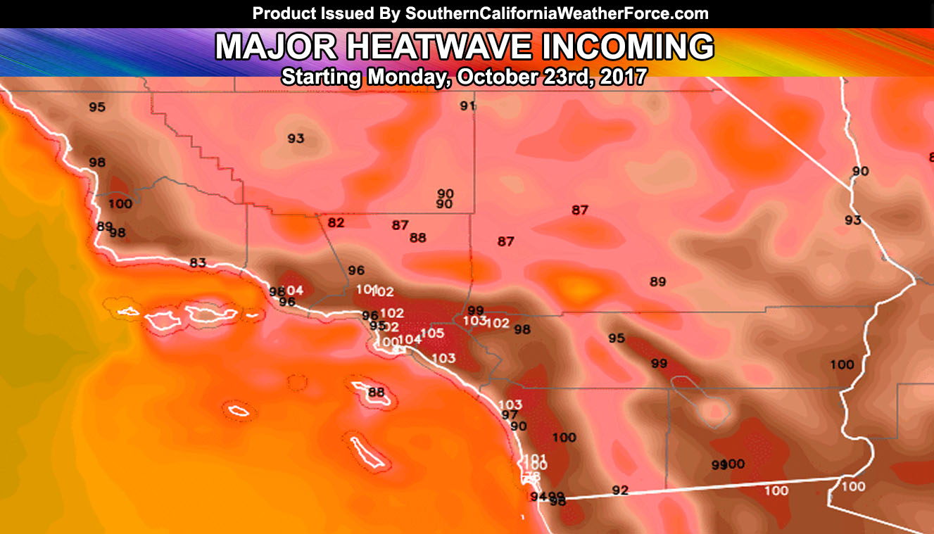
The next event is the cool-down and heatwave. Sure it has been hot for October but that is nothing compared to what will be felt this next week. As we approach end week an onshore flow will move on in, in response to an upper trough. This would bring back the low clouds and fog and push the temperatures below average, giving a taste of Fall. This won’t last long as my heat model projects temperatures over 100F-105F or higher in the Inland areas by this next Monday under offshore flow … so Santa Ana Winds will be in this forecast as well.
We need a system to drop into the region by the end of the month or the Typhoon would be ultimately responsible for changing the coming pattern … otherwise known as the Butterfly Effect.
So we aren’t out of the game yet for another wet season … but it certainly looks like it’ll be different from last year’s rainy season and much colder for an average.
Click Here To Find Your Zone On Facebook For Updates Now and In The Future
Click Here To Find Me On TWITTER.
VISIT THE MEMBER SECTION FOR 2017-2018 SEASON – SIGN-UP OR READ ABOUT IT HERE