The temperatures are on the decline, as previously said .. .and we’ll be in the 70s in no time with a seasonal/cool Halloween and declining temperatures even further the first week of November with a shot of rainfall. Read on for details …
Those 100F readings are a thing of the past now as the combination of Pacific troughs and the lowering sun angle brings in seasonal temperatures. So finally, we are done with those Summer-time temperatures. Looking ahead on Halloween we see a chance of precipitation. Most of my models are showing a deep marine layer with low clouds, drizzle/light rain scenario so this isn’t looking like a Pacific storm front.
LIKE ME ON FACEBOOK for updates! Click Here and join thousands …
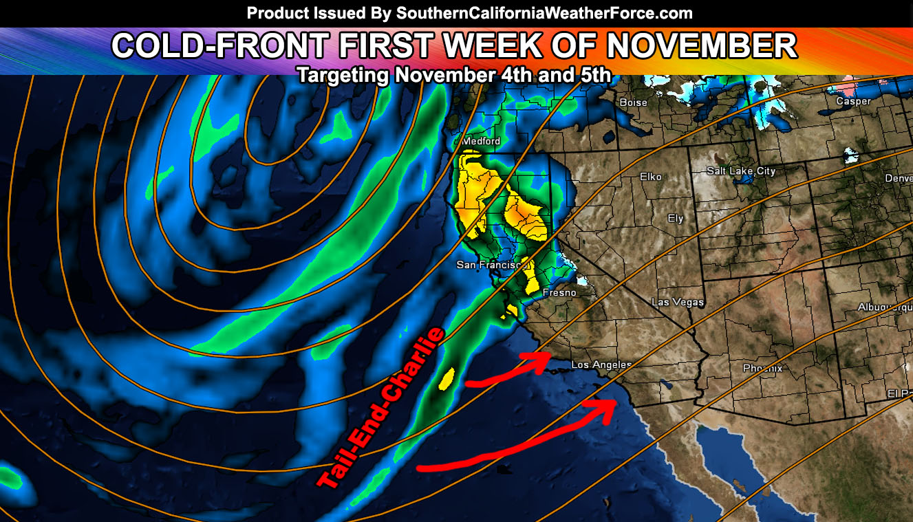
The first week of November will have a Pacific storm front hitting California, more for Northern and less for Southern, which could be the pattern this year. Temperatures in response to the cold fronts will respond with a decline with highs in the 60s for the metros.
HATE THE ADS? Become a premium member and support the service along with other perks …
Click Here To Learn More …
In addition to the cooler temperatures, the 4th and 5th time-frame will have a storm front moving through. It’s looking like a tail end charlie type situation where it will be heavier south and west of the mountains than the deserts and weaken as it moves across the region, the strongest hitting Central and Northern California. Still, my precipitation forecast for this event is at 90% for LA right now in the Weather Event Agreement section of the member section.
More information will be given, but confidence is gaining fast of a cold-front moving through sometime around November 4th and 5th.
NOTE: The storm has a surface low offshore Northern California so this would mean gusty winds along the frontal zone … and gusty winds in the mountain/desert areas as well. Pretty much the strongest winds in the metros will be Los Angeles westward, especially Vandenberg Air Force Base.
The snow levels look rather high at this time due to the southwest flow in the low levels.
Members, follow the precipitation model updates daily in your member section by clicking here –
Click Here To Find Your Zone On Facebook For Updates Now and In The Future
Click Here To Find Me On TWITTER.
VISIT THE MEMBER SECTION FOR 2017-2018 SEASON – SIGN-UP OR READ ABOUT IT HERE