A rare setup this evening will provide the region with a rare sunset opportunity and photographers should snap those pictures at sunset.. Light rain and drizzle is expected through Halloween, and a cold-front finally reaching the area by this next weekend for better rainfall chances in some areas. Read on for details.
A trough moving through the region overnight tonight and into Monday will increase the Catalina Eddy and onshore flow enough for light rain and/or drizzle across the majority of areas south and west of the mountains. This will last through Halloween.
It will be worth to note that a strip of mid/upper level moisture in a narrow band moving across Santa Barbara County now will continue to slowly move eastward and that we may have an rare and interesting sunset over the region tonight. If you live over Ventura, LA, and Kern County it’ll be above you. If you live in the Inland Empire, High Desert, or San Diego look to your west, with San Diegans needing to look northwest towards Los Angeles. Areas in Palm Springs will see it to their west and Imperial to your west-northwest and low on the horizon. The event will have beautiful colors in a narrow looking strip of clouds, which could contain virga, or rain in the mid-levels evaporating before it hits the ground.
LIKE ME ON FACEBOOK for updates! Click Here and join thousands …
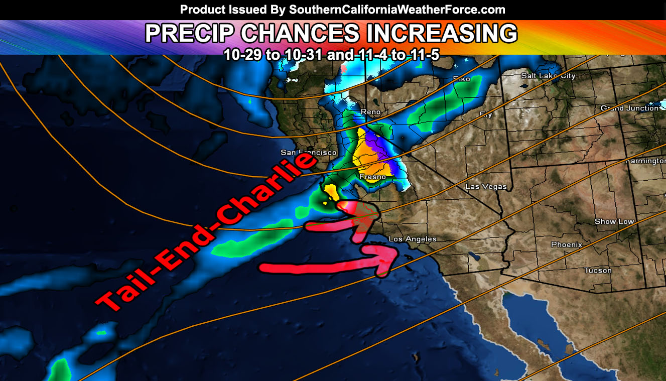
Now, what about that tail-end charlie system? The new product in the member section that is free to view at the moment called the Weather Event Agreement is being updated daily and has been predicting a system around November 4th-5th since October 21st. This new product so far has been a success in confidence levels as this next weekend I believe a storm system will hit California, which will send the southern part of the front into our region. What that means is tail-end charlie fronts give more rain to Los Angeles westward than south and eastward. These are pretty common in the Fall. Only 2 out of my 20 models show 1″ or more in Los Angeles for the November 4th-5th system so I’m thinking this will be a weak storm system at the time for the city, a typical tail-end-charlie type.
HATE THE ADS? Become a premium member and support the service along with other perks …
Click Here To Learn More …
This storm system is not an inside slider so what we’re looking at is higher confidence in good rainfall for the 2017-2018 storm season and my official final forecast for such will be given sometime in November. I’m leaning colder and wetter than average for this storm season and have been for many months.
Members, follow the precipitation model updates daily in your member section by clicking here –
Click Here To Find Your Zone On Facebook For Updates Now and In The Future
Click Here To Find Me On TWITTER.
VISIT THE MEMBER SECTION FOR 2017-2018 SEASON – SIGN-UP OR READ ABOUT IT HERE