This will be your final detailed report of the Hurricane Force Santa Ana Wind Event that is about to impact hard across the prone zones of our region of Southern California along with very cold low desert and Kern temps. Get all the details by reading on.
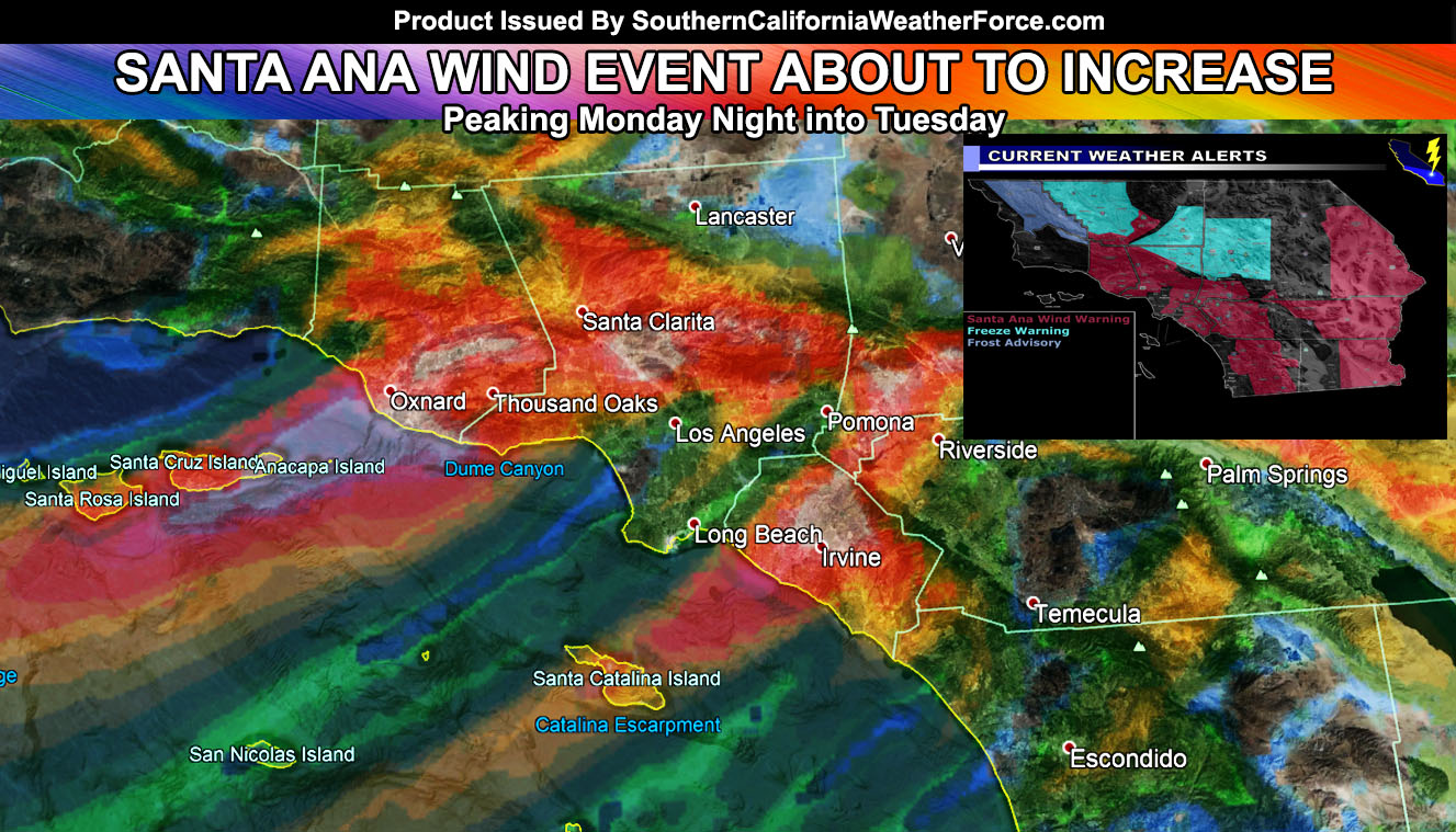
Mostly the nominal prone zones are being impacted today with moderate Santa Ana Winds. This was projected in the previous article as this morning was not the main event. As we gain upper support we will have more of a push off the valleys and into the prone coastal zones as well, including Orange County.
LIKE ME ON FACEBOOK for updates! Click Here and join thousands …
The reason for the lack of spread from the passes and canyons thus far is because of something called an inversion. The inversion layer is around 3,000 to 4,000 FT up and the main wind gusts are still stuck up there, with some leaking down. It’s a layer of warmer air above the cooler air down here. Once evening comes on this Monday, this inversion layer will break, allowing for wind gusts to become stronger in all Santa Ana Wind Prone zones, excluding San Diego County. You’ll have to wait till Tuesday for Escondido when the wind switches to east to west instead of northeast to southwest. This means that during this evening into Tuesday morning will be the main event, including some Orange County Coastal regions.
Santa Ana Wind Gust model clearly shows the real chance that John Wayne Airport could near the 50 mph gust mark straight into Costa Mesa, in Orange County. This is pretty rare, but when an inversion breaks in such a dynamic way it usually happens … so I’m betting on it overnight tonight into Tuesday morning.
As such, this evening we’ll see rare areas open up such as Glendora and Azuza with 40 to 50 mph wind gusts through the night .. spreading 30-40 mph wind gusts into the Central/Eastern LA Basin from there into Whittier.
HATE THE ADS? Become a premium member and support the service along with other perks …
Click Here To Learn More …
The strongest metro area winds overnight tonight and into Tuesday morning will be Moorpark (Ventura County) with 65 to 75 mph wind gusts … and Victoria Gardens Mall, along Interstate 15 near the base of the Cajon Pass at the same as Moorpark.
No doubt there will be lost decorations if you didn’t heed my warnings days ago or even last night… or even now … but I’m always up for free decorations here. I’m in a valley on a hill with houses above me in the northeast direction … so within range for free blow up decorations to rain down on me tonight if they are not secure … maybe even score a trampoline … I can only hope…
The winds will stay gusty in Santa Ana Wind Prone Zones through Tuesday… some on Wednesday, and by Wednesday night into Thursday morning it is possible another strong round will hit, this time having an easterly component that will be good enough to bring the gusty winds to the San Diego areas, along I-15 off the San Diego County Mountains … that’s your chance there …
What about temperatures? Well … temperatures last night were cold in the high desert.. .but not as predicted by ‘other’ services. Tonight however will be a different story. A widespread freeze will be likely … going to go with a 25F to 29F low temperature freeze for the entire Victor Valley Metro areas up the hill … Edwards Air Force Base … Lancaster … and Lucerne Valley areas through your Tuesday morning, and this would be a Freeze Warning from me … which I’ll make official on your micro-climate pages in a couple hours. Some areas within Joshua Tree along Highway 62 will see freezing temperatures as well where wind is not present.
The Bakersfield Valley will see 30-35F temperatures, the coldest will be in Buttonwillow and Wasco. No wind is expected.
Temperature grids are in the 40s along the CO River Valley so this is telling me that you have the gusty winds as well … a reason you were included in that Santa Ana Wind Warning …
Stay bundled up .. get those decorations tied … stay safe .. .and stay tuned to Southern California Weather Force
NOTE: Members, You can go to the member section by CLICKING HERE and finding the wind model here at SCWF for the peak event.
Click Here To Find Your Zone On Facebook For Updates Now and In The Future
Click Here To Find Me On TWITTER.