As I stated in yesterday’s article, a restart of the damaging Santa Ana Winds will happen tonight into Thursday morning, which will be more widespread from Ventura to San Diego County than earlier this week. Read on for details …
There’s somewhat of a lull today, and that was expected. However, starting this evening and through the overnight winds will increase in gusts across the same areas that saw them this week. So… if you saw them this week then you can expect to see them again with the next burst.
Before we begin, if you live in the Santa Clarita Valley, I’ve created a new micro-climate group. Click Here To Join – The rest of you look at the end of this for the link yo go yo yours.
There are things I am looking at right now that are a bit bothersome. The one major thing I am seeing is Ontario Airport gusting right now to 40 mph already. This is telling me that model development with this event may be under-done and that area is only suppose to be gusting to 25 mph today. Given that, it seems I will need to adjust the model values to match it so what the 60 mph value tonight says for an area, I’ll need to make it 80 mph. This will make the forecast hard, however I can push through it.
If it does not say “Liked” LIKE The Page Below and join thousands of informed weather forecast viewers in our region for more of the updates!
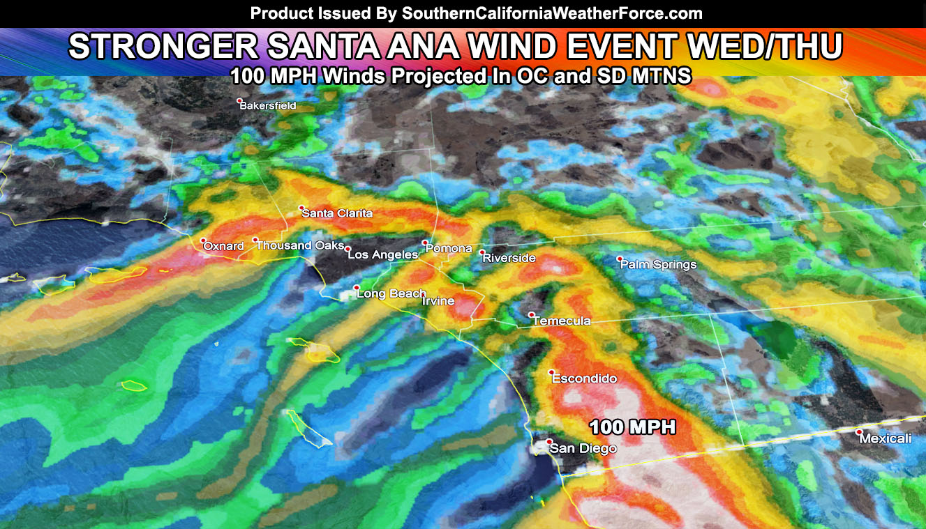
Areas that did not see the Santa Ana Winds such as Hemet and San Jacinto … and much of the San Diego County areas … will see this event this time. The reason for the lack of last time was like I stated in previous articles. We had more of a north-northeast flow, which isn’t a good flow to get gusty winds in those zones. To get gusty winds in those zones you’ll need an east to west flow over the local mountains and racing down the foothills into the valley areas. This such pattern happens by Thursday morning in those areas. Temperature map in the Low Temperature Model section on the website’s member section shows a 50F temperature mark over Hemet by Thursday at sunrise. This morning however it showed Hemet in the 30s. What this means clearly is that Hemet will be getting the Santa Ana Winds on Thursday morning, with compressional warming ..so that is something to monitor.
Peak wind gusts for this event may be the strongest of the season. If you thought earlier this week was strong, some areas will be two times stronger. The strongest wind gusts will be measured at 80 to even topping 100 mph in the San Diego County Mountains, and possibly in the Santa Ana Mountains.
HATE THE ADS or Love the Forecasts and Want To Support The Work To Help it Stay? Become a premium member and support the service and receive forecast perks as well …
Click Here To Learn More …
Short range models show 50kt wind gusts at 2,500 FT across the entire region. Now in order for those to surface we’ll need the inversion layer to break like it did earlier this week .. however I do not think that will be a problem at all. This is actually much faster than earlier this week.
So in a nutshell I’m going to go with the above and that this event will be stronger than the last.
I do believe that ALL my models are underestimating this next event and that where 40 mph is will turn out to be 60 mph … and that we will see on a weather sensor in the Santa Ana Mountains or the San Diego County Mountain having 100 mph wind gust readings.
I do not predict fires … however I can tell you that downed power-lines are the number one cause of them in rural areas. Everyone in the Riverside and San Diego County Mountains need to be on the lookout for smoke with this event.. including the Hemet areas …and… let’s go with the Orange County Santa Ana Mountains as well … Not having a good feeling about San Diego County with this next event as it could turn into what we are seeing in Ventura County.
Freezing Temperatures will remain in the San Luis Obispo Valley zones and High Desert regions. There is an interesting chance that the Brawley / El Centro zones may have an Upper 30s reading for a low by Thursday morning … so you’re not use to that right now.
Heading to Vegas? Well.. By Thursday morning temperatures will be in the 30s on the strip … bundle up!
FIRE DIRECTION INFORMATION:
Ventura and LA County – Direction today will be southwest, tomorrow west-southwest.
Orange and San Diego County, including Hemet – Direction today will be southwest, tomorrow due west.
Stay tuned to Southern California Weather Force for any additional updates
Click Here To Find Your Zone On Facebook For Updates Now and In The Future