[vc_row][vc_column][vc_column_text]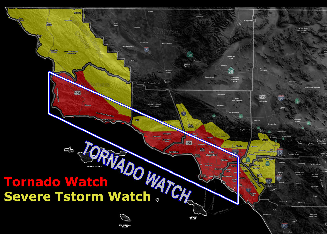 [/vc_column_text][vc_column_text]Issued Zones: San Luis Obispo … Santa Barbara, Ventura, Los Angeles, Orange County … Western Inland Empire …
Site: Southern California Weather Force has issued a Tornado and Severe Thunderstorm Watch combo alert effective Tuesday … Read on for you area …
Date: 1/8/18 at 8:50pm PT
Forecast: The Tornado Watch has been issued for the Santa Barbara, Ventura, Los Angeles, and Orange County coastal zones and 15 miles inland. In Major Pacific Storm NIKITA is heading toward the region at a very fast pace and will be in the area early Tuesday morning before sunrise for areas west of Los Angeles and around sunrise for Los Angeles and OC.
In the upper levels there is a sharp and potent upper divergent lifting area that will be responsible for powerful lines in the watch zone. There are ‘some’ indications that the southerly point of this complex may just be a squall-line …
At the surface, strong backing winds already increasing now in the watch zone is being noted and this backing flow with instability present along the lifting zones ahead and along the front will be responsible for the risk of tornadoes. In addition to the tornado watch I am expecting damaging wind gusts, torrential downpours, and hazardous conditions. A more potent dynamic for tornadoes happens Tuesday afternoon over Los Angeles County, likely in the Long Beach to Monrovia convergence zones. The watch will remain till Tuesday evening for this complex.
It is likely trees will go down and possibly some residential and commercial damage.
As for the severe thunderstorm watch. This watch is for when tornado dynamics are no longer expected as the front moves inland from the 15 mile mark and deeper into the valley metro zones, extending to the Western Inland Empire Ontario/Corona sections, Santa Clarita Valley, Upper Ventura Valleys, and of course earlier on the San Luis Obispo County zones where damaging winds are expected on this line of storms early Tuesday morning before sunrise.
10 mile rule: These alerts issued on this site means that within your zone and 10 miles from you will see the event forecast for. You may or may not see the event but it means you are in the zone or 10 miles from where someone will.
Forecaster: KM[/vc_column_text][/vc_column][/vc_row][vc_row][vc_column][vc_column_text]
If this doesn\’t say “you like this” below then click the LIKE button if you thought this was good information! This helps spread the word by just ONE LIKE … Do it every time if you enjoy these … Thanks for helping!
[/vc_column_text][vc_facebook type=”button_count”][/vc_column][/vc_row][vc_row][vc_column][/vc_column][/vc_row]