Many have been wondering where the cold air of winter was and as I stated last November we would see it by now into March, mainly our spring-time systems. Such air-masses are starting to line-up, the first hitting Sunday night into Monday in what is officially the Martin Weather Pattern of February 2018 so read on for details.
Why is it called the Martin Weather Pattern of February 2018? Well… named like a comet from the discoverer … a long range forecast I put out that no one else does is named after my last name, therefore the discoverer of it. I can go for months with naming through March 2018 at this rate but you get the idea.
Before I get on with the storm pattern I will recognize the large Earthquake yesterday in Mexico. Values have gone back into the unstable color on my fault-stress model which would indicate another Earthquake Watch window starting this morning through the end of the week for a M4.0 or higher in California.
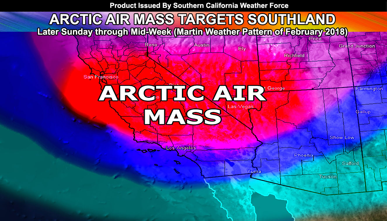
Finally.. the ridge has broken as a result of Pacific Storm Osiris’ altering pattern within the jet and we are now going to start seeing troughs dip further south for our ‘winter-like’ air-masses to finally come in. An air-mass scheduled for later Sunday will come in with gusty winds out of the west for the mountain and desert locations, with almost all areas through then and Monday having gusty cold winds. Southern California Weather Force High Wind Warnings are in place in those areas within the micro-climate alerts in the member section. Up to 80 mph wind gusts are possible on the eastern slopes of the Kern, San Bernardino, Riverside, and San Diego Mountains with average gusts at 45 mph across the warned zones.
Furthermore, we are looking at the risk of snowfall in the mountain zones above 2,500 FT. Because of how low that snow-level is going to be … along with the base of the trough being over the area during this period… I cannot rule out some snowfall making it east of Big Bear into the Morongo Basin to Joshua Tree National Park zones as well as the mountain passes. So if you are a photographer than this is a good opportunity up there. My winter weather watches were issued for the LA/VT/KERN Mountains earlier today, followed by yet another copy from the government weather services watching this site’s forecasts … go figure … The Winter Weather Watch is for snowfall between Sunday evening and Monday night with the chance of several inches at Tehachapi Level and snowfall happening on Gorman. The High Wind Warning included some snowfall wording for the San Bernardino, Riverside, and San Diego Mountains … members can view those products.
If it does not say “Liked” LIKE The Page Below and join thousands of informed weather forecast viewers in our region for more of the updates!
Over the next 12-24 hrs I’ll be introducing the rain/snowfall forecast charts in the member section … so if you are not a member then it would be a good idea to check it out …
What I see after is a very cold air-mass, the coldest being Monday night into Tuesday morning. The cold air-mass will no doubt bring some inland valley areas freezing temperatures with frost a certain … high desert at hard freeze temperatures … and some warnings are on the site now for SLO/KERN Valleys …
The system is rather weak in precipitation in the metros due to the base of the trough moving directly overhead with not much moisture coming in from the west so this is mainly for the cold air-mass that will move over …
Surf on Monday will be up… with 12-15 FT waves being likely on all west facing beaches so be careful out there.
As of now this is what I have and updates will be going out on the page and especially member section before and during the system’s arrival … It will NOT be a named storm…
Long range continues to show no sign of the pesky ridge with colder systems possible as we head toward the end of the month
Click Here To Find Your Zone On Facebook For Updates Now and In The Future
Click Here To Find Me On TWITTER.
This is the end of the public article …
This is now members only and subscriptions can be looked into on the following link – https://www.southerncaliforniaweatherforce.com/system-sign-up/