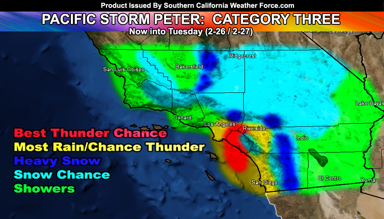
Pacific Storm Peter is a category three system with elevated thunderstorm and rain/snowfall dynamics along with minimal 20-30 mph frontal zone winds. The main front is moving across Santa Barbara at this hour, giving lighter amounts of rain and will move through Ventura County between 7pm and 9pm tonight. The system is expected to strengthen over Los Angeles and Orange County tonight, bringing the risk of heavy rainfall with ‘moderate’ flooding and a chance of thunderstorms extending from there southward into the San Diego zones and also into the Inland Empire areas. I’ve been extremely busy issuing micro-climate alerts for the LA/OC/SD/IE areas.
Before we get into this, check out the member section for the maps if you are a full member. Flood, rain, snow, low temp, and thunder maps are available. You also can go in that section and go to ‘Alerts Issued’ and select your county to go more in-depth.
The system reminds me of the exact track of the early 90s Valentine’s Day storm system. This system dropped down in a similar track and brought a lot of upper lift with it.
Based on what I see, the front will develop the strongest over Whittier into OC around 10pm tonight and shove eastward from there. Still, because the rainfall is expected to be moderate to sometimes heavy on the LA Coast, I’ve included you in this advisory. The front will move across the region tonight.
Because of the upper level divergence, there is a risk of thunderstorms associated with the main front. There are a couple dynamics missing at the moment but if the instability can be overcome by the upper divergence then I don’t see why there won’t be thunderstorms with it. Low level shear is adequate for small spin-ups along it that could mimic small ‘tornadoes’… but the advisory level instability has not been met for a real large concern.
Over the day on Tuesday we will see post-frontal zone convective activity for renewed shower and thunderstorm chances in the area.
The advisory zone tonight will have a snow-level of 4,000 FT, dropping to 1,700 FT by sunrise Tuesday morning and any left-over post-frontal zone activity then could bring flakes to some upper valley locations at and above that snow-level with a mix as far down as 400 FT … The snow level over the day on Tuesday will push up after 9am to 3,000 FT where it will stay for most of the day. Flakes down to 2,000 FT will be possible with a mixing down to 1,500 FT with any activity over the day.
With this, a dusting of snowfall is possible through both fronts in the Santa Ana Mountain Range as well as the Upper Mentone, Highland, and Yucaipa forecast areas.
Snowfall maps here at SCWF show a dusting in Hemet as well, close to Valle Vista and San Jacinto with less the further west you go.
Acton should have a dusting of snow with this event.
I have various winter weather advisory and winter storm warning products issued.
Hesperia will see an inch of snow in southern sections with a dusting in the northern areas. Flakes will be seen in the LA/Kern Desert zones, as well as the Fort Irwin areas, east into the Morongo Basin.
A dusting is likely in the Joshua Tree National Park areas. 2-3 inches will fall just before I-15 and Highway 138 in the Cajon Pass. Other than this, I’ve decided against a Winter Weather Advisory.
The snowfall map in complete can be viewed in the SCWF Member Section.
Other values in the area are;
SBD/RIV/SD
Big Bear Lake – 4″ east end 6″ west end.
Running Springs – 8-12″
Lake Arrowhead – 6-8″
Crestline – 2-4″
Cajon Pass – 2″
Idllywild – 8″
Tram/Round Valley – 2-4″
Anza – 2-4″
Aguanga – Dusting-1″
Warner Springs – 5″
Julian – 12-15″
Live Oak Springs – 5″
Alpine – Dusting
LA
Wrightwood – 4-5″
Acton – Dusting
KERN
Tehachapi – 4″
Bear Valley Springs – 6-8″
Lake Isabella Level – 1″
Glennville – 6″
Pine Mountain Club – 3-5″
Gorman Pass – 1-2″
Overnight tonight we will see back-side moisture through the San Luis Obispo County to Vandenberg AFB zones. Could get some mix/ice/flakes in the Inner SLO regions … but with temperatures expected to be near freezing and with the rain passing you today … this may create a frost problem so plants need to be covered.
I am tracking another system by end week as we move through the second half of the Martin Weather Pattern of February/March 2018
Stay tuned to Southern California Weather Force for the latest official information.