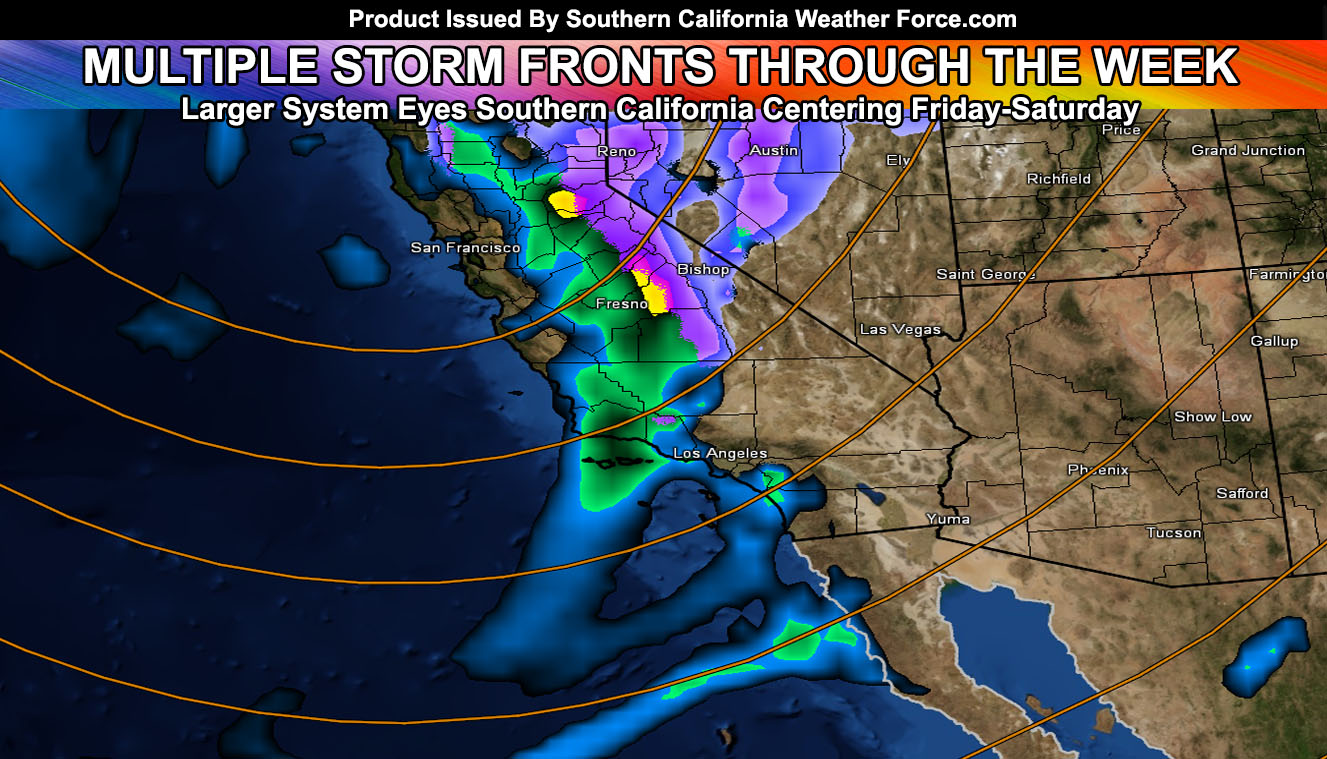
Multiple smaller fronts will hit the forecast area through the week with a colder low elevation snow system looming after the 19th of this month. Various systems are lining up so get the details by reading on …
We are at the start of the Martin Weather Pattern of March 2018. A system giving a glancing blow to the forecast area today will start rainfall across the San Luis Obispo, Santa Barbara, Ventura areas with precipitation. I’ve issued a Flood Watch that is in effect for those zones, mainly for Tuesday. The western edge of a leading warm front will move over those areas starting this afternoon and go through the evening. A brief break will happen and then on Tuesday, probably mainly the morning hours , stretching into some of the early afternoon as well. This one looks stronger with stronger upper level lift and we could see heavy pockets of rainfall from it. A very small section within the flood watch zone will be giving a chance of thunder with it as well. The small section is to be determined at a later time if trends remain the same for the evening numbers. Moderate flood risk is showing up on flood risk maps in the member section, which designates a need for a possible upgrade to Flood Advisory.
If it does not say “Liked” LIKE The Page Below and join thousands of informed weather forecast viewers in our region for more of the updates!
Moving onto Tuesday for the rest of the area. Given this slide over, the front will move through Los Angeles then as well down into Orange County, The Inland Empire, and San Diego County on a weakening trend, likely giving San Diego County’s Foothills better precipitation than most Inland Empire areas for Tuesday/Tuesday night.
A brief break for most of Wednesday and then later Wednesday another front starts in San Luis Obispo / Santa Barbara County and moves eastward through the entire metro zones south and west of the mountains overnight. Will deliver another round of precipitation then.
Near-term is Friday or Friday night.
Most of the deserts remain dry until the end week system, except some rainfall on Tuesday for the LA Deserts coming out of the SCV/SFV.
NASCAR is still up in the air on the three-day event. The Fri-Sat time-frame is more caution than the Sunday one. We may have scattered activity on Sunday however so continue to monitor for the latest forecasts here.
Click Here To Find Your Zone On Facebook For Updates Now and In The Future