By the way things are shaping up, the blasts from the volcano high into the jet stream will produce enough So2 in the local region to maintain or add to a colder than average Summer. Read on for details on the preliminary monsoon effects as well as how you can help SCWF make it through the Summer.
First, before I go into this .. yes I’ve been quiet on my personal profile as I’ll be able to post again on June 2nd. Furthermore we parted with our main summer-time advertiser and will need help from viewers/readers this Summer. So if you are interested in helping you can donate to SCWF in just a couple clicks by CLICKING HERE. I do appreciate all the help to make it through this Summer Monsoon Season.
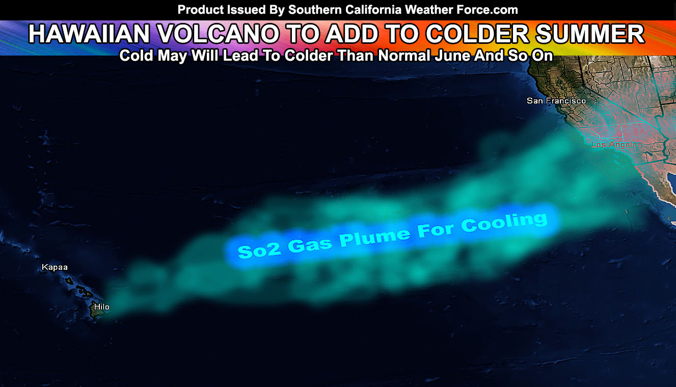
The volcano’s highest plume was around 30,000 Ft. While this is not the 100,000 FT needed to affect the global temperature as an average for a few years like Pinatubo did, it will affect areas downrange of the jet stream along the North American coast and inland. How this will happen is the So2 released from Kilauea is being blown along the jet stream and into the Southwestern/Western United States. This will block some of the sun-rays and allow for the cooling we are seeing now to continue. Without the volcano however I did predict the Summer a possibility to be a cooler than average one for the most part so this will only make it cooler than I thought beforehand.
COUNTDOWN TILL WHEN I AM OUT OF FACEBOOK LIBERAL JAIL AND CAN REPLY TO PERSONAL MESSAGES AND POST ON MY ACCOUNT AGAIN.
SOUTHERN CALIFORNIA ONLY: if it does not say “Liked” LIKE The Page Below and join thousands of informed weather forecast viewers in our region for more of the updates! noticeable
REST OF THE UNITED STATES: if it does not say “Liked” LIKE The Page Below and join informed weather forecast viewers in the region for more of the updates! noticeable
This effect should allow for a ridge not to develop nearby and thus keep dropping upper level lows into California and the Pacific Northwest, giving us a continued onshore flow and the May Gray pattern transforming into a true June Gloom… something we have not seen since the 1990s when Mt. Pinatubo erupted in the Philippines.
The monsoon season will hit a middle start and not with a bang either. This type of pattern will be the type to bring upper level lows into the mix and while ‘most of the time’ the updrafts will not be aided by rising hot air, they will be aided by the upper divergence of these rare upper level lows, upping the Severe/Tornado potential in Arizona, and here in Southern California when mixed with monsoonal moisture. Any major hurricanes forming to our south will pull toward our area with the help of these upper systems throughout the Summer.
The monsoon will average here in Southern California and Above Average in Arizona as a result.
Memorial Day Weekend looks fine with no major events or heatwaves to speak of …
Things to note are as followed;
- A colder than normal Summer does not mean we won’t have times of a heatwave or two. It means overall it’ll be colder than normal.
- Tornado activity will remain this Summer in the desert and Central/Eastern Inland Empire areas. Thunderstorms elsewhere likely …
- Monsoon Season starts June 15th, however this year will be a mid-start, likely toward or in July.
- To remain active this Summer we are keeping the member section open to the public but as a ‘donation’ for help, by Clicking Here you’ll help this service remain into Summer.