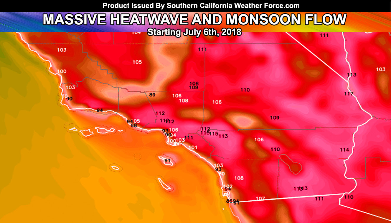
It is Friday and we are only a week away from one of the strongest monsoonal and heatwave events this region has seen since July 2006. Yes, that is 115 you are seeing in the Inland Empire and 106 in Downtown LA and 111/112 at Disney and Magic Mountain. What does it mean? Read on for details.
As stated in my preliminary July forecast we will see an opposite swing in both temps and monsoonal moisture than we had in May and June. So2 is leaving the area at a rapid rate due to the downwind profile we are of the Hawaiian volcanic activity.
Ongoing Text Ad: Furthermore we parted with our main summer-time advertiser and will need Summer help each year.. but you made it possible! If you are still interested (and I had many asking me how they can pitch in for this) in doing addon and upgrade help you can donate to SCWF in just a couple clicks by CLICKING HERE. Maybe we can get the video green-screen forecast software back!. I do appreciate all the help, especially making the goal to remain operational through the Summer. We are now complete on the goal keep operations this Summer without an advertiser. Thank you everyone who has helped. At this point it is about upgrades/addons as the server operations are now paid for.
After July 4th we will see a major increase in temperatures as one of the largest heat-domes (ridge of high pressure) develops directly in the center of the country. We will be on the southwestern edge of this clockwise flowing ridge of high pressure. This.. with major hurricanes to the south expected.. will create inverted troughs through the Southwestern United States, kicking off monsoon season with a bang with showers and thunderstorms all the way through metro Southern California by end this next week into next weekend..
If you have plans to go to Disneyland, Knotts, Magic Mountain, or Universal Studios.. change them. This type of heat in the basins is deadly. In addition to the heat, we will have unbearable humidity. So.. you have your warning from me.. in fact you’ve had it for well over a week or more now if you remain following me at Southern California Weather Force.
The reason we are hotter in the IE more-so than Palm Springs is the east/southeast flow right off the mountains, similar to an offshore wind (Santa Ana Pattern), however this will be a humid and hot even as shower/tstorm activity develops and moves through the area, utilizing the energy in the atmosphere (hot air rises) from those temps.
Catalina Island will be at 90F with humidity so this will be feel a lot like Hawaiian there so if you fancy a Hawaiian Vacation, hit that Island this next weekend (after the 6th) but take precautions hiking anywhere (not recommended)
Keep those pets, elderly, and you safe and I will report with additional warnings soon. The image above is my projected high temperatures by Friday or this next weekend (A week from now) …
SOUTHERN CALIFORNIA ONLY: if it does not say “Liked” LIKE The Page Below and join thousands of informed weather forecast viewers in our region for more of the updates! noticeable
BEHIND THE SCENES FORECASTS/UPDATE PAGE: if it does not say “Liked” LIKE The Page Below and join thousands of informed weather forecast viewers in our region for more of the updates! noticeable