The 2018-2019 storm season is becoming anticipated by many due to it being another El Nino, which typically brings us storm after storm. The SCWF fault model has shown enough to remove the earthquake watch so get all the details to that and El Nino’s progression into Fall and Winter by reading on.
First and foremost I’ll move into the earthquake updates. The SCWF California Fault-Stress Model continues to be on a decline. The trend has allowed for a quiet couple of weeks and will remain so until the trend moves up. Remember, free in the member section is the EQ model, which is updated daily now that I am back from the hospital and almost halfway recovered from the two broken ribs at the end of August. Until that trend starts to move up we should remain quiet.
Ongoing Ad Until End Month – The Southern California Weather Force has a member section with rain, wind, thunder, tornado etc models that are personally updated by me with each Santa Ana Wind or storm event. You also can get e-mailed alerts via a slew of micro-climates. Usually $50 a year the price has nearly been cut IN HALF as the discount that will go through till the end of August 2019. This is a yearly discount that I do so if you are a monthly contributor of $5 or $6.50 then I would upgrade to this and do it yearly each fall and you’ll save more.
Deal ends at the end of this month (September) so Click Here To Join or Upgrade Via The Member Section
Please remember if upgrading to CANCEL YOUR PAYPAL PAYMENTS. Login and cancel the reoccurring payments.
Now for the semi-details of the 2018-2019 storm season. The storm names will be released back to you soon. As you know I have named and categorized systems in our local area of Southern California since the early 2000s and there is no way I will stop now. Many storm systems have been remembered by the readers/viewers this way. One such would be Pacific Storm Freeman, a storm that brought snow to the Wildomar/Elsinore areas a few years back. Others like this year’s Major Pacific Storm RAYLENE, which caused the Santa Barbara/Ventura County Flood Event. (Video by clicking here) –
This season so far is still looking good to me. This time to the day last year Kern County (Bakersfield) was the only section in the area with a cutoff low that produced thunderstorms. The cutoff nature of the systems were highly apparent last year and this meant the atmosphere has a lot of blocking in it. This would caused less rainfall back to back and more of ‘when’ just one would hit and inundate an area, just as Major Pacific Storm Raylene did with one shot into Santa Barbara and Ventura County.
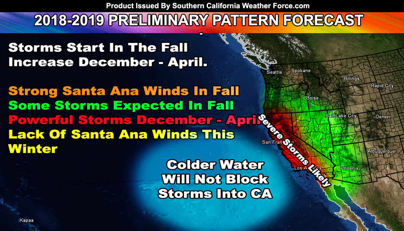
September 1st has started Meteorological Fall. It IS the fall season according to weather experts. We follow weather patterns, not astronomical patterns. September 15th is the official close of the monsoon season. Once this happens any moisture coming up from the tropics would be considered and mentioned as ‘tropical moisture’.. not monsoon moisture. This is still possible with a trough offshore.. any major hurricane near Baja could get sucked up toward us or Arizona before the month is over so this will continue to be monitored. My numbers do show a major warm-up the last week of September so this would make the Central/Eastern USA colder than normal and us warmer so this could be a tropical moisture event in our corner of the U.S..
I have yet to see the blocking this month so what this is telling me is it will show blocking in October and November. Blocking patterns within that time-frame have set up some of the strongest Santa Ana Wind Events and they have also set up some of the best storms in terms of thunderstorm dynamics should a low pressure system round the ridge and head into our area. I’m seeing a molded 1960-1980 era this season and some of those years had good rainy seasons.
El Nino is looking like a balanced Central-Based one thus far, not an eastern one. We have had some interesting events with cold arctic systems and strong tropical moisture fetch (severe storm) systems below a powerful Pacific jet stream with this type of El Nino location. Do think that Fall will have some interesting events, however they will be mixed with strong Santa Ana Wind Events and strong storms. My long range numbers are showing strengthening surface heights over the Idaho/Utah areas in November and this is signaling strong Santa Ana Wind Events on the near horizon.
The type of location of El Nino vs the temperatures near the Alaskan coast and cooler waters due west of here suggests that blocking at the surface will not be a problem like the failed 2015-2016 El Nino so we do not have to worry about the Martin El Nino Anomaly weakening our storm fronts.
After December onward would likely be where we get the most rainfall. January, February and March with April leaking off will be our best months this rainy season and if the Pacific Jet remains strong during the El Nino then we will see extremely powerful storms.. which is a good bet right now.
Well there you have it.. that is the preliminary of the season to come. I’ll have my final update near the storm of October so stay tuned to Southern California Weather Force for updates.
EMAIL ALERTS? Many micro-climate zones to choose from to get custom alerts from thunderstorm, wind, flood, surf, heat, cold, storm, and much more with the premium e-mail alert system, the most advanced zone alert system in Southern California – Click Here To Join!
SOUTHERN CALIFORNIA ONLY: if it does not say “Liked” LIKE The Page Below and join thousands of informed weather forecast viewers in our region for more of the updates! noticeable
BEHIND THE SCENES FORECASTS/UPDATE PAGE: if it does not say “Liked” LIKE The Page Below and join thousands of informed weather forecast viewers in our region for more of the updates! noticeable