Friday will be the warmest day of the week under the previously mentioned offshore flow, however this cutoff may mix in with some storm chances in our region by the weekend as it transverses the Martin Storm Diamond. Read more.
The cutoff system will be angled as such that we will get our gusty below pass and canyon winds on Friday, which will also up the temperatures in the metros. 90F is possible in spots with this type off pattern. The good thing is though this will not last too long because as the cutoff low enters southwest of here.. the upper dynamics will take hold and bring cloud cover, rainfall chances, and even the risk of thunderstorms in parts of the forecast area.
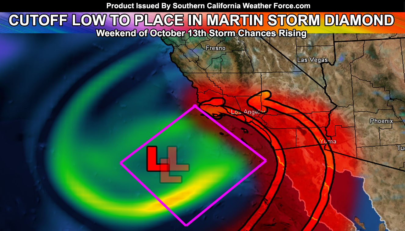
The cutoff system in the graphic for this article has 3 L’s. These are three of my calculations showing the center of the system on Saturday. They are closely tight together so this system is in pretty high confidence in trans-versing the Diamond (magneta color on the map in this article.
The Martin Storm Diamond is an imaginary diamond that is southwest of the forecast area. I’ve aptly named it after me of course. The center of storms that travel through this area have the best upper dynamics in our region, being northeast of the systems themselves. This region is what I look for when diving into confidence that we would see something over our land forecast area of Southern California.
The position of the low within the diamond matters. The further east in the diamond means further east into the Low and High Deserts will see action. The further south means San Diego and Imperial would see more than Ventura and of course the further north means that Kern County has the better chances.
The low is looking to cross the western end, which puts shower and/or thunderstorm activity as far west as Santa Barbara County and the most being between San Diego, Orange, and the Inland Empire areas east to the low deserts. The graphic has a red-shading.. use that to know what part of your county would be affected by the system.
Premium members, I will be updating a few products in the member section so be sure to check that out over the day.
End article
NOTE: Premium members. If you are signed up, your login is your e-mail address and the username and password as the password. You can change the password
Ongoing Ad – The Southern California Weather Force has a member section with LIVE UPDATES FOR EVENTS and rain, wind, thunder, tornado etc models that are personally updated by me with each Santa Ana Wind or storm event. You also can get e-mailed alerts via a slew of micro-climates. Check the member section for details on how you can support this service.. along with getting service in return… Click Here To Join or Upgrade Via The Member Section
Please remember if upgrading to CANCEL YOUR PAYPAL PAYMENTS. Login and cancel the reoccurring payments.
The Southern California Weather Force has different Facebook groups that you can ask for notifications from in order to get the latest posts affecting those regions. If that area is talked about in an article, alert, and such .. it’ll be posted there and you can be notified.
Comments are usually DISABLED as we do like to keep this as an information giving group and replies from others in the notification may annoy some.
Find your micro-climate group here – https://www.southerncaliforniaweatherforce.com/scwf-weather-alert-facebook-groups-by-region/
EMAIL ALERTS? Many micro-climate zones to choose from to get custom alerts from thunderstorm, wind, flood, surf, heat, cold, storm, and much more with the premium e-mail alert system, the most advanced zone alert system in Southern California – Click Here To Join!
SOUTHERN CALIFORNIA ONLY: if it does not say “Liked” LIKE The Page Below and join thousands of informed weather forecast viewers in our region for more of the updates! noticeable
BEHIND THE SCENES FORECASTS/UPDATE PAGE: if it does not say “Liked” LIKE The Page Below and join thousands of informed weather forecast viewers in our region for more of the updates! noticeable