Pacific Storm Peter has been named and is a category three here at Southern California Weather Force. The system will ignite clear skies this evening out of nowhere into thunderstorms with frequent lightning in the metro to desert zones, lasting all night into some of Saturday. Find out the details and if your area is in the thunderstorm zone by reading on.
Pacific Storm Peter is a cutoff low system that is placed in center the Martin Storm Diamond. The Martin Storm Diamond is an imaginary diamond that is southwest of the forecast area. The center of storms that travel through this area have the best upper dynamics in our region, being northeast of the systems themselves. This region is what I look for when diving into confidence that we would see something over our land forecast area of Southern California. This is such a storm.
The upper divergence, moisture, and instability profiles have not been seen this strong since Pacific Storm Avery in Sept 2007, which delivered an incredible lightning show to LA/OC and part of the Inland Empire. The divergence profiles suggests the VT/SBA area will be on the north end of the system, which does have lifting as well for thunderstorm activity. It however will not be as severe as further east in the issued Severe Thunderstorm Watch zone.
Speaking of watches, I have two. The thunderstorm watch (link here) is for the Ventura and Santa Barbara area, which is expected to be the weakest of the activity. I will not be taking this system to San Luis Obispo or Kern County, much less anywhere north of the Gorman Pass latitude so area like Fort Irwin to Ridgecrest are out.
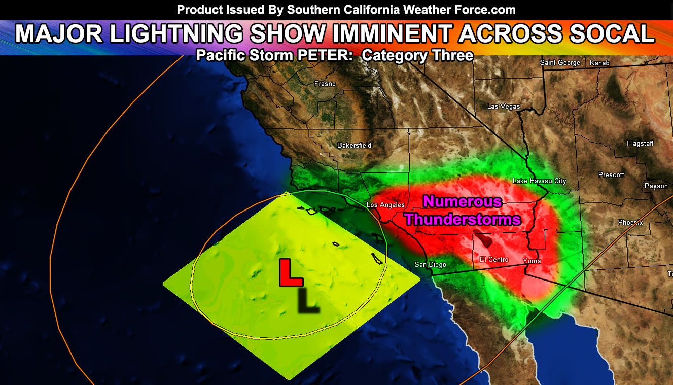
The Severe Thunderstorm Watch is for all of LA, OC, Riv, San Diego, and Imperial County, to the Southern half of San Bernardino County.
A trailing front will form with this as well for the low deserts, including Imperial County, Coachella Valley, and the CO River Valley forecast zones.
Some storms will produce local flooding, as well as gusty winds and even some larger hail, which could get to 1/2″ with the strongest cells.
The most concentration of severity within the storms will be in the Los Angeles, Orange, and Inland Empire areas, with weaker isolated activity toward Downtown San Diego due to a moisture issue where the event will not be as prolonged.
Members, check the member section throughout the day because products will be going out from noon through the evening for rainfall, thunderstorm areas, and even the live update section, which I’ll be in through most of this evening.
Category/Naming System – Click this link to see how it is done in our region.
End article
NOTE: Premium members. If you are signed up, your login is your e-mail address and the username and password as the password. You can change the password
Ongoing Ad – The Southern California Weather Force has a member section with LIVE UPDATES FOR EVENTS and rain, wind, thunder, tornado etc models that are personally updated by me with each Santa Ana Wind or storm event. You also can get e-mailed alerts via a slew of micro-climates. Check the member section for details on how you can support this service.. along with getting service in return… Click Here To Join or Upgrade Via The Member Section
Please remember if upgrading to CANCEL YOUR PAYPAL PAYMENTS. Login and cancel the reoccurring payments.
The Southern California Weather Force has different Facebook groups that you can ask for notifications from in order to get the latest posts affecting those regions. If that area is talked about in an article, alert, and such .. it’ll be posted there and you can be notified.
Comments are usually DISABLED as we do like to keep this as an information giving group and replies from others in the notification may annoy some.
Find your micro-climate group here – https://www.southerncaliforniaweatherforce.com/scwf-weather-alert-facebook-groups-by-region/
EMAIL ALERTS? Many micro-climate zones to choose from to get custom alerts from thunderstorm, wind, flood, surf, heat, cold, storm, and much more with the premium e-mail alert system, the most advanced zone alert system in Southern California – Click Here To Join!
SOUTHERN CALIFORNIA ONLY: if it does not say “Liked” LIKE The Page Below and join thousands of informed weather forecast viewers in our region for more of the updates! noticeable
BEHIND THE SCENES FORECASTS/UPDATE PAGE: if it does not say “Liked” LIKE The Page Below and join thousands of informed weather forecast viewers in our region for more of the updates! noticeable