Hope you all had a great Thanksgiving, whether you had Turkey, Ham, Prime Rib, Denny’s, or even McDonalds. On the heels of the last system, another system is slated to arrive into the metros by later Wednesday into Thursday of this next week, which looks a bit better than the last one. This would be followed by additional systems through December so read on for details …
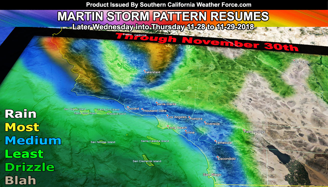
Welcome to Southern California Weather Force. Many were asking why I didn’t predict the rainfall around Thanksgiving or update on the system? Well, remember the golden rule here. If the forecast remains the same then nothing will be updated. There simply is no need for repetitive updates unless additional details follow it. The storm forecast was here so Click Here. So.. with the Martin Storm Pattern resuming next week into early December, public and member updates are resuming on schedule. The focus system for down here and into the rest of California will be the Thursday system.
Like the last system, this system will be giving us a tail-end charlie frontal zone that will zip on through while Central/Northern California gets the brunt of the flooding rains, severe thunderstorms, and damaging winds. Still.. it is the beginning of our season down here and like turning the key to a car’s ignition.. we are just getting started on our engine to turn fully on.
Some details with the later Wednesday into Thursday system that I can give will be it’ll bring more rain than the last one I believe. I also see a stronger surface low offshore Northern California to bring gusty winds with it. For our area it’ll mainly be San Luis Obispo, Vandenberg Air Force Base, Orange and San Diego County. Could be a squall-line in these areas so alerts will go out when warranted. For other areas, look at the map provided within the article image.
As for December.. my preliminary forecast outline shows it’ll be stormy still so we are just getting deeper into the El Nino Season and it looks good for rainfall so far. That forecast will be out beginning December when it looks like another system might be looming.
End
NOTE: Premium members. If you are signed up, your login is your e-mail address and the username and password as the password. You can change the password
Ongoing Ad – The Southern California Weather Force has a member section with LIVE UPDATES FOR EVENTS and rain, wind, thunder, tornado etc models that are personally updated by me with each Santa Ana Wind or storm event. You also can get e-mailed alerts via a slew of micro-climates. Check the member section for details on how you can support this service.. along with getting service in return… Click Here To Join or Upgrade Via The Member Section
Please remember if upgrading to CANCEL YOUR PAYPAL PAYMENTS. Login and cancel the reoccurring payments.
The Southern California Weather Force has different Facebook groups that you can ask for notifications from in order to get the latest posts affecting those regions. If that area is talked about in an article, alert, and such .. it’ll be posted there and you can be notified.
Comments are usually DISABLED as we do like to keep this as an information giving group and replies from others in the notification may annoy some.
Find your micro-climate group here – https://www.southerncaliforniaweatherforce.com/scwf-weather-alert-facebook-groups-by-region/
EMAIL ALERTS? Many micro-climate zones to choose from to get custom alerts from thunderstorm, wind, flood, surf, heat, cold, storm, and much more with the premium e-mail alert system, the most advanced zone alert system in Southern California – Click Here To Join!
SOUTHERN CALIFORNIA ONLY: if it does not say “Liked” LIKE The Page Below and join thousands of informed weather forecast viewers in our region for more of the updates! noticeable
BEHIND THE SCENES FORECASTS/UPDATE PAGE: if it does not say “Liked” LIKE The Page Below and join thousands of informed weather forecast viewers in our region for more of the updates! noticeable