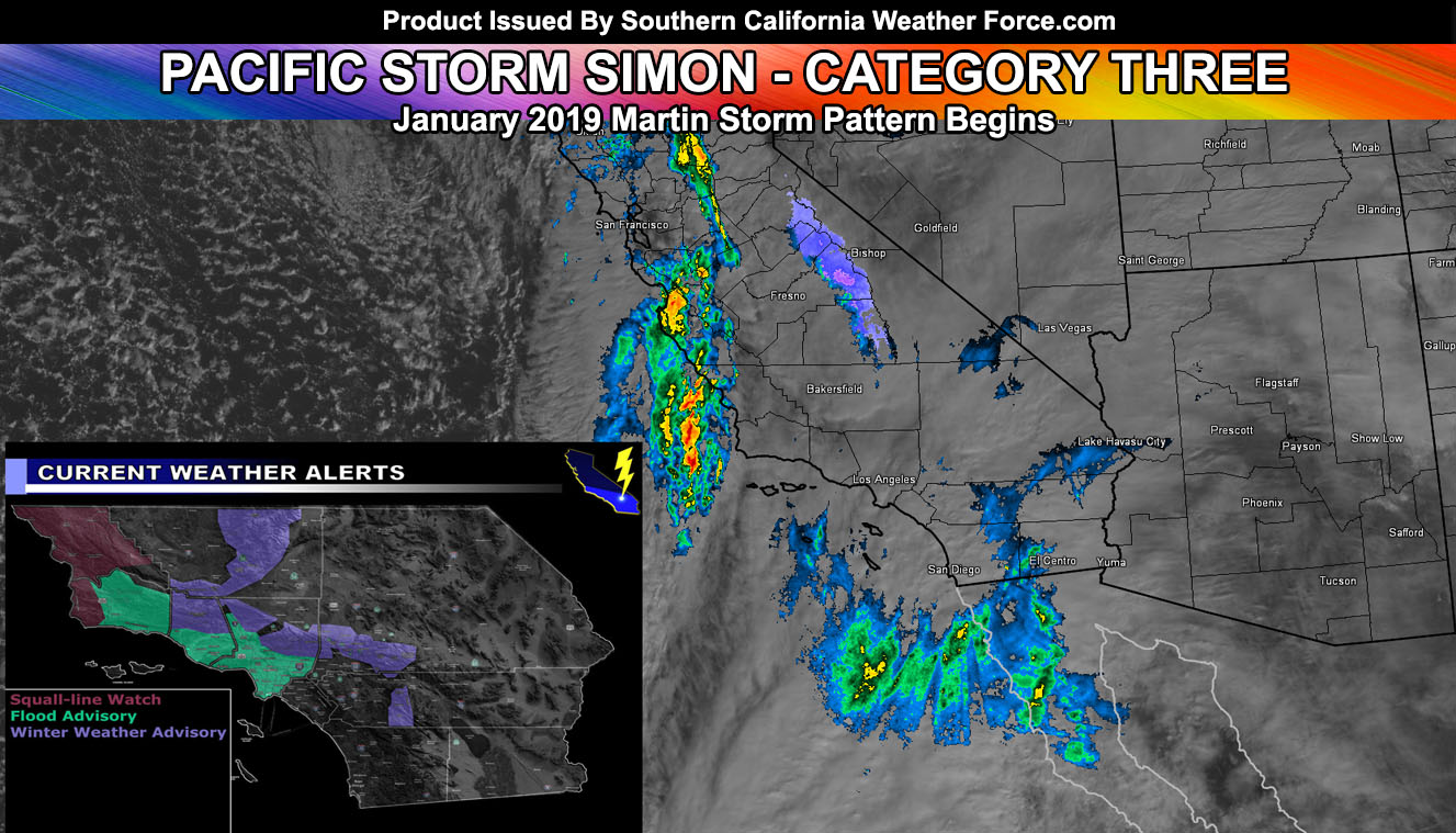
The Martin Storm Pattern opens up with Pacific Storm Simon, a category three system on my one through six scale. This moderate fast moving system will impact Vandenberg this afternoon and shove through the metros of Los Angeles overnight tonight. San Diego will see the least from it but three alerts are currently issued so read on for details …
I want to note that if you just recently signed up as a premium member your email address on file is your username and the password is the word password – I have been very busy with the system and just got to all the sign-ups today.
There are three alerts right now on the site.
The Squall-line Watch is for the Vandenberg to San Luis Obispo forecast zones and is in effect now for the frontal zone passage. One may be needed in Orange County later on should this squall-line develop as I think. It will be a broken line..but strong winds will accompany parts of it. A potent quick moving system known as Pacific Storm SIMON will affect the area today and tonight, with a slight break in activity by Sunday morning, with returning rainfall over the day on Sunday. A wet pattern, the Martin Storm Pattern is emerging. This squall-line watch is due to the strong winds I expect with the front, with gusts in excess of 40+mph in the Vandenberg AFB to San Luis Obispo County areas today. There is a chance of thunderstorms as well during this event … but for now will stick to heavy rainfall and gusty winds that can bring poles/trees down in the watch area.
The Winter Weather Advisory is in effect at SCWF for the following zones; Kern, Ventura, Los Angeles, San Bernardino and Riverside Mountains above 4,000 FT … Cajon/Gorman/Phelan and Highway 18 from Hesperia to Lucerne Valley …
A potent fast moving storm system dubbed Pacific Storm SIMON will move through the area today and tonight. This system will drop heavy snowfall in parts of the Los Angeles and San Bernardino Mountains, with marginal amounts elsewhere. The snow level may dip to 4,000 FT, which will put the Gorman and Cajon Pass at the snow and freezing rain level for traffic hazards so be advised of this.
PREMIUM MEMBERS can go to the link below for the zoom-able snow-model map here at SCWF of this event. But.. I will give select amounts for areas here …
Tehachapi – Dusting
PMC/Frazier – 1-3″
Wrightwood – 1-3″ with more on Highway 2 near Mt Baldy at over a foot. Rain shadow will be there for WW.
Big Bear Lake – 1-3″ east end and 5-7″ west end along the rim.
Cajon Pass and Phelan – Dusting
Forest Falls – 5-7″
Idy – 4-6″
Mt Laguna (not in this advisory) – Dusting
The Flood Advisory is for Santa Barbara, Ventura, and Los Angeles County. Rainfall will start in Santa Barbara later this afternoon or early evening and this strong front will push eastward at a pretty fast pace. SCWF Flood Risk model in the member section shows a moderate flood risk in all advisory locations through tonight. Local small stream flooding is possible.. but it will not be a burn area risk like a Flood Warning contains. Most areas will receive between a half inch to an inch of rainfall from this system. Pacific Storm SIMON may contain isolated lightning strikes, especially near Long Beach where instability is more plentiful. Waterspouts land-falling as small tornadoes are also possible …
As for the rest of the area… The broken squall-line will move through OC the strongest and the IE/SD areas the weakest. Gusty winds will accompany all areas within the squall, but do not expect too much in San Diego like Los Angeles, Ventura, and Santa Barbara will see.
This tropical moisture plume will also bring rainfall to the Low Desert zones, including Imperial to the CO River Valley forecast areas. Not much is expected.. .but it will be enough to make things slick.
There will be a break everywhere over the day on Sunday.. but on Sunday night another plume moves into the Vandenberg to San Luis Obispo County areas, going as far east as Ventura County. This will largely miss the metros south and east of Los Angeles.
Pacific Storm TRUMP is next on the list and is expected within the week … stay tuned …
End
NOTE: Premium members. If you are signed up, your login is your e-mail address and the username and password as the password. You can change the password
Ongoing Ad – The Southern California Weather Force has a member section with LIVE UPDATES FOR EVENTS and rain, wind, thunder, tornado etc models that are personally updated by me with each Santa Ana Wind or storm event. You also can get e-mailed alerts via a slew of micro-climates. Check the member section for details on how you can support this service.. along with getting service in return… Click Here To Join or Upgrade Via The Member Section
Please remember if upgrading to CANCEL YOUR PAYPAL PAYMENTS. Login and cancel the reoccurring payments.
The Southern California Weather Force has different Facebook groups that you can ask for notifications from in order to get the latest posts affecting those regions. If that area is talked about in an article, alert, and such .. it’ll be posted there and you can be notified.
Comments are usually DISABLED as we do like to keep this as an information giving group and replies from others in the notification may annoy some.
Find your micro-climate group here – https://www.southerncaliforniaweatherforce.com/scwf-weather-alert-facebook-groups-by-region/
EMAIL ALERTS? Many micro-climate zones to choose from to get custom alerts from thunderstorm, wind, flood, surf, heat, cold, storm, and much more with the premium e-mail alert system, the most advanced zone alert system in Southern California – Click Here To Join!
SOUTHERN CALIFORNIA ONLY: if it does not say “Liked” LIKE The Page Below and join thousands of informed weather forecast viewers in our region for more of the updates! noticeable
BEHIND THE SCENES FORECASTS/UPDATE PAGE: if it does not say “Liked” LIKE The Page Below and join thousands of informed weather forecast viewers in our region for more of the updates! noticeable