After Pacific Storm Achilles we have more storm systems lined up starting Tuesday of this next week and going on from there till mid-month where my numbers show a weakening storm pattern trend and even the hint of a Martin Storm Diamond System. Hello NASCAR weather! Read on for details …
Pacific Storm Achilles rated a meager category two as expected. Seriously considering upping the standards to be called a Pacific Storm unless it is a three or higher. Thinking to change the name for a category two to Pacific System rather than ‘storm’ because storm it is not. A category three would fair better to be called a Pacific Storm. Of course, anything higher is a Major Pacific Storm. So we’ll just leave it at that and make the change now.
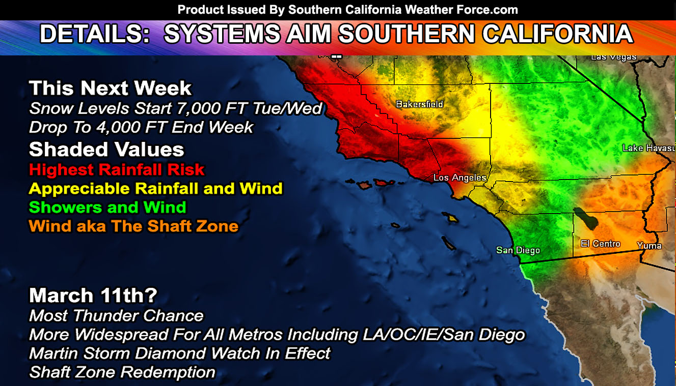
The next system is due into the forecast area on Tuesday into Wednesday. This system is stronger overall than Achilles is. Going to maintain the original thought with these systems with San Diego seeing the outskirts and weaker rainfall, Los Angeles so-so, and areas like Ventura, Santa Barbara, San Luis Obispo, and some Kern locations seeing the most from it. The ridge is just way too strong over Cabo San Lucas to say a Pineapple Express will affect San Diego or the Inland Empire so this system will be like our current one this weekend, most of the heavy rain and flooding west of Los Angeles. This one however on Wednesday does have more wind dynamics in the low levels for stronger wind gusts over San Diego than the flood risk zones. Ingredients are definitely mixed and matched right now with it. The snow level with the Tues/Wed system will be around 7,000 FT with an even colder ‘type’ of system coming by the end of the week with snow-levels between 4,000 – 5,000 FT, meaning this would also affect some of the San Diego County Mountain areas.
The last system in the line would hit around March 11th. This one is going to be more of an interest to me. My long-range pattern development numbers say this one will be detached from the main jet stream and break the ridge over Cabo San Lucas down. Should this happen, and it looks like the chances are high… it will become a Martin Storm Diamond system. Martin Storm Diamond Systems favor thunderstorm dynamics into metro Southern California. In other words… if you like thunderstorms then your best bet at widespread thunderstorms through the next storm stream will be surrounding March 11th, especially Los Angeles, Orange, The Inland Empire, and San Diego, whereas you in San Diego you will get more rain and thunder dynamics from the last system surorunding March 11th than the ones this next week.
After that… we dry up as the storm pattern pulls away from Southern California and we have seasonal temperatures. I am still going to go with a nice NASCAR weekend and I’ll be there of course so I will definitely keep watching the pattern. Confidence is gaining at the time for a good weekend.
As always, stay tuned to Southern California Weather Force for further details. Look at the links below for help, including the ‘Optional’ link if you want to see the flood/rain risk maps on the main SCWF page. Everything is updated accordingly before an event.
OPTIONAL: Southern California Weather Force main page now has models, agendas, the alert map, and other things updated during storm events. You can bookmark the main site and check back during an event for the latest updates.
Click here to view the main page
EMAIL ALERTS: It pays for itself in one storm system. A very affordable e-mail alert system that only gives you SCWF weather alerts in YOUR micro-climate area.
Click here to join
MICRO-CLIMATE ALERT FACEBOOK GROUPS: Find yours today!
Click here to join
SOUTHERN CALIFORNIA ONLY: if it does not say “Liked” LIKE The Page Below and join thousands of informed weather forecast viewers in our region for more of the updates! noticeable
BEHIND THE SCENES FORECASTS/UPDATE PAGE: if it does not say “Liked” LIKE The Page Below and join thousands of informed weather forecast viewers in our region for more of the updates! noticeable