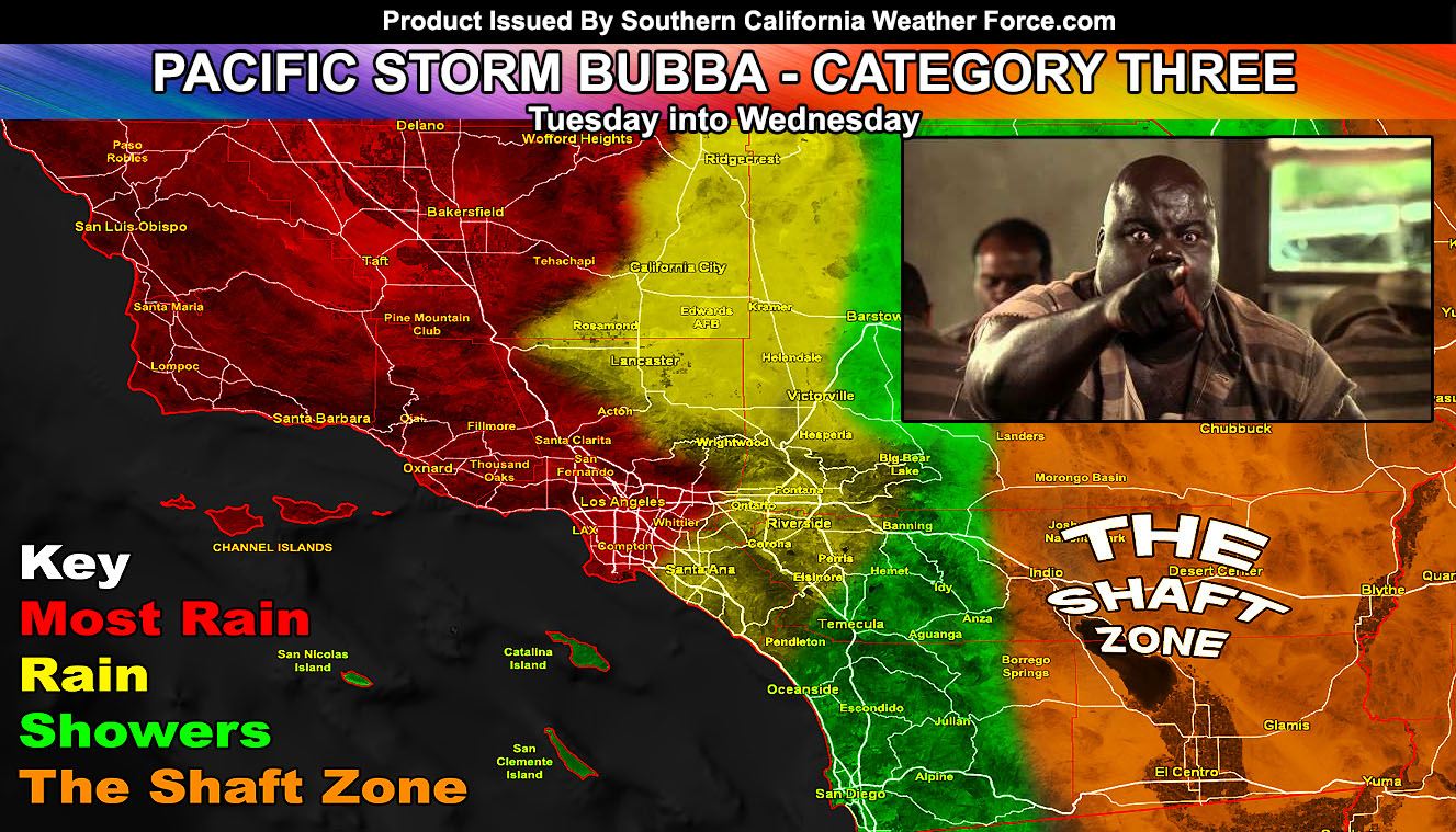
As stated back on March 2nd, this Pacific Storm would mainly affect Los Angeles westward, with Santa Barbara and Ventura at the center of the most rainfall dynamics. This looks right on target and I have two alerts issued. There will also be a chance of thunderstorms in spots. Read on for details.
I have issued a Flash Flood Watch for the following areas; San Luis Obispo/Santa Barbara County … Kern Valley … A frontal-zone is now affecting San Luis Obispo County as I type this. This frontal zone is the leading edge of a 700-mile stream of sub-tropical moisture extending well into the Pacific, aiming the warning areas. The heaviest rainfall in the watch zone will in no doubt be this evening into the overnight and through Wednesday morning. The SCWF Flood Risk model has an extreme to high risk in the watch area, which prompts the issuance of the flash flood watch. In the burn areas, we will see 2-3″ of rainfall in a short period of time. There is also a chance of thunderstorms in the strongest cells. The Flash Flood Watch will expire Wednesday at noon when rainfall rates will be below flood thresholds.
I have also issued a Flood Advisory for the following areas east of the Flash Flood Watch; Los Angeles and Ventura County Metros … Kern County Mountains … Northern Kern Deserts – Ridgecrest…; The frontal zone will affect the advisory area mainly this evening, overnight tonight, and into Wednesday morning. Rainfall amounts will average 1″ for the advisory area with 2+” for the Ventura County burn areas surrounding Ojai and 0.50 to 0.75 for Ridgecrest. Some of my numbers shift the flood warning to the Ventura County burn areas so consider this a Flash Flood Watch there, with advisory level conditions west into Los Angeles. Small stream flooding is likely in the advisory zone. There is also a chance of thunderstorms in the strongest cells. The Flash Flood Watch will expire Wednesday at 3 pm, when rainfall rates will be below flood thresholds.
For the rest of the forecast area … This frontal-zone will weaken very quickly as it moves south/east of Los Angeles County. My rain model clearly shows this dividing line, which can be seen on the main website. The dividing line shows a half-inch in the Western High Desert surrounding The Antelope Valley to Edwards and a good 0.50″ – 1.00″ for the OC/IE areas with a quarter inch in most San Diego County Metro zones. Really again like the last one, San Diego County you are within the weakest metro zone of this system for rainfall totals.
Wind gusts will be widespread across the entire region. The region will see 30 mph wind gusts in the metros, sometimes 40. 40-50 mph in the deserts, and 50 mph and higher in all mountain locations. Areas in the Flash Flood Watch zones above will see 40-50 mph wind gusts and possibly downed powerlines and trees.
Because of the lack of frontal zone making it only halfway across the forecast area, the category would dwindle from 4 to 3. The storm’s center would hit the Flash Flood Watch and Advisory zones as a category three, with two in the OC/IE areas and a one in San Diego.
The snow level with the Tues/Wed system will be around 7,000 FT with an even colder ‘type’ of system coming by the end of the week with snow-levels between 4,000 – 5,000 FT, meaning this would also affect some of the San Diego County Mountain areas.
The last system in the line would hit around March 11th. This one is going to be more of an interest to me. My long-range pattern development numbers say this one will be detached from the main jet stream and break the ridge over Cabo San Lucas down. Should this happen, and it looks like the chances are high… it will become a Martin Storm Diamond system. Martin Storm Diamond Systems favor thunderstorm dynamics into metro Southern California. In other words… if you like thunderstorms then your best bet at widespread thunderstorms through the next storm stream will be surrounding March 11th, especially Los Angeles, Orange, The Inland Empire, and San Diego, whereas you in San Diego you will get more rain and thunder dynamics from the last system surrounding March 11th than the ones this next week.
After that… we dry up as the storm pattern pulls away from Southern California and we have seasonal temperatures. I am still going to go with a nice NASCAR weekend and I’ll be there of course so I will definitely keep watching the pattern. Confidence is gaining at the time for a good weekend.
As always, stay tuned to Southern California Weather Force for further details. Look at the links below for help, including the ‘Optional’ link if you want to see the flood/rain risk maps on the main SCWF page. Everything is updated accordingly before an event.
OPTIONAL: Southern California Weather Force main page now has models, agendas, the alert map, and other things updated during storm events. You can bookmark the main site and check back during an event for the latest updates.
Click here to view the main page
EMAIL ALERTS: It pays for itself in one storm system. A very affordable e-mail alert system that only gives you SCWF weather alerts in YOUR micro-climate area.
Click here to join
MICRO-CLIMATE ALERT FACEBOOK GROUPS: Find yours today!
Click here to join
SOUTHERN CALIFORNIA ONLY: if it does not say “Liked” LIKE The Page Below and join thousands of informed weather forecast viewers in our region for more of the updates! noticeable
BEHIND THE SCENES FORECASTS/UPDATE PAGE: if it does not say “Liked” LIKE The Page Below and join thousands of informed weather forecast viewers in our region for more of the updates! noticeable