Numerous thunderstorms hit Southern California as both middle and low-level instability was present, creating a light-show many will remember for a while, hence remembering the name Pacific Storm BUBBA, a category three out of six system. Category three systems are notorious for their thunderstorm chances since the category system works on damage chances rather than what happens. Another round is expected later Thursday into Friday so read on for details as snow levels start to also lower.
Pacific Storm Bubba remained a category three for his entire lifetime thus far. Many are asking me why did I not go any higher. Well, the category system needs a combination of area, rainfall intensity, flood risk, thunderstorm type, and wind gust damage to calculate a number. Numerous category three systems have done what Bubba has done, including October 2007’s Pacific Storm Carl and likely the next one on Monday Pacific Storm Carolina. Category 4-5-6 is reserved for the strongest frontal zones where those winds knock over numerous powerlines and trees along the damage path. This one was not one of them, thus remains a category three.
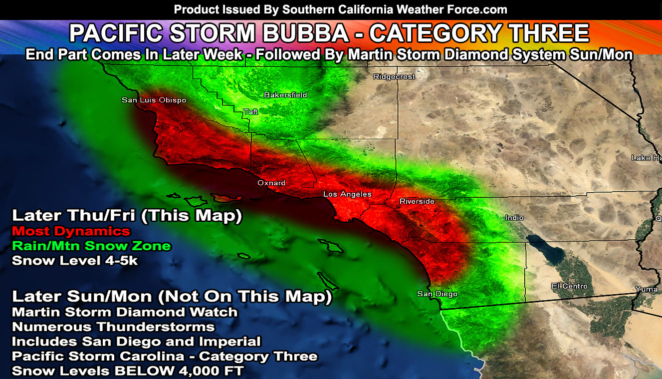
But we are not done yet! Pacific Storm Bubba’s end piece of dynamics will move into the SLO/Santa Barbara zones later Thursday and Friday morning through the VT,LA/OC/SD/IE Metro areas. This has yet again the chance of thunderstorms in my forecast as it moves through. The orientation and flow will make it possible for this system to have snow levels between 4,000 – 5,000 FT as further stated back on March 2nd’s article update. This means that the I-5 corridor in that time-frame will have the risk of snowfall, as well as some Riverside/San Diego County Mountains areas, north to the San Bernardino Range. Will need winter weather advisories for those zones. As for the Wrightwood zones, the flow is meager and not as favorable as other areas so a dusting is possible there, but certainly not expecting much. The system will have some heavy cells and as I mentioned a thunderstorm risk in the SLO/Santa Barbara/VT/LA/OC/IE and even ‘some’ of the San Diego County areas, but no large scale flooding is expected at the time.
As for the storm system that will be now named Pacific Storm Carolina, category three, she will enter the forecast area on Sunday and peak later into Monday. This system has strong mid and low-level instability with it, thus crossing the MARTIN STORM DIAMOND. The Martin Storm Diamond is a diamond-shaped zone southwest of the forecast area that when the center of an upper level low moves into it we get widespread thunderstorm activity, including our mountain and desert regions, named after me, due to discovering it long ago. The snow level with the diamond during this storm will be below 4,000 FT due to a northeast dry air coming into the system. This means that you all in the passes and high desert areas will see some snow with it, possibly even that thundersnow category.
Another system moves in after that later Tuesday into some of Wednesday and after that, we dry out just in time for NASCAR weekend, which I will be there on Sunday. We will have a couple more off and on systems before the month ends, however, I do not see any tropical moisture connections at the time.
As always, stay tuned to Southern California Weather Force for further details. Look at the links below for help, including the ‘Optional’ link if you want to see the flood/rain risk maps on the main SCWF page. Everything is updated accordingly before an event.
OPTIONAL: Southern California Weather Force main page now has models, agendas, the alert map, and other things updated during storm events. You can bookmark the main site and check back during an event for the latest updates.
Click here to view the main page
EMAIL ALERTS: It pays for itself in one storm system. A very affordable e-mail alert system that only gives you SCWF weather alerts in YOUR micro-climate area.
Click here to join
MICRO-CLIMATE ALERT FACEBOOK GROUPS: Find yours today!
Click here to join
SOUTHERN CALIFORNIA ONLY: if it does not say “Liked” LIKE The Page Below and join thousands of informed weather forecast viewers in our region for more of the updates! noticeable
BEHIND THE SCENES FORECASTS/UPDATE PAGE: if it does not say “Liked” LIKE The Page Below and join thousands of informed weather forecast viewers in our region for more of the updates! noticeable