A 4.2 shaker hit Joshua Tree National Park on a previously thought to be extinct fault-zone, Multiple monsoonal impulse moving in through mid-week. What is next? Your forecast starts now …
Video Version: https://www.facebook.com/scweatherforce/videos/385717748721383
First, I do want to get the earthquake out of the way. This earthquake was light, a 4.2 magnitude center in the center of the Joshua Tree National Park zone. I looked for the fault that could cause it and I saw the Pinto Hills Fault Zone, which runs along Highway 62 in the Morongo Basin Metro City areas. This fault however is a vertical cut fault and would not fit where this quake hit. The aftershock that hit after showed it would be an east to west oriented fault-zone and I came across the Blue Cut Fault Zone, which fits the location. The thing about this zone is it is over 1.6 million years old, or since the last rupture happened there. This is leading me to believe this quake happened on a fault that was previously thought to be extinct and it is a long one so if it ruptures, 7.0 or larger would be possible with it. The fault is the same age as parts of the Garlock Fault and the swarms directly on that fault remain. The California Fault Stress Model is maintaining very high levels of spikes so I have no reason to say that we will not have anymore quakes, even far away from both Ridgecrest and Joshua Tree National Park so remain earthquake prepared.
The monsoon ridge is finally showing the impulses into our region as noted by the tropical clouds in the area and up in humidity … oh yes… it feels miserable out there with even dewpoints in the 70s. When we look at tropical moisture, we look for dewpoint, not humidity. They are much different. The dewpoint in the 50s is dry, 60s is uncomfortable and somewhat sticky, and 70s is down right sticky where you feel like you can swim in the atmosphere and fly like Peter Pan..second star to the right and straight on to a morning.
The first impulse has moved through the metros and many have reported drops of rain falling. There was indication in the cloud tops that isolated lightning potential could have been possible with it.
The second impulse will move through later today. The visible satellite shows a clearing behind the first impulse across the San Diego and Riverside County Mountains. With the onshore flow developing in the afternoon, offshore flow from the monsoon ridge would set convergence in that area for showers and thunderstorms to develop. The second impulse will arrive later on out of Northern Mexico. Yesterday’s projection of the impulses seems on target so far, with the first going through Orange and Los Angeles County and the second right up the Riverside/San Diego County Mountain spine, heading north-northwestward, which can affect some nearby valley zones, including some of the Inland Empire as it goes north to Big Bear and into the High Desert. Additional spiral bands around this impulse would affect the Low Desert as well through the evening and into the night so enhanced probabilities exist there too.
The third impulse will rely on severe thunderstorms just east of Phoenix and Tucson today. This would shove a major outflow boundary westward, giving dust storms for both of those cities and make way for the Southern California areas for your Tuesday. Should this happen as expected, pending debris clouds in the morning, Tuesday could be the most activity day and the cone of probability for this from yesterday still remains for today’s forecast.
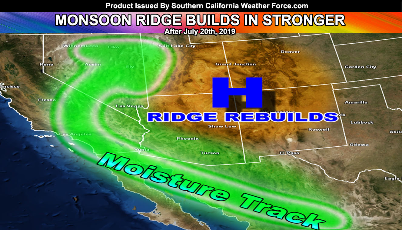
The ridge migrates over Phoenix, Arizona by the end of the week and shuts the moisture flow off under suppressed skies and sinking air straight on into a nice weekend. The monsoon door opens once again next week around the same time it did this week and we do it all over again, with the flow coming out of Arizona and Northern Mexico for the return of monsoonal moisture by the very end of the month and into the first week of August.
That is it, there you have it… the first impulse is heading out, the second one heading in, and awaiting the third one on Tuesday with nice end week to weekend conditions coming up and a return to the monsoonal moisture window the same time next week so stay tuned to Southern California Weather Force