Alright welcome back to Southern California Weather Force. Over this past week we had monsoonal moisture briefly leak into the area, bringing light showers for some and even thunderstorms for others, some of those being severe.
On August 6th, a forecast was released here at Southern California Weather Force for the next day, August 7th. This would be for how far the monsoonal moisture flow would go, and that would be just short of Santa Clarita to the west of Pasadena in the isolated section. The red section was for where the most storms would hit and a weather advisory was issued mainly for the red-zones where numerous storms were in my forecast. Sure enough, numerous storms impacted on August 7th and even an isolated thunderstorm cell moving from Sylmar through Acton and into the Antelope Valley around Palmdale and Lancaster. This matched the forecast completely.
The following day, a forecast went out of a small section of the forecast area having showers and thunderstorms, which would include the Needles, California forecast zone, our most east-northeast border of the Southern California Weather Force Jurisdiction. Pop up storms did happen in this zone as we briefly end the monsoonal moisture period.
One thing I am highly looking at is the general pattern. In Inland Empire’s city of Riverside is where I generally look at to get an idea of a trend in above or below normal temperatures for our region. So for this next week you can see that Tuesday will be the hottest day, with 100 returning to that city and 110+ for the low deserts. A trough dips down again and drops the temperatures after Tuesday like what happened this last week in our weather.
Now, if the current troughs remain on course, the ridge would be allowed to forcibly build at a very quick rate after August 20th or 21st. This would build in and the passing troughs would migrate the ridge westward from the four corners. Should this happen, the dome of high pressure would return monsoon moisture to the region with temperatures in the 100s the in inland metros and nasty humid conditions mixed into it. So that is definitely the next focus. Some numbers generate dangerous conditions, others a bit more meager.
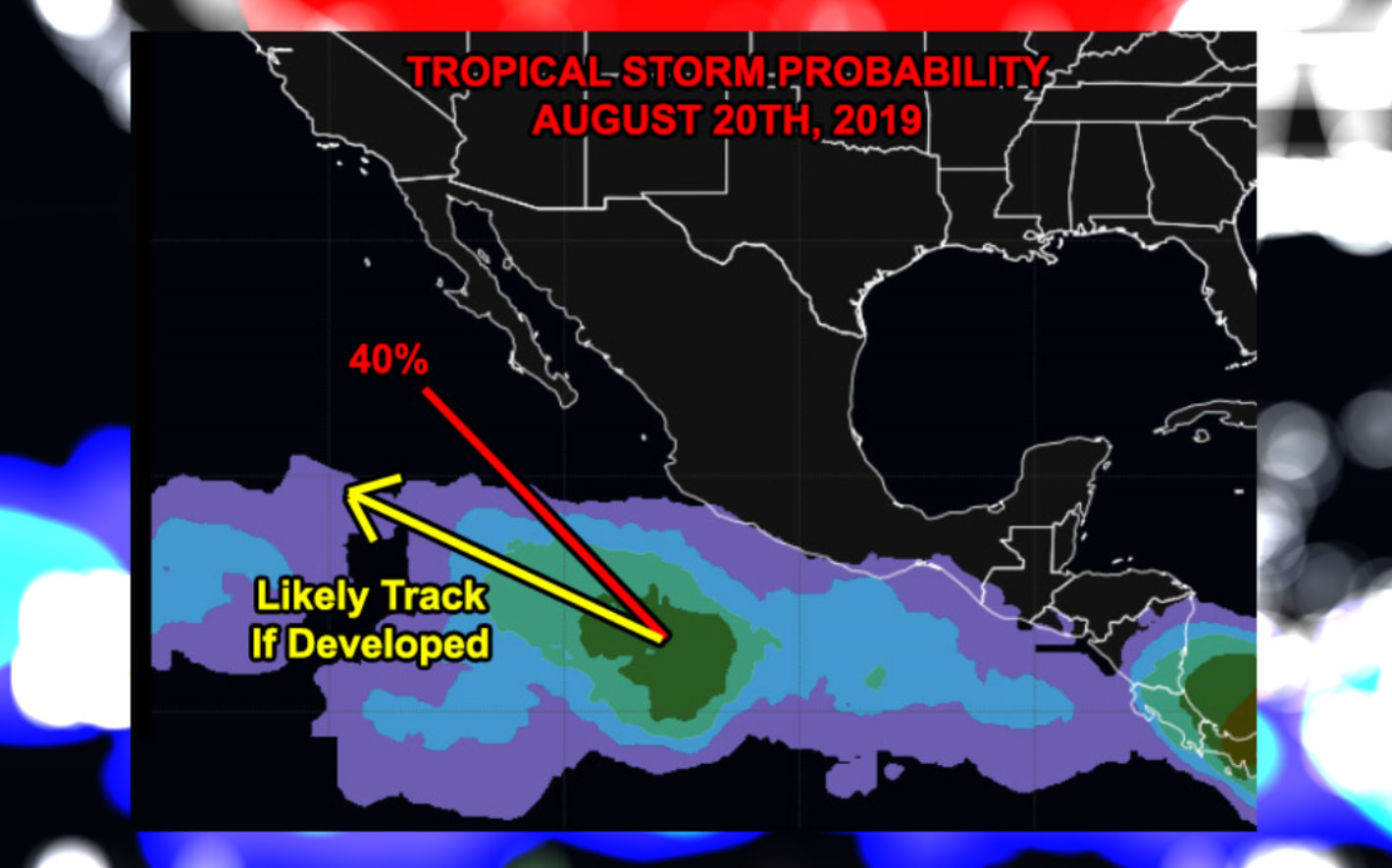
Given what I see in this mid-summer, Troughs can actually suck up moisture and tropical systems. But… we are lacking systems so far this season and my long range numbers don’t even have the storms down in Mexico for us to gain moisture from, a reason for this meager feast of a monsoon season thus far here. September is the peak season for Hurricanes and the Monsoon Season ends on September 15th. We easily could get a tropical system hooking northward from the troughs in September and into our region. This would be possible this month as well AS LONG AS WE GET A SYSTEM FORMING. We have the troughs, we just need the systems.
Current atmosphere also bodes well for the coming 2019-2020 storm season. Troughs like this sticking in this manner means that we will have weaker ridges, cooler offshore waters, and better chances for frontal zones to make their way in. I do not see the Martin El Nino Anomaly yet. The Martin El Nino Anomaly is what I discovered just before the 2015-2016 Super El Nino and the reason I went with less events. It is an area of warmer water some 500 miles west of here and this created a surface ridge of high pressure that deflected storms into Northern California, leaving us high and dry. I do not see that yet so cross your fingers one does not form if you like the rain. Thus far, the troughs are keeping the ocean there cooler than average so confidence is rising is a good season yet again.
As for the Earthquake Charts. We are at caution, not unstable. We seem to be calming down some but remain at caution. These ULF spikes are dropping each week.
Well that is it, below average temperatures from now through the 20th, a brief spike in temperatures and monsoonal moisture after that, and to keep an eye on September’s tropical zone for any development, which would hook systems up to our region so stay tuned to Southern California Weather Force