In what can be considered the most dangerous Santa Ana Wind Pattern of the season thus far with the ridge placement, dry air, and the heatwave in progress, the placement is that of the November 2003 and October 2007 firestorm events and must be monitored carefully so read on for details …
As stated in the previous article, this week would feature a heatwave lasting the entire week and a Santa Ana Wind Event (Click For Warning Map). The ridge of high pressure responsible for this heat will move to west of Northern California.
This clockwise rotation around it will be what will be responsible for bringing in upper support in the area. Upper support generally brings stronger wind gusts and going with 40-60 mph with 80+ mph in favored areas. This is a dangerous event, with damaging wind gusts in prone zones, hot temperatures, and dry air, similar to that of November 2003 and October 2007 so stay alert because that period yielded some of the worst fires in the region.
This event will also delay and/or divert arrivals at Ontario International Airport on Thursday so check ahead of time. Diverts are usually taken to Phoenix or Las Vegas.
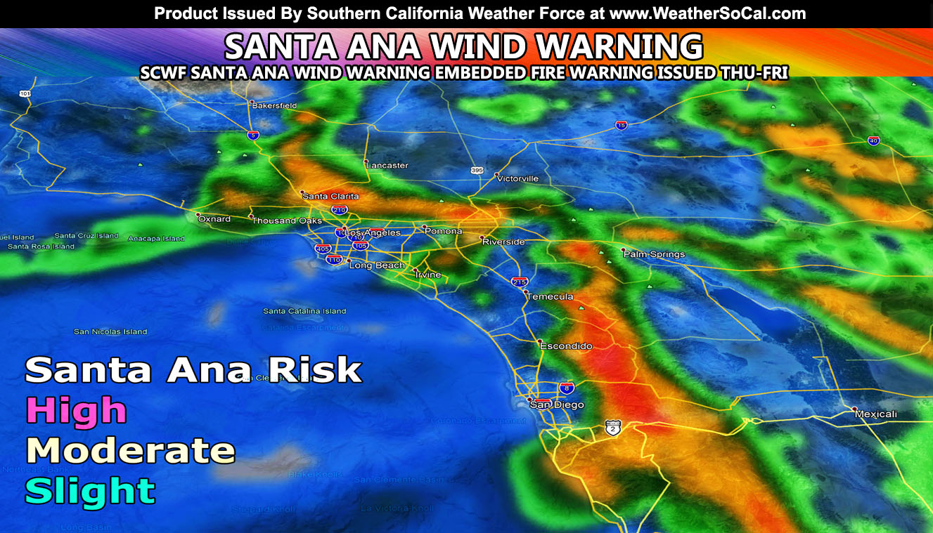
The included alert map above shows the zones SCWF has and it shows which areas will see the winds above my advisory level and which will not. Clearly you can see the LA Basin and some Perris/Yucaipa/Temecula and San Diego Coastal zones not seeing it either and the shaded result is a Fire Weather Warning. This is how precise the alert system is. Santa Ana Wind effects will be felt across the Kern County Mountains as well with the east flow and the northerly flow for the Eastern Low Desert along the Colorado River Valley.
The winds will be stronger in San Diego’s Mountains on Friday than on Thursday and all winds cease by the weekend where we will have a gradual cool-down and a nice cool week after this for Halloween under deeper marine layer and onshore flow with drizzle/light rain at times under it. A gloomy … scary Halloween is forecast on SCWF grids … muahahaha\
MICRO-CLIMATE ALERT FACEBOOK GROUPS: Find yours today!
Click here to join
NOTE: TIME IS RUNNING OUT. IF THIS TROUGH GETS A NAME THEN THE DISCOUNT WILL HAVE ENDED… If you have renewed your discounted MICRO-CLIMATE E-MAIL ALERT SYSTEM membership for the 2019-2020 season, skip this message. If you have not, Click Here To Renew. This will be one of your last e-mailed article/alert from the 2019-2020 season as effective now the season will start when the first named storm system enters the region so don’t wait. Click Here To Renew Under The Discount.
As always, stay tuned to official forecasts from Southern California Weather Force for updates …
For The Main Weather Facebook Page Click Here and Join.
End Article
OPTIONAL: Southern California Weather Force main page now has models, agendas, the alert map, and other things updated during storm events. You can bookmark the main site and check back during an event for the latest updates.
Click here to view the main page
EMAIL ALERTS AND ASK THE WEATHER OFFICE A QUESTION: It pays for itself in one storm system. A very affordable e-mail alert system that only gives you SCWF weather alerts in YOUR micro-climate area. Also, you can ask the weather office a question at any time if you get that add-on.
Click here to join
MICRO-CLIMATE ALERT FACEBOOK GROUPS: Find yours today!
Click here to join
FACEBOOK PAGES TO JOIN!
SOUTHERN CALIFORNIA WEATHER FORCE MAIN: Southern California Weather Force Office Main Page
BEHIND THE SCENES FORECASTS/UPDATE PAGE: Southern California Weather Force Meteorologist Page
FOR THE CALIFORNIA FAULT STRESS MODEL PAGE: For SCWF official updates to the California Fault Stress Model and more!
“PONDER THIS” SCIENCE ADVENTURE SHOW: A science adventure show developed here at Southern California Weather Force that is a fun ride!
INSTAGRAM AND TWITTER ACCOUNTS TO JOIN!
Instagram – https://www.instagram.com/socalweatherforce/
Twitter – https://twitter.com/SCweatherforce