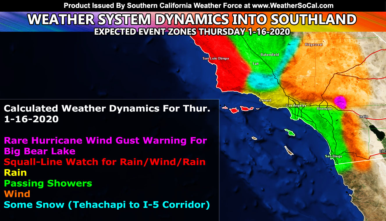
A weather system is due into the region on Thursday into Thursday night. This system will bring a bit of mountain snow and a moderate front Los Angeles westward, weakening for the IE/San Diego areas. The big story is the wind and the rare Hurricane Wind Gust Warning has been issued.
Join Southern California Weather Force main Facebook Page for future updates!
MICRO-CLIMATE ALERT FACEBOOK GROUPS: Find yours today!
Click here to join
Reading for another state? Join my national page – https://www.facebook.com/nwfweather/
This is the first official article of this weather system so it will contain what has been issued, when, and what is next. First, issued a day ago for the Kern County Mountains was the Special Weather Statement and it read; A cold-front will move through on Thursday. This cold front will be the tail-end charlie of a weather system that will affect Central/Northern California more than the Kern Mountain zones. This front will drop the snow-level along it to 4,000 FT so areas in Tehachapi and even the I-5 corridor (Gorman) areas will receive snowfall … It is not expected to be a major event, however it should hit quick and leave quick … escorts are possible on the Gorman Pass with this on Thursday. Upgraded advisories will be issued ahead of the front, along with the snowfall total model …
Then today at noon I went over the wind gust model and determined that Big Bear Lake will see a level 7 out of 8 event, which is a significant wind event on Thursday. I issued over the micro-climate email/app alert system the Hurricane Wind Gust Warning and it reads; A strong mid/upper level jet stream will move through on Thursday giving some snow to the region and strong winds. The snow isn’t going to be the issue here, the winds will be. The mid-level jet is very strong, probably the strongest in a couple years and what this will do is with the drying behind and along the front, cold air surging downward will bring gusts over the 70 mph mark and the level 7 out of 8 for Big Bear Lake on the Martin Wind Gust Intensity Scale means trees are broken or uprooted, building damage is considerable.
Be advised to prepare for this wind storm starting Thursday afternoon and going through Friday morning … Use the model below to see where on the mountain you are to the intensity scale.
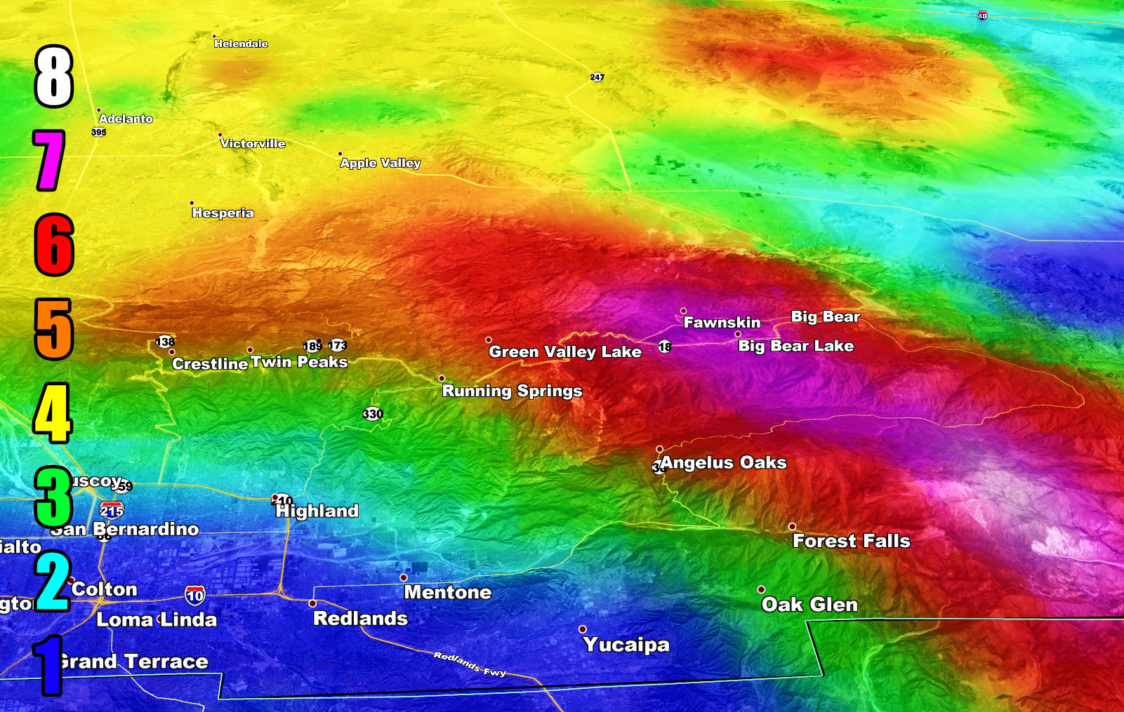
Martin Wind Gust Intensity Scale –
8. Extensive widespread damage.
7. Trees are broken or uprooted, building damage is considerable. – High Profile Vehicle Roll-Over CERTAIN.
6. SOME Trees are broken or uprooted, building damage is possible. – High Profile Vehicle Roll-Over Likely, Do NOT recommend Traveling in this zone
5. Slight damage occurs to buildings, shingles are blown off of roofs. HIGH WIND WARNING CRITERIA – High Profile Vehicle Roll-Over Possible if weight is not corrected.
4. Twigs and small branches are broken from trees, walking is difficult.
3. Large trees sway, becoming difficult to walk. POWER SHUTDOWN THRESHOLD WIND ADVISORY CRITERIA
2. Large tree branches move, telephone wires begin to “whistle”, umbrellas are difficult to keep under control.
1. Small trees sway.
I then issued a High Wind Warning for the Los Angeles, Riverside and San Diego County Mountains along with a Wind Advisory for the High Desert zones in the same areas the winds are blowing today.
Perhaps the higher class one I issued was for you folks in the Santa Barbara and San Luis Obispo County area where the strongest part of the front will move through. The Severe Weather Statement issued reads; A frontal zone will come through the area on Thursday on its way, weakening through LA/OC/IE/San Diego proper. However as for the statement zone, expecting this front to have somewhat of a punch to it. The front will have gusty winds along with heavy rainfall that is breaching the Flood Advisory criteria at the moment so embedded in this is a FLOOD WATCH. The frontal zone dynamics does have some chance of EF0 tornado capabilities but as of right now this statement is for the further issuance and monitoring of the Squall-line Watch, which means gusty winds along the heavy rainfall is expected in this zone with the strongest in the Western SBA County zones up into SLO County … Use the model below for the wind expectancy in your area …
As for the rest of the OC/IE/San Diego zones. This frontal zone is weak and you can expect more rain in the Ontario/SBD/Yucaipa zones than say Lake Elsinore/South OC and even San Diego where weaker amounts will be expected. I’ll have full rainfall forecast maps available just before it hits but your timing for this is Vandenberg/SLO at 4pm, Ventura and Bakersfield at 7pm, Los Angeles and Tehachapi at 10pm, and overnight for the IE/OC/San Diego zones with mid-morning exits last through San Diego’s Mountains. It will vanish without a trace at the RIV/San Diego Mountains so the low desert will not see a thing from this rain-wise.
The preliminary Flood Risk Model shows an advisory level issuance possible for the Ventura Coast/Basin and some SFV/SCV locations with the passage of this front before weakening fast over the IE/OC/San Diego areas. Monitoring will resume Wednesday for an alert issuance in those areas but the wording here will stand …
As for the Cajon Pass, I do not expect accumulating snow on the pass on Thursday night. There will be reports of flakes falling, but it will not accumulate up there. The means snow level for the RIV/San Diego Mountains will be around 5,000 – 6,000 FT … Snow models will come before the front arrives, but it will not be a strong event at all.
All articles and micro-climate alerts can be delivered to you via the app/email alert service subscription so Click Here To Check It Out And Join Today and NEVER miss a beat
MICRO-CLIMATE ALERT FACEBOOK GROUPS: Find yours today!
Click here to join
As always, stay tuned to official forecasts from Southern California Weather Force for updates …
For The Main Weather Facebook Page Click Here and Join.
End Article
FACEBOOK PAGES TO JOIN!
SOUTHERN CALIFORNIA WEATHER FORCE MAIN: Southern California Weather Force Office Main Page
BEHIND THE SCENES FORECASTS/UPDATE PAGE: Southern California Weather Force Meteorologist Page
FOR THE CALIFORNIA FAULT STRESS MODEL PAGE: For SCWF official updates to the California Fault Stress Model and more!
“PONDER THIS” SCIENCE ADVENTURE SHOW: A science adventure show developed here at Southern California Weather Force that is a fun ride!
INSTAGRAM AND TWITTER ACCOUNTS TO JOIN!
Instagram – https://www.instagram.com/socalweatherforce/
Twitter – https://twitter.com/SCweatherforce