Southern California Weather Force has officially upgraded the La Nina Advisory to a full La Nina Warning with an expected strong La Nina this winter season so read on for details on what this could mean …
Join Southern California Weather Force main Facebook Page for future updates!
Back in May of this year I released an article stating a La Nina Watch had been issued here at Southern California Weather Force. You can read that article by CLICKING HERE. The article wording has hit the nail on what Summer 2020 was and also what will be expected and here is the article quote from May 2020; ”
LA NINA WATCH ARTICLE OF MAY 2020 – Other agencies expect this to be a hiccup and that we will likely see a neutral season coming up, which is neither La Nina or El Nino. However, trends on my calculations are certainly showing up as much stronger of a La Nina signal and this will happen as early as this Summer as cold water up-welling occurs west of South America with a weakening of the trade winds.
Summer 2020 as a result will have far more Atlantic Hurricanes and fewer Pacific Hurricanes. What that means for us is that the lack of Pacific Hurricanes will keep the pressure systems from developing
However the position I expect the monsoon ridge to be in may actually make us in Southern California have an average and even below average monsoon season. We will need to rely on moisture from the Gulf of Mexico to be sucked westward into our region with the increased Atlantic Hurricanes I expect. This is a long-shot and most of the moisture as a a result will stop in Arizona and curve into Utah and Nevada.
As for the Winter Season, a Strong La Nina in my forecast means a much colder winter to come so after this coming ‘Summer’ many may welcome the cold again.
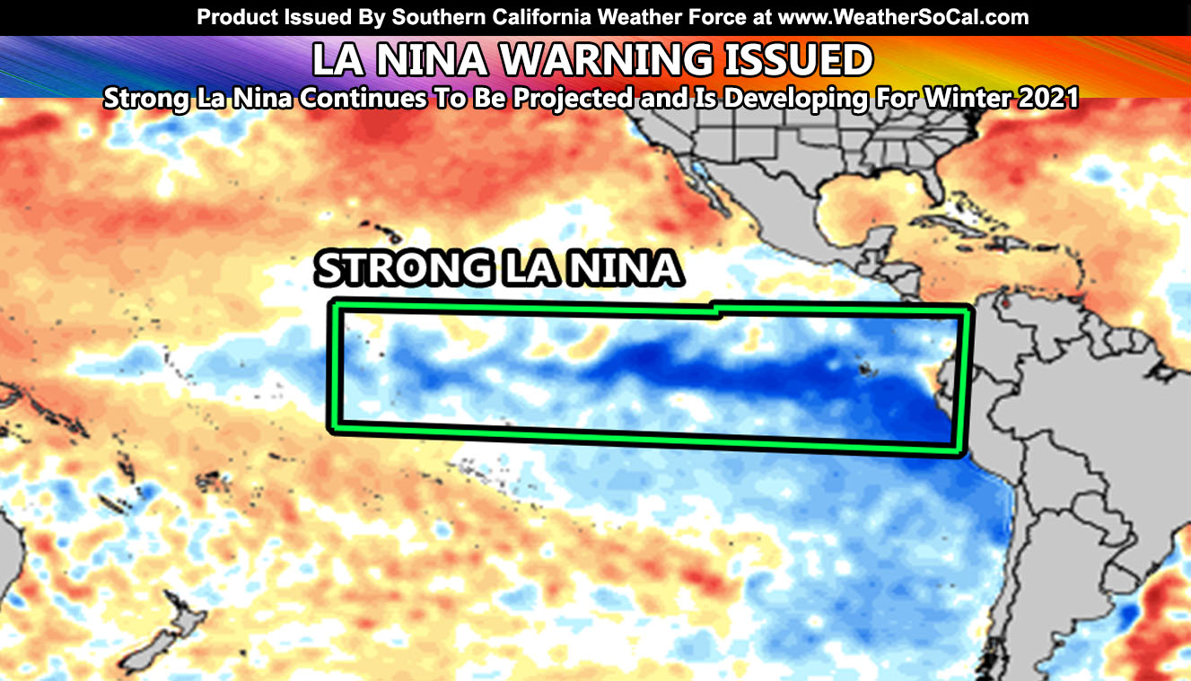
As you can see, other agencies at the time of the May 2020 forecast clearly stated a neutral season while my calculations went with a stronger La Nina. As you can see from the current sea surface temperature map within this article image, it is a very strong La Nina developing, possibly the strongest in quite some time. But what does this mean for our Fall, Winter, and Spring? This type of La Nina may make it out as the dreaded 2017-2018 or 1971-1972 season where we were below average in rain and much colder. Now I know many of you will welcome the cold this winter, but the cold comes with a price, and that price is drier than normal conditions. Now how is this bad you ask? The drier than normal conditions does not mean that we will see no storms. This is actually pretty bad for us because the storms that happen in Fall, Winter, and Spring will be strong when they do finally show up and this is not what we want for flood conditions.
The storms of Winter and Springs 2018 that killed many people in Santa Barbara/Montecito are in the cards this next season. The 2017-2018 season was well below average in Los Angeles, however further west it was very deadly. More calculations will be carried out before the final forecast comes out in October, but the preliminary estimation suggests a very dangerous season to come with colder than normal temperatures, drier than normal rainfall, but the storms that do come, even if it is only a couple, will be deadly. Just like the Atlantic Hurricane season. When we have a below normal season there, it only takes ONE storm to impact land and then the entire season then becomes deadly, such the case with Hurricane Andrew in 1992 where the entire 1992 season for hurricanes was way below normal and Andrew came in and caused damage that still exists today.
So like I said, prepare for the coming season because it may only be a couple real large storms that come in. We likely will have an active October, November OR December … and a normal/below average winter/spring with a couple deadly storms. With the recent fires, this is going to be a challenge.
As always, stay tuned to Southern California Weather Force for official forecasts and updates in weather across Southern California
Join Southern California Weather Force main Facebook Page for future updates!
MICRO-CLIMATE ALERT FACEBOOK GROUPS: Find yours today!
Click here to join
Reading for another state? Join my national page – https://www.facebook.com/nwfweather/
FACEBOOK PAGES TO JOIN!
SOUTHERN CALIFORNIA WEATHER FORCE MAIN: Southern California Weather Force Office Main Page
BEHIND THE SCENES FORECASTS/UPDATE PAGE: Southern California Weather Force Meteorologist Page
FOR THE CALIFORNIA FAULT STRESS MODEL PAGE: For SCWF official updates to the California Fault Stress Model and more!
“PONDER THIS” SCIENCE ADVENTURE SHOW: A science adventure show developed here at Southern California Weather Force that is a fun ride!
INSTAGRAM AND TWITTER ACCOUNTS TO JOIN!
Instagram – https://www.instagram.com/socalweatherforce/
Twitter – https://twitter.com/SCweatherforce