
I looked at a lot of data over the last couple weeks and more so over the last couple of days. I’ve concluded that a Super La Nina will act like an El Nino in terms of the rainfall while still maintaining a La Nina temperature profile across the United States. This is something I have not done since 2004 where all forecasts pointed opposite of mine and it ended up being correct on my end. So I’m shooting for the skies again with this so read on for details. If you don’t want to read the scientific aspect of it, just view the images below.
In the beginning of the Fall I was going to go with a typical La Nina, a 1970-1971 type season. I expected September and October to start acting like the season, but it never delivered correctly. All the tele-connections were completely opposite of a true La Nina. What we are seeing now across the United States is a ridge over the Gulf of Alaska, surging cold storms down into the Western United States and eventually the rest of the country, with a warmer temperatures in the Southeast and Eastern part of the country. This happened before only once and what followed was a historic winter storm in Oklahoma dubbed the Halloween 1991 Winter Storm. Such a storm is happening right now in that state as we speak. It is too early for all this to be happening. There is no way the jet stream will remain static like this and it will shift as December, January, February, and March hit. Right now it is a typical La Nina.
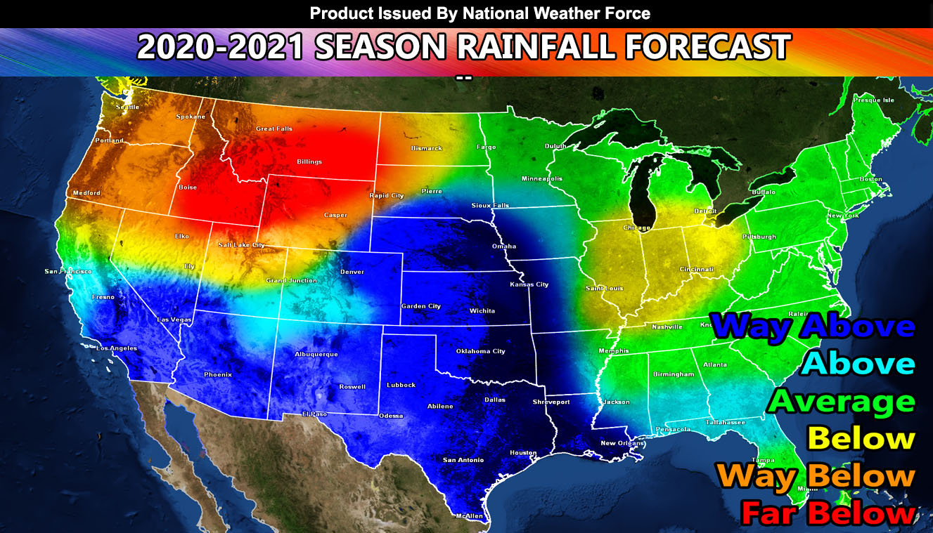
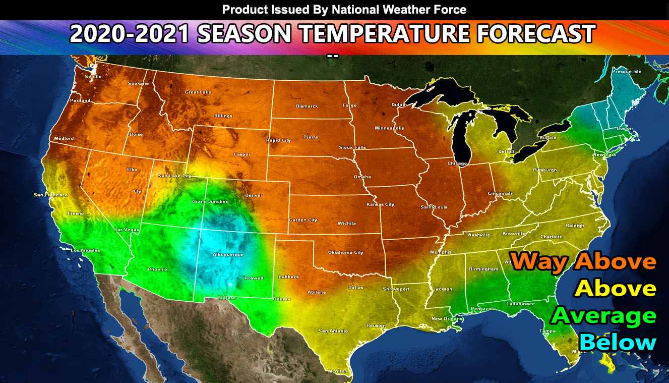
However, I do expect this to shift with the ridge over Alaska to shift a bit west as well. This will drive storms down into the southern tier of the country over the winter with a split type flow pattern across the Northern United States. The end result of this will be wetter than normal conditions across the Desert Southwest and Southern to Central Plains, including the Central and Southern Rocky Mountains. These storms will bring mostly average precipitation across the eastern half of the country as they move through. The temperatures would result in colder than normal in the Southwestern United States and across Upper New England. The rest of the country will be average to warmer than average. This pattern is typical of a La Nina in terms of temperatures, but is an El Nino in terms of precipitation zones. The resulting jet stream I forecast from this would bring a number of tornado events, on such event will be in November, with several impulses with a trough setup over the Western United States and moving into the Central U.S. November will be a month to monitor. Furthermore, the jet stream would provide tornado risk across the Southern/Southeast USA as well at times through the Winter.
REASONING: Back in 2015-2016 we had a Super El Nino. This value has never been breached before and everyone thought it would be a true El Nino year. This actually ended up being a La Nina in terms atmospheric effects. We just don’t know what happens if the ENSO values of El Nino and La Nina get too high. Everything in life happens in moderation so the question is does a Super La Nina get treated like an El Nino since it is a very high value, which by the way will be a record this year once it bottoms out.
I just do not see this as a La Nina profile for winter, similar to what I saw for 2016-2017’s season. Another La Nina that ended up EL Nino in precipitation.
NOTE: Anyone near burn areas of recent… take note that these will cause mudslides so prepare accordingly…
So the article image is the precipitation forecast. The next one is my temperature forecast. These forecasts and this article is exclusive to National Weather Force and may not be worded by any media or competing weather source without permission and credit to National Weather Force with a link back to the Facebook Page. – but ALL public viewers may share this if they wish.
This article was made on the National Weather Force system.
Download the new Android/IOS notification app for instant notification updates to my projects below.
Click here to download – http://www.nationalweatherforce.com/2020/07/07/fb-weather-phone-app/
Facebook Pages On Network –
National Weather Force – https://www.facebook.com/nwfweather/
Southern California Weather Force – https://www.facebook.com/scweatherforce/
Arizona Weather Force – https://www.facebook.com/ArizonaWeatherForce/
California Fault Stress Model – https://www.facebook.com/CaliforniaFaultStressModel/