Southern California Weather Force has issued a Special Weather Statement effective Tuesday as the outflow from a disturbance over Central Baja, Mexico will reach Southern California overnight on Monday, morning early Tuesday morning, and going through the day, upping the chance of showers or thunderstorms for Los Angeles eastward, westward is out so read on for details …
We are having yet another break from tropical moisture in what were ‘surprise’ events within the last week, but another one looks to be brewing. A disturbance currently in Mexico will cross Central Baja, Mexico tonight into Monday. Powerful thunderstorms will develop within it and the outflow from them will be sent northward towards Southern California and Arizona. The last event came from Arizona, but this one will come from Baja, Mexico, which means that San Diego and Imperial County will be within the chance of showers or thunderstorms.
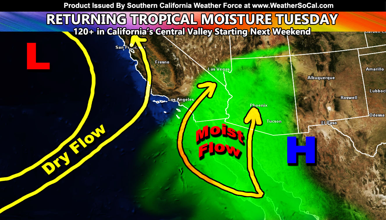
There is an upper-level low west of California that will keep a dry southwest flow west of Los Angeles, so if you are in Ventura, Kern, Santa Barbara, or San Luis Obispo County you are not in this forecast. There will be a fine line from dry air to moist air … the dividing line is Los Angeles County. So Los Angeles is the border of no activity vs activity, with most of it happening east into Orange, Inland Empire, San Diego, Imperial, Coachella Valley, San Bernardino Mountains, High Desert/Morongo Valley, CO River, and Las Vegas, just as the embedded article graphic says.
Depending on mid-level moisture, this could harbor a better chance of rainfall, not flooding type, however. It also does give the risk of fires due to lightning strikes under little rainfall in some of the cells. This will move off by Thursday – so this is a one to two-day event. Stay tuned to Southern California Weather Force on social media, your member e-mail alert service system, or however you follow for further updates.
THE OFFER EXPIRES FOR GOOD JUNE 22ND! – GET EMAIL ALERTS AND ENTER THE MEMBER SECTION ON THE SITE: Both Southern California Weather Force and Arizona Weather Force have a cheap Summer 2021 discount to supercharge this service you already get on social media for free. If you do not want to miss any articles this season because social media does not show you for hours or even days (common) and want to get custom email alerts such as thunderstorm, severe thunderstorm, flood, heat, or tornado alerts along with a controllable member section model for each during the events in YOUR area, sign-up for the premium member package, which is only $10 for the Summer. Read below for details on how to join this offer.
REMEMBER… your continued want for this service is what keeps the server running and paid for. A big bill is coming in the Fall and if I can get enough signed up this Summer, I can extend everyone’s Summer 2021 package through September. Thanks for your help!
SOUTHERN CALIFORNIA WEATHER FORCE – Click here to Join Southern California Weather Force‘s package
Southern California Weather Force Facebook Page is here
SCWF is on MeWe – https://mewe.com/p/southerncaliforniaweatherforce
FACEBOOK PAGES TO JOIN!
SOUTHERN CALIFORNIA WEATHER FORCE MAIN: Southern California Weather Force Office Main Page
SOUTHERN CALIFORNIA WEATHER FORCE METEOROLOGIST: – Just my public figure page that isn’t as large so maybe you can reach me better at times.
NATIONAL WEATHER FORCE – Join my NATIONAL page for higher-end events like flood, tornado, hurricanes, and more –
INSTAGRAM, TWITTER, and NOW MEWE ACCOUNTS TO JOIN!
Instagram – https://www.instagram.com/socalweatherforce/
Twitter – https://twitter.com/SCweatherforce