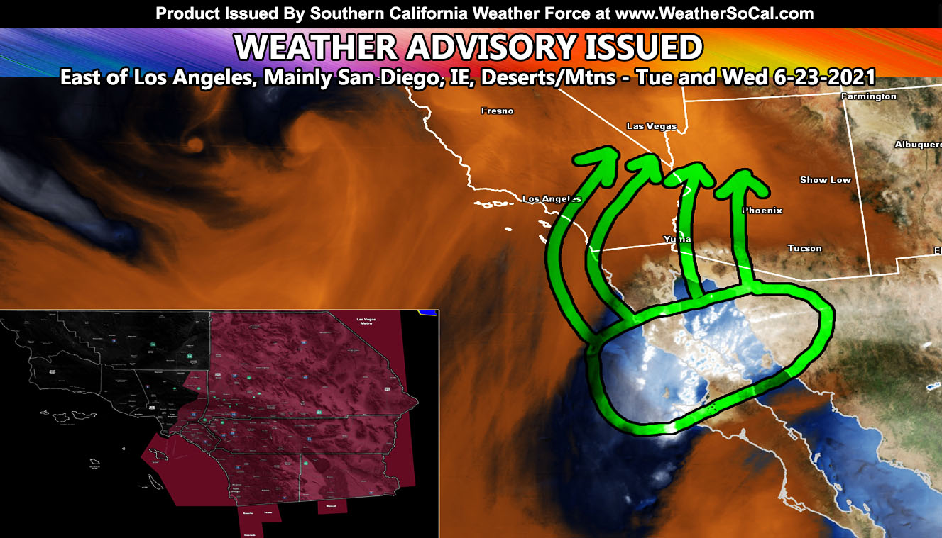
Southern California Weather Force has issued a Weather Advisory for areas east of Los Angeles, Beginning lightly on Tuesday and peaking Wednesday. Areas within this center San Diego, Imperial, Inland Empire, Las Vegas, High/Low Desert, Wrightwood to Big Bear, Riv/San Diego Mountains so read on for details …
In the article image, you can see the circled area. This circled area is the area of moisture being monitored from activity over Central Baja, California. As stated in the previous article (Click here), this would enter the region on Tuesday and last a good 24 hours from then, getting deeper with time. Tuesday has more of an isolated hit-and-miss look to it. There isn’t much mid-level instability to get excited about a widespread event, but we could see some showers and isolated thunderstorms in the advisory area on Tuesday. However, as Tuesday night and Wednesday morning come around, increasing moisture in the mid-levels will make for a widespread shower and thunderstorm event for the advisory area.
An advisory box cannot be made due to the thoughts the entire area will see something … not isolated, more scattered to numerous and it should fill 90% of the advisory shaded zones in the alert system with showers OR thunderstorms. MId-level instability is more than enough to warrant the risk of thunderstorms developing during that time. ACtivity will move south to north and should not go west of Los Angeles County. As stated in that previous article link above, Los Angeles is the border of the dynamic zone.
A weather advisory means that conditions are favorable for showers OR thunderstorms in the advisory zone or that conditions for thunderstorms are borderline and not enough for a full thunderstorm watch on a tougher forecast.
A thunderstorm watch may be issued for Wednesday for parts of the advisory zone if trends continue, the ground zero sections being San Diego north-northeast to the RIV/SD Mountains where the mid-level dryline will exist Wednesday. If a thunderstorm watch needs to be issued on an upgrade, it will be posted on Tuesday evening across the social media pages below, or the premium email alert system, whichever you are on.
OCEAN: If you are planning on being out in a small craft, you will encounter the risk of thunderstorms From east of Catalina and San Clemente Island between Orange and San Diego County’s coastal areas mainly Wednesday –
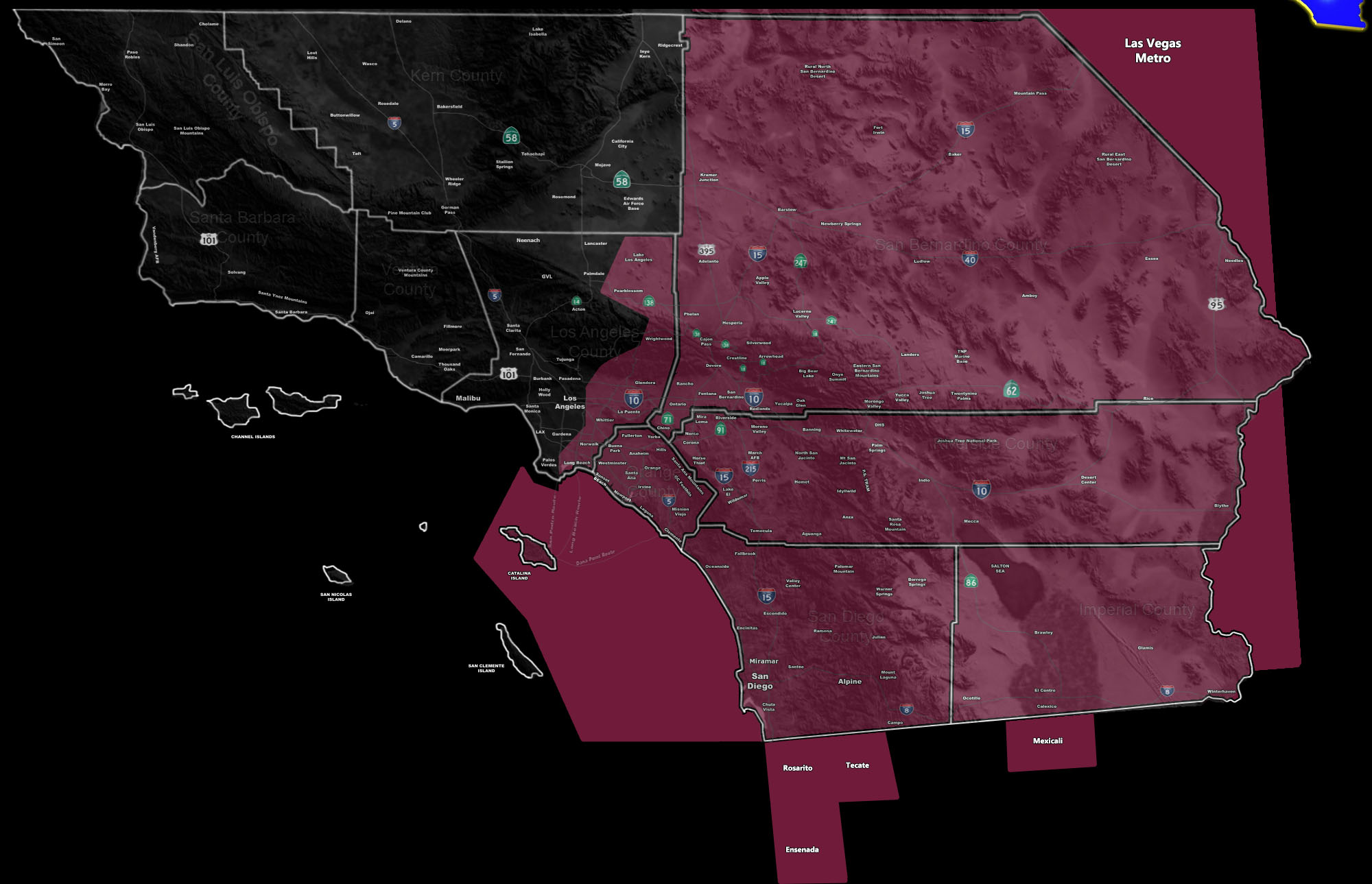
Here is a clickable version of the advisory map showing the city locations within the forecast area under the Weather Advisory.
THE OFFER EXPIRES FOR GOOD JUNE 22ND! – GET EMAIL ALERTS AND ENTER THE MEMBER SECTION ON THE SITE: Both Southern California Weather Force and Arizona Weather Force have a cheap Summer 2021 discount to supercharge this service you already get on social media for free. If you do not want to miss any articles this season because social media does not show you for hours or even days (common) and want to get custom email alerts such as thunderstorm, severe thunderstorm, flood, heat, or tornado alerts along with a controllable member section model for each during the events in YOUR area, sign-up for the premium member package, which is only $10 for the Summer. Read below for details on how to join this offer.
REMEMBER… your continued want for this service is what keeps the server running and paid for. A big bill is coming in the Fall and if I can get enough signed up this Summer, I can extend everyone’s Summer 2021 package through September. Thanks for your help!
SOUTHERN CALIFORNIA WEATHER FORCE – Click here to Join Southern California Weather Force‘s package
Southern California Weather Force Facebook Page is here
SCWF is on MeWe – https://mewe.com/p/southerncaliforniaweatherforce
FACEBOOK PAGES TO JOIN!
SOUTHERN CALIFORNIA WEATHER FORCE MAIN: Southern California Weather Force Office Main Page
SOUTHERN CALIFORNIA WEATHER FORCE METEOROLOGIST: – Just my public figure page that isn’t as large so maybe you can reach me better at times.
NATIONAL WEATHER FORCE – Join my NATIONAL page for higher-end events like flood, tornado, hurricanes, and more –
INSTAGRAM, TWITTER, and NOW MEWE ACCOUNTS TO JOIN!
Instagram – https://www.instagram.com/socalweatherforce/
Twitter – https://twitter.com/SCweatherforce