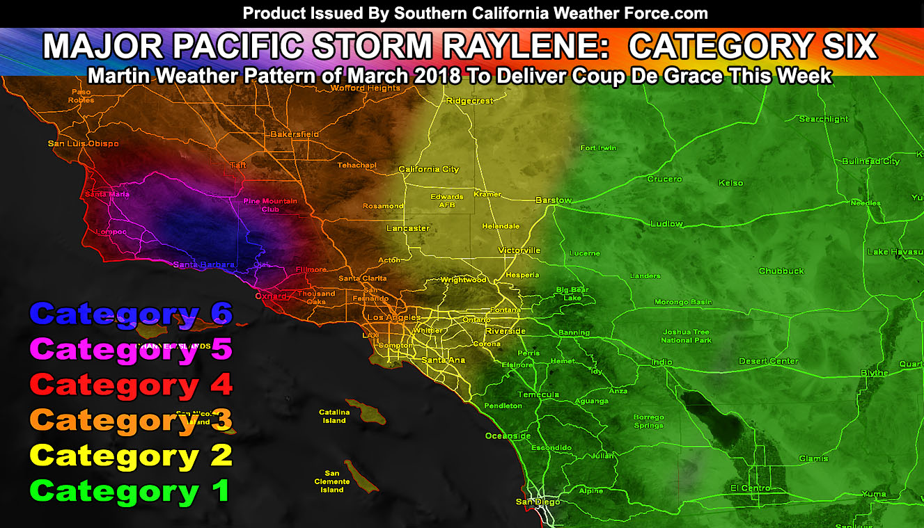
Major Pacific Storm Raylene has been officially upgraded to a category six on my one through six scale for Pacific Storm Rarity and Intensity. The category six is in the Thomas Fire burn areas, southward to where the January 9th debris flows came through. While this is a category six in those areas, it will vary depending where you are just like the center of a hurricane path brings.. you could be on the outskirts of a weaker system .. or right in the middle of the strongest section, so read on for details.
First and foremost let me explain what a category intensity means here at Southern California Weather Force. Back before the year 2000 I came up with a system that labels names and intensities to Pacific Storms that impact Southern California. The system is a private system only used here at this weather service and thousands of viewers have come to adopt it as their official forecast. This link (Click Here) will help you understand the Pacific Storm Intensity levels better. It has a category one through six, with the last category six happening in March 1983 for Los Angeles when a Pineapple Express hit that area hard.
Latest satellite images shows Major Pacific Storm Raylene grabbing moisture from down in the tropics as we speak and getting ready to impact the region starting Tuesday and peaking Wednesday and Thursday. Rain models in the SCWF Member Section continue to show a bulls-eye directly in the Santa Barbara and Western Ventura County area, smack dab in the middle of the Thomas Fire burn scar. This will intensify Tuesday evening and overnight, continuing into Wednesday and Thursday. This is a pro-longed rain event so you should have already prepared for this ahead of my earlier forecast warnings days ago.
If it does not say “Liked” LIKE The Page Below and join thousands of informed weather forecast viewers in our region for more of the updates! noticeable
I am maintaining the 10-15 inch mark so anything at 10 or 15 to in-between is a hit in this forecast for a small area of the Thomas Fire Burn areas. Just because I say 10-15 inches of rain in this storm does not mean you will see it. Coastal zones could have over 5-8″ of rainfall for the Ventura and Santa Barbara zones, however just a bit inland on the southern slopes of the Santa Barbara and Ventura Mountains will be the small zone of 10-15″ of rain, which will come down the mountain as a lahar toward the ocean.
As for the rest of the forecast area .. Los Angeles will remain in-between not so much rain to deadly flooding ..so just to be happy and get a soaking is what I would say. The category chart shows the category six system is ONLY for the Thomas Fire burn scar southward to the ocean with the coming lahar; or debris flow. Los Angeles will remain in a category 2-3 intensity for rainfall with some wind gusts to speak of out there. Further east into the Inland empire you’ll be split between category 2 intensity along the I-15 corridor to category one closer to Hemet, Banning, and Temecula; which means (as I stated before) that you are not going to see the intensity that further west of you will see. San Diego you are going to see the weakest amounts of the system for the metros with a weakening front moving through later on Thursday.
There is a chance of isolated thunderstorms in the category three sections of Los Angeles, Ventura, Santa Barbara, San Luis Obispo, and Kern County on Thursday when some instability tries to move in. This shouldn’t be a widespread thunderstorm event simply because this is a tropical laden atmosphere and the lack of stronger instability (cold air aloft) would preclude static charge within the cloud on the level of any concern.
Snow levels remain high with this system so no snow products will be issued, nor will the snow models be updated.
As for other areas of interest outside of the forecast area, Mammoth Mountain’s base is just around 8,000 FT and this is around where the snow-level will be up there for this storm, with a slight push to 8,500 FT. Still, with fluctuations, can see 1-2 FT of snow up there with over four feet of snow at the top.
The Sacramento Valley is something of a bit of interest from me as well. Wednesday and Thursday have enough instability and shear for severe thunderstorms to form, some of them with larger hail and even the risk of tornadoes. So if you live in the Sacramento Valley areas … keep this in mind.
Click Here To Find Your Zone On Facebook For Updates Now and In The Future
Click Here To Find Me On TWITTER.
If it does not say “Liked” LIKE The Page Below and join my main weather office page that gives you updates during the events and insights from my weather office that the other pages do not give.