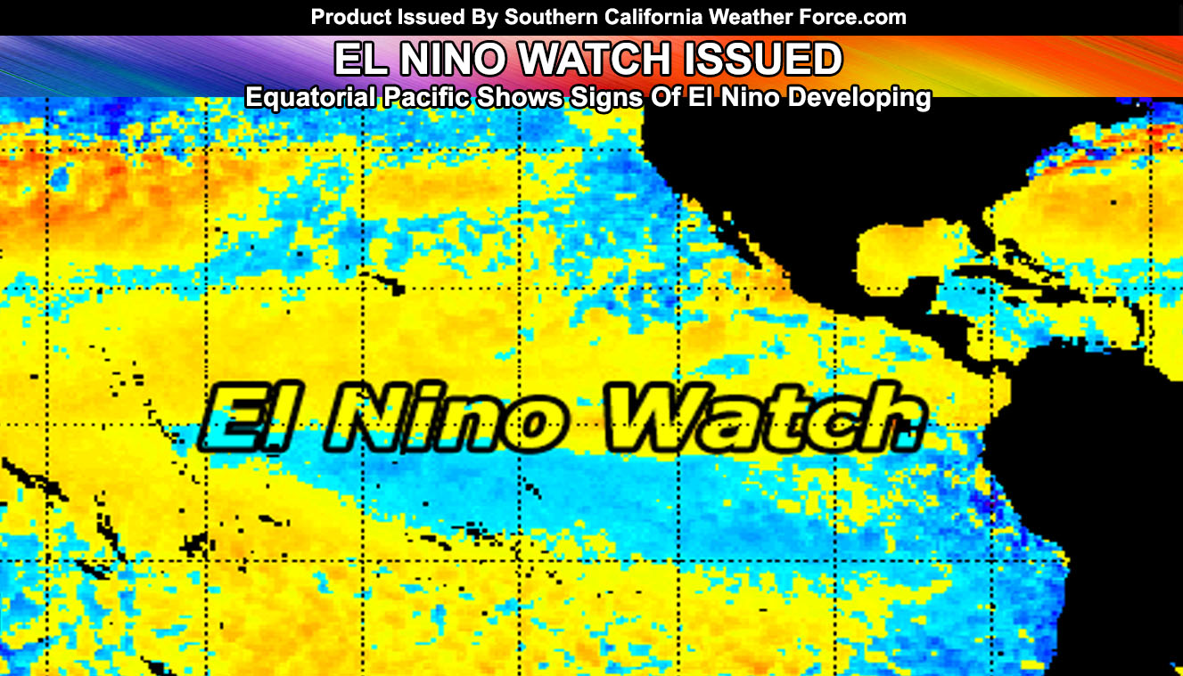
The waters of the equatorial Pacific are warming this Summer and the stage is being set for El Nino to develop more as we head on into Fall season. Read on for details on what this could mean.
The average of the last few months and the projection of the next has several analogs to it. One of them being 2004. This is giving somewhat of a hint on what can be expected should El Nino continue to develop. We do not want another major El Nino like the one a few years back. That El Nino had the Martin El Nino Anomoly with it. The Martin El Nino Anomoly was a batch of warmer water west of Southern California and this shoved all the needed rain north into the Pacific Northwest down to Northern California. It brought a parched ‘rainy’ season with it even though it was classified as a ‘Super El Nino’.
Ongoing Text Ad: Furthermore we parted with our main summer-time advertiser and will need help from viewers/readers this Summer. So if you are interested in helping you can donate to SCWF in just a couple clicks by CLICKING HERE. I do appreciate all the help to make it through this Summer Monsoon Season. We are now over 1/2 to the goal and on the way to 3/4 to keep operations this Summer without an advertiser. Thank you everyone who has helped thus far. If the monsoon kicks up in July you’ll want to have this service operational.
Over the years I’ve notice El Nino and La Nina seem to be wildcards for our weather down here and do not detonate what we will really get. However, recent discoveries I am doing is cracking the code on what gives us better storm seasons, including the lack of warmer water in the Northeast Pacific and West of California. This warmer water creates a surface ridge and makes storms move around them and we end up with a drier northwest flow.
We had a weak La Nina last year, a weak La Nina the year before and a Super El Nino before that. All were officially as El Nino and La Nina with different rainfall for each. It is an OCEAN thing NOT a weather thing. Article states completely that.
A major misconception people have is when La Nina is mentioned they automatically think drier than normal and El Nino is wetter.
It takes a type of El Nino or La Nina to give us the best rainfall and one to limit it. Usually between Weak-Moderate El Nino is very good for us, which is what we are heading for. Explanation is in the article so don’t just read the title.
Unless you want me next time to clickbait generate a title of “EL NINO HAS FORMED PREPARE NOW OR DIE” always read the articles posted. I won’t be blamed on anything if you do not take the time to read.
This year’s El Nino will be Neutral to Weak/Moderate by the time winter hits. El Ninos that are weak have produced some of Southern California’s best rainy seasons, including that with the 2004-2005 season where we ended up with well over 30 inches of rain in Los Angeles and the recent 2016-2017 season with 19 inches of rain, which was technically neutral. We’ve also had weak El Ninos that failed to produce, such as 2006-2007’s season with just under 4 inches of rainfall. Then you have the strong La Nina of 2010-2011 with 20 inches of rainfall. So you can see what I am saying is that El Nino and La Nina do not 100% mean we will be dry or wet.
So what does this all mean?
If we get a Weak El Nino the following percentages are in play;
20% chance way drier than normal
20% chance slight drier than normal
20% chance near or average
10% chance record dry
10% chance slightly above average
10% chance way above average
10% chance near or record
If we get a Moderate El Nino the following percentages are in play;
42% chance way above average
29% chance slightly above average
29% chance slightly drier than average
SOUTHERN CALIFORNIA ONLY: if it does not say “Liked” LIKE The Page Below and join thousands of informed weather forecast viewers in our region for more of the updates! noticeable
As you can see our best above average rainfall chances happens with a moderate El Nino. If we blend the numbers the odds are even better so between a Weak and Moderate El Nino may be preferred as chances for a drier season diminish as we near Moderate El Nino. We should push to weak El Nino by at least September and should this happen we have room left to push up to the wanted moderate.
We have no signs of the warmer waters in the Northeastern Pacific Ocean or West of California thus far so prospects are gaining that this won’t be an issue.
Stay tuned to Southern California Weather Force for further information over the Summer.
BEHIND THE SCENES FORECASTS/UPDATE PAGE: if it does not say “Liked” LIKE The Page Below and join thousands of informed weather forecast viewers in our region for more of the updates! noticeable
Things to note are as followed;
- A colder than normal Summer does not mean we won’t have times of a heatwave or two. It means overall it’ll be colder than normal.
- Tornado activity will remain this Summer in the desert and Central/Eastern Inland Empire areas. Thunderstorms elsewhere likely …
- Monsoon Season starts June 15th, however this year will be a mid-start, likely toward or in July.
- To remain active this Summer we are keeping the member section open to the public but as a ‘donation’ for help, by Clicking Here you’ll help this service remain into Summer.