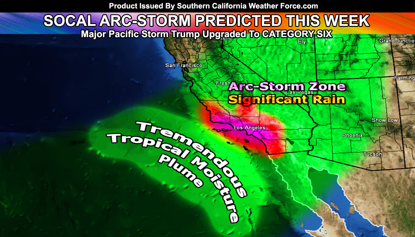
As I have warned you since last month, you should have been prepared now in the burn areas and even mudslide zones. I have officially upgraded Major Pacific Storm Trump to a Category SIX, the highest in the 1-6 category I developed and only used every five to 10 years. The combination of middle snow levels early week and tropical levels over 9,000 to 10,000 Feet melting all that below it and sending it downstream into the metros and burn areas will make this event one to remember and the most dangerous since March 1983. Read on for details.
First and foremost I’d like to go over the first part of Major Pacific Storm Trump. The first impulse hit last night and early this morning across Southern California. It is ongoing through the evening at the time I am writing this with some thunderstorms being reported. This will move off later this evening very quickly as upper convergence moves into place.
Things to note that went correct in the forecast article that you can read by Clicking Here.
- Not issuing winter weather advisories for 4 inches of snow or higher (my criteria) was correct. The mountains didn’t see too much and I left it at that because of the offshore flow component.
- Thunderstorms along the front in a short term update on the main Facebook Page was correct in the correct area as OC and San Diego got hit early Saturday morning. Click Here for that update.
- Flood warnings and advisories were placed in the exact areas they should have been. Prediction of the front weakening as it moved inland also was correct due to the same offshore flow component.
- Morning update stated post-frontal zone shower and thunderstorm activity would happen.. it did.
- Prediction of the low and high desert receiving this with not much rain-shadow influence was correct. Some of that ongoing as I type this.
- I am the one that predicted the Montecito flooding disaster last year way ahead of time. I would LISTEN TO ME IF I WERE YOU
This is telling me that I am in-tune to this coming pattern and the coming forecasts will be extremely accurate. They also will have wording some may never have heard before. The coming systems will have it all.. from damaging frontal zone winds to actual tornadoes over the land. I will be issuing severe thunderstorm products and even tornado alerts when needed.
MAJOR PACIFIC STORM TRUMP UPGRADE TO CATEGORY SIX: – Click here to read how I do the category systems
On Monday the next impulse hits the region. This one will be stronger than the one we just had. The parent upper level low is going to swing multiple impulses over the week and we will be the catcher’s mitt on every single one. Where the strongest rains will hit will be a medium/short term thing however anywhere south and west of the mountains, including the mountains has a shot at significant rainfall over the course of this next week. Monday’s will have a surface low which will angle the surface winds from southeast to northwest like our first one did. This will bring snow levels to 6,000 FT for sticking snow.. maybe as far as 5500 and 5k wet non-sticking. This system’s time-frame is definitely Monday morning into the evening. Most systems happen at the dead of night however this one will be mostly a daytime system. Daytime systems have stronger instability so severe weather potential is there. Frontal zone winds will also be stronger.
The next system hits Tuesday and stands to be one of the strongest impulses of the round. This one could have snow levels bumping to 7,000 FT. This means that warm-air is starting to advect in from the tropics and this is when it gets dangerous. Dynamics with this remain severe.
The final impulse hits on Thursday, probably over the day is where I’m going with this one. This one will also be one of the stronger ones. Snow levels with this are worrisome. 10,000 Foot snow levels means that any snow between 6k and 10k will be melting and it will send it downstream to create massive flooding problems in the metro/coastal plains, including all burn areas and not only limited to those areas. The ‘arc-storm’ of California in the 1800s had a similar effect with the Sierra Nevada on a larger scale. It snowed a lot in the beginning and then the snow levels started moving up to 10,000 FT (tropical level) and it melted the Sierra Nevada snow and sent it downstream into the populated zones of the San Joaquin Valley, devastating the area in floods. Same likely happened down here. It was a large scale event in California.
Since this is a regional event down here in Southern California, the same is likely here. You need to prepare for it not only if in the burn areas.. but near any river or runoff. Because of the combination of severe weather, flooding rains, and rarity of such a pattern on snow level fluctuation, I have officially upgraded Major Pacific Storm Trump to a CATEGORY SIX system out of the 1-6 scale.
The CATEGORY SIX zones will be the Santa Barbara, Ventura, Los Angeles, San Bernardino, Riverside Mountains. It also will include all metro and coastal zones of Santa Barbara, Ventura, Los Angeles, Orange County, east to the Inland Empire areas.
Because of the lack of 10k peaks in San Diego for major run-off and the angle of the systems coming in … You will remain at category five conditions.
PREMIUM MEMBERS: You will get your alerts and updates. Also if a SBCGLOBAL (ATT) member for e-mail I have fixed the block problem with their security team. You will not receive alerts from me. If you are NOT a member? Search below on how to receive custom alerts via your e-mail and view the custom model maps during events.
End
NOTE: Premium members. If you are signed up, your login is your e-mail address and the username and password as the password. You can change the password
Ongoing Ad – The Southern California Weather Force has a member section with LIVE UPDATES FOR EVENTS and rain, wind, thunder, tornado etc models that are personally updated by me with each Santa Ana Wind or storm event. You also can get e-mailed alerts via a slew of micro-climates. Check the member section for details on how you can support this service.. along with getting service in return… Click Here To Join or Upgrade Via The Member Section
Please remember if upgrading to CANCEL YOUR PAYPAL PAYMENTS. Login and cancel the reoccurring payments.
The Southern California Weather Force has different Facebook groups that you can ask for notifications from in order to get the latest posts affecting those regions. If that area is talked about in an article, alert, and such .. it’ll be posted there and you can be notified.
Comments are usually DISABLED as we do like to keep this as an information giving group and replies from others in the notification may annoy some.
Find your micro-climate group here – https://www.southerncaliforniaweatherforce.com/scwf-weather-alert-facebook-groups-by-region/
EMAIL ALERTS? Many micro-climate zones to choose from to get custom alerts from thunderstorm, wind, flood, surf, heat, cold, storm, and much more with the premium e-mail alert system, the most advanced zone alert system in Southern California – Click Here To Join!
SOUTHERN CALIFORNIA ONLY: if it does not say “Liked” LIKE The Page Below and join thousands of informed weather forecast viewers in our region for more of the updates! noticeable
BEHIND THE SCENES FORECASTS/UPDATE PAGE: if it does not say “Liked” LIKE The Page Below and join thousands of informed weather forecast viewers in our region for more of the updates! noticeable