Major Pacific Storm Trump is a category six system on the Southern California Weather Force 1-6 scale. It will rain non-stop in many areas surrounding Ventura, Santa Barbara, and Los Angeles until later in the week. This is the ‘arc-storm’ pattern that will bring dangerous and deadly mudslides to the burn areas and in some cases non-burn areas in mudslide zones. Tornado Watch will continue to be needed mixed in with thunderstorm products so read on for details on what to expect.
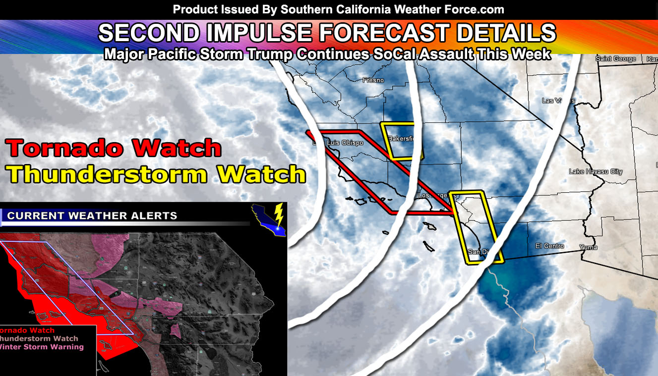
Lightning detection has detected a single lightning strike in the Pasadena foothill areas this morning. As the daytime heating moves along we will see more thunderstorms pop-up. I have issued a Tornado Watch for the following areas from NOW UNTIL THURSDAY; Coast and Basin areas of San Luis Obispo, Santa Barbara, Ventura, Los Angeles and Orange County … A strongly negative-tilted shortwave low pressure system that is Major Pacific Storm Trump (Category 6) is located west of Central California. This wide trough base is allowing for an area of large upper ascent (divergence) aloft. This divergence will overspread the area later this morning and into the afternoon. Instability profiles with the daytime heating will be enough to produce thunderstorms. SCWF Tornado Model is indicating these storms to produce tornadoes. At the surface … A surface low west of Central California is bringing in very strong southeasterly winds across the Tornado Watch zone. . These winds will strengthen as the line of thunderstorms and embedded supercells moves through. With the instability and this southeasterly component atop a jet stream from southwest to northeast creating shear, supercells containing tornadoes are going to be possible. The most likely area will be from Ventura County westward through Santa Barbara and San Luis Obispo County, with elevated values in the LA coast/basin zones as well, as far southeast as Huntington Beach/Costa Mesa … but since all of OC is close enough to the area of upper divergence and thunderstorm risks.. I will issue it for you as well. In addition to the tornado risk, damaging winds and some hail will be likely along with torrential downpours that can lead to flooding …
Furthermore I have issued a Thunderstorm Watch for the areas not within my tornado watch zone but does have the dynamics for thunderstorms to form in the following zones; Kern Valley … Western Inland Empire … San Diego County Coast/Valley … This divergence will overspread the area later this morning and into the afternoon. Instability profiles with the daytime heating will be enough to produce thunderstorms. Two separate areas in my thunderstorm watch box will have thunderstorm risks. The most potent will be the line of storms that will form offshore OC/San Diego and move inland across the watch area. Gusty winds will accompany the front. This watch is to the east of the SCWF Tornado Watch, was is in effect through today.
My Winter Storm Warning is also in effect for the following mountain zones; As stated in the previous article (Click Here), the second impulse with Major Pacific Storm Trump will hit over the day on Monday (Today). Heavy snow is in the forecast for the Kern County Mountains above 4,500 FT, impacting the Gorman Pass as well. Furthermore across the LA/San Bernardino Mountains we could see 1-3 inches of snow at 5000 FT, a dusting at the Cajon Summit, and 6-12 inches above 6,000 FT, including Big Bear and the Rim. Idy/Pinecove you have 3-6″ possible but more likely on the lower end of that… still you’ll be included in the warning. Another impulse hits on Tuesday and more hit throughout the week. Snow levels will rise to over 7,000 FT by mid-week so some communities will see melting snow and mostly rain falling. Premium members can check the snow model in the link below –
DESERTS: There is enough deep-layer moisture to bring rainfall to ALL desert locations of Southern California. No one should be left out of the precipitation due to the deep-layer moisture.
The next impulse arrives on Tuesday, followed by yet another near Thursday. Both of the next impulses will target the Burn areas, however the most dangerous being the Ventura, Los Angeles, and Santa Barbara County zones on all accounts like my earlier forecasts said days ago. Those were always the most troublesome spots.
We dry-out through the end week into the weekend but between January 21st and 23rd an inside slider moves in and this would drop the night-time temperatures once again for a brief period of time. No doubt freeze warnings and frost advisories will be needed then.
As always.. stay tuned to Southern California Weather Force for updates. And if you are NOT a premium member.. you can get e-mail alerts for these articles and the micro-climate alerts when you sign-up today. Look below on how to do that.
End
NOTE: Premium members. If you are signed up, your login is your e-mail address and the username and password as the password. You can change the password
Ongoing Ad – The Southern California Weather Force has a member section with LIVE UPDATES FOR EVENTS and rain, wind, thunder, tornado etc models that are personally updated by me with each Santa Ana Wind or storm event. You also can get e-mailed alerts via a slew of micro-climates. Check the member section for details on how you can support this service.. along with getting service in return… Click Here To Join or Upgrade Via The Member Section
Please remember if upgrading to CANCEL YOUR PAYPAL PAYMENTS. Login and cancel the reoccurring payments.
The Southern California Weather Force has different Facebook groups that you can ask for notifications from in order to get the latest posts affecting those regions. If that area is talked about in an article, alert, and such .. it’ll be posted there and you can be notified.
Comments are usually DISABLED as we do like to keep this as an information giving group and replies from others in the notification may annoy some.
Find your micro-climate group here – https://www.southerncaliforniaweatherforce.com/scwf-weather-alert-facebook-groups-by-region/
EMAIL ALERTS? Many micro-climate zones to choose from to get custom alerts from thunderstorm, wind, flood, surf, heat, cold, storm, and much more with the premium e-mail alert system, the most advanced zone alert system in Southern California – Click Here To Join!
SOUTHERN CALIFORNIA ONLY: if it does not say “Liked” LIKE The Page Below and join thousands of informed weather forecast viewers in our region for more of the updates! noticeable
BEHIND THE SCENES FORECASTS/UPDATE PAGE: if it does not say “Liked” LIKE The Page Below and join thousands of informed weather forecast viewers in our region for more of the updates! noticeable