You had your warning of the return of the pattern for over 10 days now. I am seeing many forecasts saying yes and no and no one seems to want to commit to one thing yet. Well, that is not what I am about and the pattern is correct for the atmospheric river to enter Southern California by the middle of this next week and last into the weekend, which could be a prolonged event. Flooding and damaging winds for downed poles/trees will be likely. A look at your Saturday forecast inside so read on for more details …
First I’ll say a weak front has made its way into the Vandenberg / San Luis Obispo areas this evening as the earlier article projected (Click to read that). This will move across the Kern Mountains and bring a dusting to Tehachapi later on and flurries to Gorman. Keene and Bear Valley Springs will see 1-3″ as per my snowfall model.
This front will arrive in Los Angeles on Saturday morning, very early. The front is expected to hit the Wrightwood and Cajon Pass areas around 4 am or 5 am and the snow-level charts here at Southern California Weather Force show a brief snow level at the top of the pass for a dusting of snowfall. Wrightwood you’ll get 1-3″ of snowfall and Mt. Baldy, Ontario, and Cucamonga Peak will get the 3-6″ margin. The front makes its way into Big Bear shortly after with only a dusting expected. Being it is a quick mover like the previous system, the RIM will receive more than Big Bear, which is tucked in the back where moisture is tough to come by in these setups, and not so for the Crestline/Running Springs zones along I-18 on the RIM. Still, will go with a dusting to an inch in Crestline with 1-3″ in Running Springs and Green Valley Lake to 3-6″ on Mt. San Gorgonio’s Summit.
The Riverside Mountains are in the 1″ mark for Mountain Center and 1-3″ for Idyllwild. Only the summit of the San Diego Mountains is expected for a dusting like around Mt. Laguna and Palomar.
The rest of the area will get a round of precipitation, but it is not expected to be much nor will I need advisories for flooding.
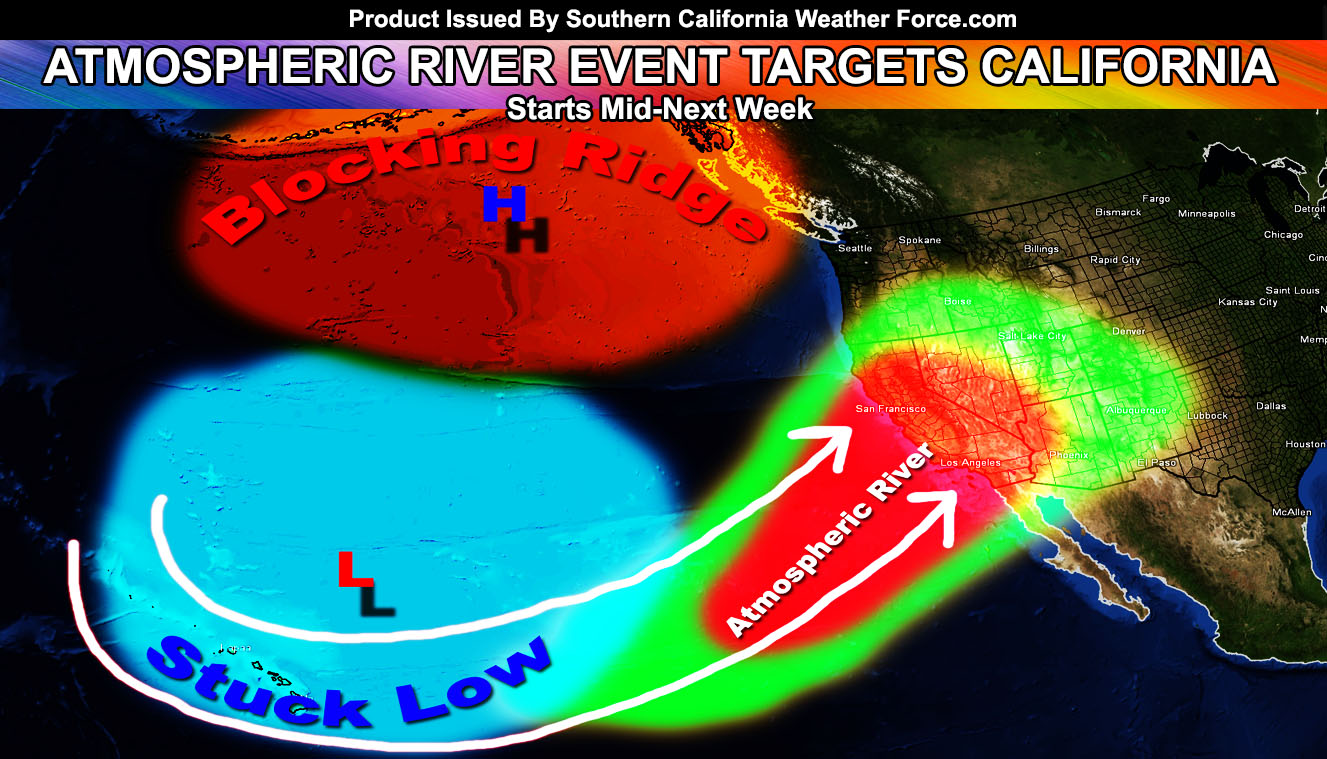
Now onto this mid-next week. Why am I confident in the atmospheric river impacting us? The pattern at the current time does favor it. There is a ridge of high pressure out over the Eastern United States and with the PAC NW getting clobbered on a system making its way here by Sunday for a dusting in the High Desert means there is a ridge in the Gulf of Alaska. That ridge is going to block the system north of Hawaii and it would stay in place to pump tropical moisture into our region by mid-next week. That general pattern is how a Pineapple Expresses into California happens. The ridge out east is blocking the low pressure over the PAC NW from going further east and this will help draw that moisture in soon. Overall the pattern favors an atmospheric river into CA with snow-levels over 10,000 FT to start, by end week they’ll go to resort levels toward the end of the pattern, but it shouldn’t amount of much as this is mainly a tropical laden atmosphere for high snow levels.
In addition to the flooding, damaging winds will be likely, similar to Major Pacific Storm Vladimir. Vladimir had strong low-level winds and the same can be said for what will be named XAVIER. Downed poles/trees will be likely once again due to the combination of rain and wind.
With the lack of due south to north flow like previous systems, a west-southwest to east-northeast low-level flow will highly favor San Diego County with orographic lifting, therefore heavier precipitation and damaging wind potential with the system.
There are indications it’ll come in two parts, the next arriving after that over the weekend. Regardless, I am not seeing any chance from my original assessment of the pattern at this time. Remain with your preprations.
As always, stay tuned to Southern California Weather Force for further details.
For Main Facebook Page Click Here and Join.
End Article
NOTE: Premium members. If you are signed up, your login is your e-mail address and the username and password as the password. You can change the password
The Southern California Weather Force has different Facebook pages that you can join for a better in-depth analysis of storm and wind events …
Click here to find your area today!
EMAIL ALERTS? Many micro-climate zones to choose from to get custom alerts from thunderstorm, wind, flood, surf, heat, cold, storm, and much more with the premium e-mail alert system, the most advanced zone alert system in Southern California – Click Here To Join!
SOUTHERN CALIFORNIA ONLY: if it does not say “Liked” LIKE The Page Below and join thousands of informed weather forecast viewers in our region for more of the updates! noticeable
BEHIND THE SCENES FORECASTS/UPDATE PAGE: if it does not say “Liked” LIKE The Page Below and join thousands of informed weather forecast viewers in our region for more of the updates! noticeable