It wasn’t so much ground fog as even cameras in the area shows a five mile visibility, but it was a tall cold-front that caused the pilot for Kobe Bryant’s helicopter to become disoriented and panic, that of which caused him to hit the hillside last Sunday so read on for the details.
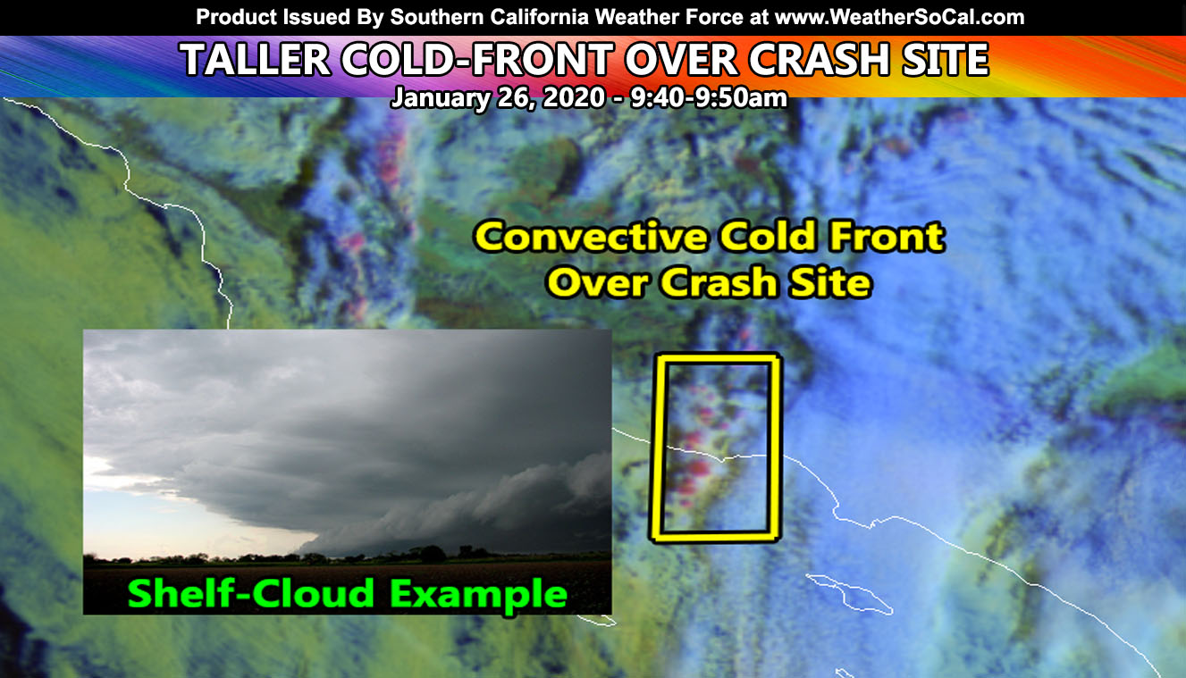
Satellite images obtained here at Southern California Weather Force (article image) prove without a doubt that the cold front was right over the crash site at the time. The pilot was going through the canyon, following the 101. What the question on everyone’s mind is why did he climb to 2,200 Feet on a U-turn to the left before quickly descending, ending up slamming into the hillside just above 1,000 FT. We all know from the neighborhood videos that there was no problem with the engine and everything sounded normal in the final moments.
Based off satellite images, the ‘redder colors’ in the image provide shows ‘convective’ cloud tops. That means that cloud tops were over 8,000 FT thick along the surface cold front easily visible over the area at the exact time. Because of the convective nature you would expect micro-burst activity. However, this was not the case as ground truth had no gusty winds. What likely happened was as the pilot was going through the canyon, scud/shelf clouds along the leading edge of the cold front extended below the 1,800 FT Above Sea Level ceiling. Seeing how low they were hanging caused the pilot to make the decision to turn back the other way and make a sharp ascent to 2,200 FT thinking he would clear the cloud deck.
But as you can see on the satellite image, the cloud tops were much higher and he finally realized this at 2,200 FT when he did not pop out of the top of the deck and became disoriented, continuing the U-turn while trying to descend below the cloud deck again. As the scud/shelf cloud extending to just 200 FT below the ground moved east, it caught up with him and blinded him where he finally popped out and tried to correct the aircraft and hit the canyon at a high rate of speed.
Images at the site show this lowering and 15 minutes later the top of the 1500 FT hill was easily seen, meaning this was a shelf or scud cloud. Had the pilot remained on course westward into the cloud he would have popped back out in 30 seconds over the Thousand Oaks area, west of the cold front and would have made it to their landing destination. The panic of turning back around under a solid cold-front and misjudging the cloud tops, and descending fast to see again was what ultimately brought them down.
Scud/Shelf Clouds are not on airport METAR data and sometimes they don’t form until they get into a canyon. It was something that could not have been predicted.
In conclusion, based off the ending flight profile and satellite image proof, a cold-front entering the canyon and lowering scud clouds at a rapid pace is what caused confusion to the pilot.
Join Southern California Weather Force main Facebook Page for future updates!
MICRO-CLIMATE ALERT FACEBOOK GROUPS: Find yours today!
Click here to join
Reading for another state? Join my national page – https://www.facebook.com/nwfweather/
All articles and micro-climate alerts can be delivered to you via the app/email alert service subscription so Click Here To Check It Out And Join Today and NEVER miss a beat
MICRO-CLIMATE ALERT FACEBOOK GROUPS: Find yours today!
Click here to join
As always, stay tuned to official forecasts from Southern California Weather Force for updates …
For The Main Weather Facebook Page Click Here and Join.
End Article
FACEBOOK PAGES TO JOIN!
SOUTHERN CALIFORNIA WEATHER FORCE MAIN: Southern California Weather Force Office Main Page
BEHIND THE SCENES FORECASTS/UPDATE PAGE: Southern California Weather Force Meteorologist Page
FOR THE CALIFORNIA FAULT STRESS MODEL PAGE: For SCWF official updates to the California Fault Stress Model and more!
“PONDER THIS” SCIENCE ADVENTURE SHOW: A science adventure show developed here at Southern California Weather Force that is a fun ride!
INSTAGRAM AND TWITTER ACCOUNTS TO JOIN!
Instagram – https://www.instagram.com/socalweatherforce/
Twitter – https://twitter.com/SCweatherforce