January 2021 is starting off dry across the Southland, and will remain so for at least the next two weeks from this write-up. Southern California Weather Force micro-climate alerts banned from Facebook, moving to the website, and a look at the rest of the season’s weather pattern so read on for details.
Join Southern California Weather Force main Facebook Page by clicking here for future updates if you like what you are reading or seeing below!
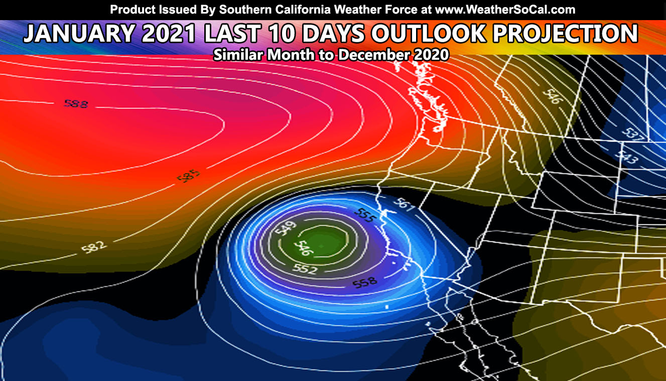
January 2021 is off to a dry start, with systems hitting well to the north of the region, a reason you see all these high clouds down in our region. Long-range models are not handling the weather pattern correctly at all so we have to rely on teleconnections once again like I did when I called on the end of December system in the long-range. Values indicate that we will remain like this up until the last 10 days of this month. Similar to December, the last 10 days would be when the atmosphere responds in a way to bring storms down from the Gulf of Alaska. We are in a 3-4 four week pattern for storms for the next month or so. The winter pattern is locked in place.
As we move into February and March, the solar angle into the North Pole will allow the jet stream to unlock itself from the current pattern and move around erratically. Between that, on its way to the Summer lock, is when we will see the best chance at the most rainfall into Southern California. An erratic pre-summer pattern jet stream has done this before to us. Remember my forecast stated that we looked like a 1991-1992 pattern? December was similar in an atmospheric state as 1991 was with a single system into the region causing high snowfall amounts and higher than forecast rainfall. If the event pattern is like 1991, February and March 1992 delivered a lot of precipitation to our area. This is what I am banking on… the erratic jet stream to move the blocking west and create storms that pound us. On the other hand, if you’re in the flood risk zones, this will be a stressful couple of months coming up.
This is the end of the article for forecasts. Read on for important office information and changes. Something I cannot control, because Facebook did it to you all. Micro-climate alert groups are now over. If you want micro-climate alerts for your very region from me like you used to in those groups, read on as I’m inviting the premium members to my home (website) and Facebook will NOT be in control of you receiving them.
CLICK HERE TO READ THAT IMPORTANT MESSAGE AND ACT SOON BEFORE FACEBOOK KICKS SCWF OFF COMPLETELY –
SCWF is on MeWe and about to be on Gab – https://mewe.com/p/southerncaliforniaweatherforce
Join Southern California Weather Force main Facebook Page by clicking here for future updates if you like what you are reading or seeing below!
MICRO-CLIMATE ALERTS DELIVERED BY EMAIL, FULL MEMBER SECTION WITH INTERACTION DURING EVENTS, ZOOM IN MODELS TO YOUR HOUSE/BUSINESS YOU CONTROL, AND MORE …
CLICK TO JOIN THIS WEBSITE AS A PREMIUM MEMBER
Reading for another state? Join my national page – https://www.facebook.com/nwfweather/
FACEBOOK PAGES TO JOIN!
SOUTHERN CALIFORNIA WEATHER FORCE MAIN: Southern California Weather Force Office Main Page
INSTAGRAM, TWITTER, and NOW MEWE ACCOUNTS TO JOIN!
Instagram – https://www.instagram.com/socalweatherforce/
Twitter – https://twitter.com/SCweatherforce
MeWe – https://mewe.com/p/southerncaliforniaweatherforce