Southern California Weather Force has issued a Thunderstorm Watch for organized storms stretching from the Santa Clarita Valley through to the Banning Pass along the Los Angeles and San Bernardino Mountains, pushing south into the Basin and Valley areas, including the heart of the Inland Empire for Friday afternoon and evening so read on for details …
Join Southern California Weather Force main Facebook Page by clicking here for future updates if you like what you are reading or seeing below!
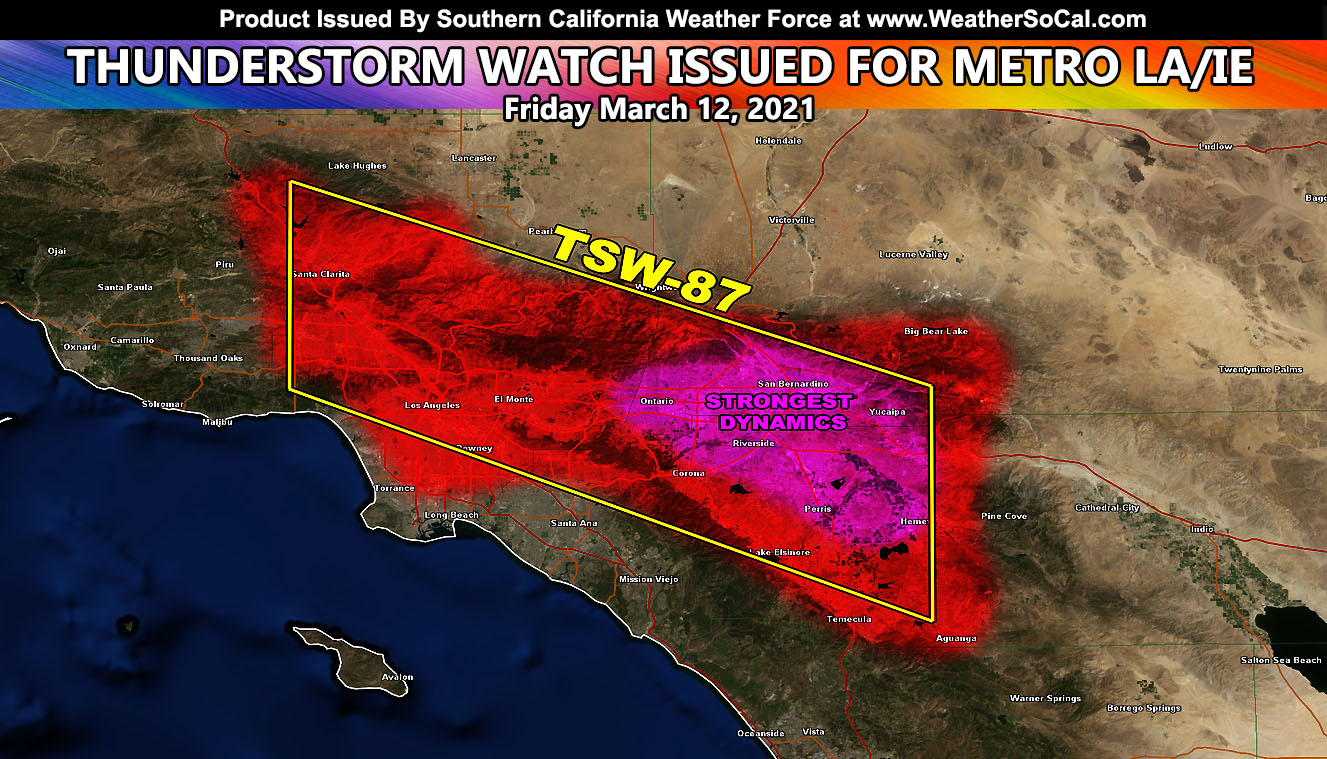
Thunderstorm Watch 87 (TSW-87) went out just before 5:00 am over the custom e-mail alert system for SCWF members. You can see that style by clicking here.
North to south flow above clear skies will work with a convergence zone stretching from the SCV to Banning, along the entire length of the 210 and 10 freeways west to east. This convergence zone in the mountain areas will work with the north to south flow and push off over the later afternoon and evening hours. The strongest dynamics look to exist from Ontario to Redlands in a strong thunderstorm line that will push southeast through the area.
Outskirt activity is likely in the SCV/SFV,, LA Basin and even as far south as Northern Orange County, but the main dynamics will be from Ontario to Redlands southward into the entire Inland Empire.
Snow-levels will afford the chance that Yucaipa, Cherry Valley, and Beaumont will see snowfall with it and that means thundersnow for the mountains …
Areas that could have thunderstorms as well that are not in the watch include the Fallbrook areas … The north flow will also bring the chance of thunderstorm activity to the Ventura Basin/Coast as they come off the mountains … I will NOTE that any cell that pushes near Ventura and offshore will run into some stronger onshore flow, which can bring the risk of waterspouts between there and the Channel Islands. If any photographers are in Ventura, sometime around 4 pm or so would be your shot in that area.
Other areas of focus will be the Kern and Los Angeles Desert areas from the north flow bringing activity in … and the Desert Center zones along I-10 for pop-up isolated storm activity.
Given the flow, I would not be surprised to see a bit of snow in the Morongo Basin, including Joshua Tree National Park to the Yucca Valley grade …
Southern California Weather Force will be closed from March 12th to March 15th. You also can take that time to appreciate the service when you need it and see what it is like without it for a system moving over on Monday.
DENVER 2 FT OF SNOW – Click here to read that one on my National Weather page.
SCWF is on MeWe – https://mewe.com/p/southerncaliforniaweatherforce
MICRO-CLIMATE ALERTS DELIVERED BY EMAIL, FULL MEMBER SECTION WITH INTERACTION DURING EVENTS, ZOOM IN MODELS TO YOUR HOUSE/BUSINESS YOU CONTROL, AND MORE …
CLICK TO JOIN THIS WEBSITE AS A PREMIUM MEMBER
FACEBOOK PAGES TO JOIN!
SOUTHERN CALIFORNIA WEATHER FORCE MAIN: Southern California Weather Force Office Main Page
SOUTHERN CALIFORNIA WEATHER FORCE METEOROLOGIST: – Just my public figure page that isn’t as large so maybe you can reach me better at times.
INSTAGRAM, TWITTER, and NOW MEWE ACCOUNTS TO JOIN!
Instagram – https://www.instagram.com/socalweatherforce/
Twitter – https://twitter.com/SCweatherforce