A magnitude 4.0 jolted the Los Angeles Basin on Monday morning, proceeded by a foreshock 30 minutes prior on the Newport-Inglewood Fault, part of a larger system, the San Andreas Fault. Read on for details …
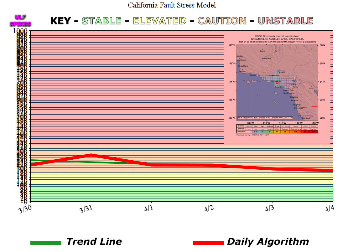
At 4:44 am, April 5, 2021, a magnitude 4.0 jolted the Los Angeles area. It was felt as far as the Inland Empire. Alarms did go off here at the Southern California Weather Force office in Corona. Earthquake charts indicated a slight spike on March 30th, however, it was not an alarming spike. The charts usually have nominal 3s and 4s with those tiny spikes beforehand. We had a 3-mag in Huntington Park on April 1st, almost the same area as this morning’s jolt. At 4:15 am, 30 minutes before the 4.0, a 3.3-magnitude jolted the area. This was probably the foreshock to the 4.0, which means if we don’t see anything in the next few hours, this was probably the mainshock as a full aftershock sequence is happening right now after it, but a 4.0 in the basin could easily affect nearby fault-zones so within the next several days the area should remain on alert in-case a larger one nearby hits, which includes Los Angeles, Orange, Inland Empire, Ventura, San Diego, and the High Desert and mountain areas.
Judging by the aftershock sequence, the fault responsible looks to be the Newport-Inglewood Fault. The Newport–Inglewood Fault is a right-lateral strike-slip fault in Southern California. The fault extends for 47 miles (76 km) from Culver City southeast through Inglewood and other coastal communities to Newport Beach at which point the fault extends east-southeast into the Pacific Ocean where it is known as the Rose Canyon Fault. The fault can be inferred on the Earth’s surface as passing along and through a line of hills extending from Signal Hill to Culver City. The fault has a slip rate of approximately 0.6 millimeter/year (0.02 in/year) and is predicted to be capable of a 6.0–7.4 magnitude earthquake on the moment magnitude scale. A 2017 study concluded that, together, the Newport–Inglewood Fault and Rose Canyon Fault could produce an earthquake of 7.3 or 7.4 magnitudes.
The Newport–Inglewood Fault is part of the larger system of right-lateral strike-slip faults, most prominently the San Andreas Fault, which comprises the transform zone which separates the North American tectonic plate from the Pacific Plate. The irregular hills which occur along the fault trace are a result of the deformation of the sedimentary rocks by the faulting; some of the earliest petroleum production in California tap reservoirs formed by the deformation.
SCWF is on MeWe – https://mewe.com/p/southerncaliforniaweatherforce
MICRO-CLIMATE ALERTS DELIVERED BY EMAIL, FULL MEMBER SECTION WITH INTERACTION DURING EVENTS, ZOOM IN MODELS TO YOUR HOUSE/BUSINESS YOU CONTROL, AND MORE …
CLICK TO JOIN THIS WEBSITE AS A PREMIUM MEMBER
FACEBOOK PAGES TO JOIN!
SOUTHERN CALIFORNIA WEATHER FORCE MAIN: Southern California Weather Force Office Main Page
SOUTHERN CALIFORNIA WEATHER FORCE METEOROLOGIST: – Just my public figure page that isn’t as large so maybe you can reach me better at times.
NATIONAL WEATHER FORCE – Join my NATIONAL page for higher-end events like flood, tornado, hurricanes, and more –
INSTAGRAM, TWITTER, and NOW MEWE ACCOUNTS TO JOIN!
Instagram – https://www.instagram.com/socalweatherforce/
Twitter – https://twitter.com/SCweatherforce