
A mixed back of heavy mountain snow, gusty winds, thunderstorms, and spotty showers will hit Southern California today. Heck some of you won’t even see a thing so you have to pay close attention this forecast so read on for details.
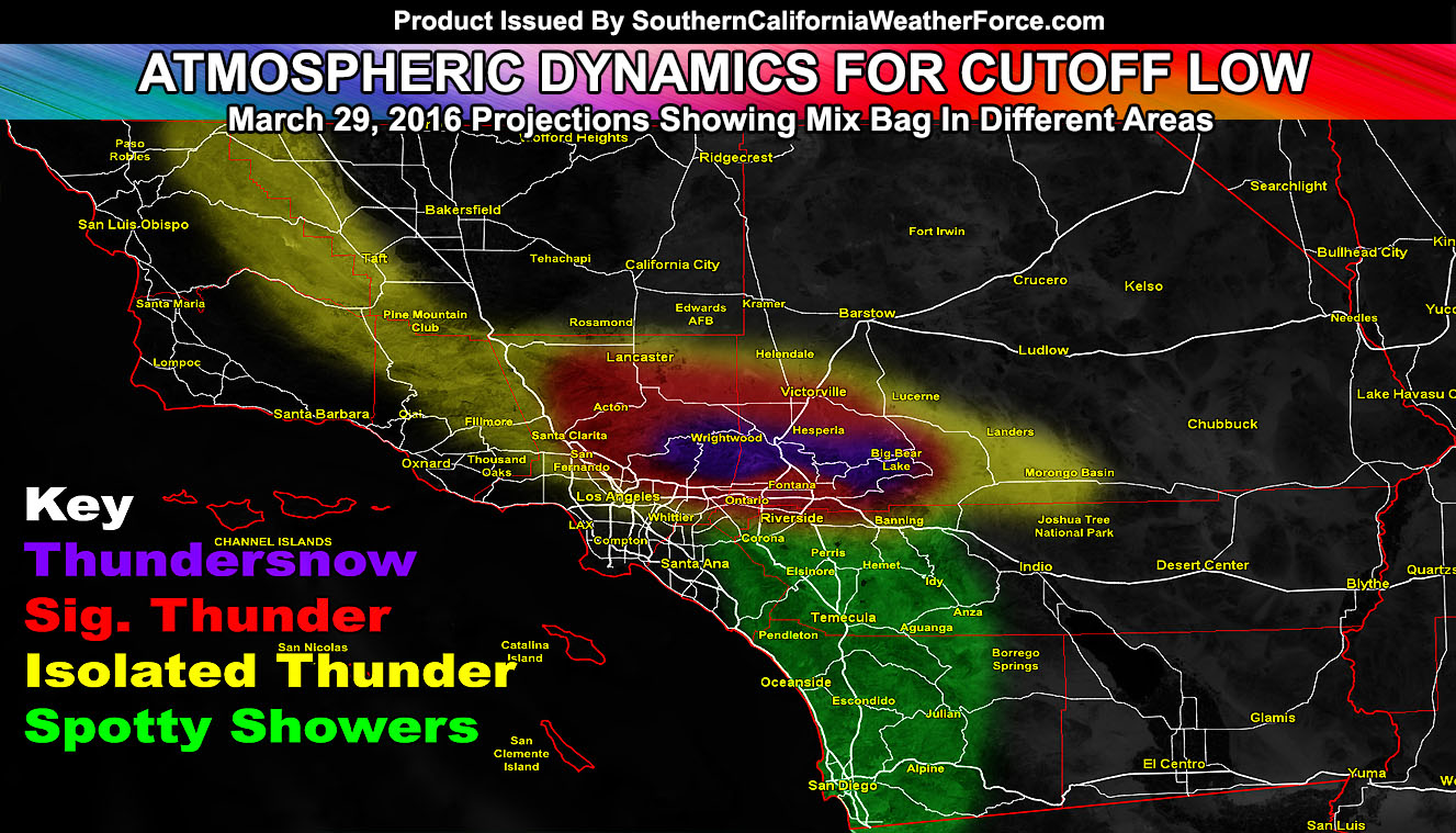
A disturbance is meandering around Southern California through at least Wednesday, however let’s focus first on the thunderstorm activity for today. The activity will form along the trough axis and upper divergent zone swinging through this afternoon and through this evening. The area of lift will pop isolated thunderstorms at the Kern and San Luis Obispo border zones, east southeast into the Pine Mountain Club area. Heavier thunderstorms will focus on the Los Angeles and San Bernardino County Mountains where the most instability and lift will be present.
Given this, mid-level moisture will push these off to the south into the Northern Los Angeles and Inland Empire valley areas, with a cutoff somewhere along the 60 or 10 freeway where south of that shouldn’t see anything .. north of that should .. even within the 10 mile rule I give it and thus the Southern California Weather Force THUNDERSTORM WATCH is in full effect for the areas .. including the Southern High Desert Metros from the Antelope Valley east through Lucerne Valley and the Victor and Apple Valley metros in between so expecting activity in those areas.
Now because the snow level will be below 5,000 FT. thunderstorm activity will bring heavy snowfall to the mountain zones, especially the San Bernardino Mountains and over 6 inches or higher snowfall totals will be expected along with rapid snowfall rates of two to three inches per hour under the heavier storms. This is a dangerous scenario for those who do not read this forecast and know what is coming.
Spotty showers with the onshore flow will continue to develop through the evening/night hours for some metros of the LA, OC, San Diego, and Inland Empire zones … but for the most part the OC and San Diego Metros would only see that risk … thunderstorm risk remains further north.
If a strong thunderstorm forms over the LA Basin/Valleys … rainfall from it will be custom measured and added to the SCWF Official Rainfall Totals. I have a certain way to measure LA Rainfall and that is not just at the USC Campus … it combines the Campus, Pasadena, and Santa Clarita and does an average between them to get the official number and we are not far from making it slightly above average for March.
Through Wednesday, inland areas will continue the risk for activity.
Keep in mind if you are in the San Luis Obispo, Santa Barbara, Los Angeles, Northwest Orange County Coastal zones you will NOT see a thing from this event through Wednesday. You will be wondering where all these storm reports are coming from while your area is high and dry.