
A ridge over the area now is keeping temperatures up inland and nice weather along the coast. As this weekend approaches, a trough coming out of Western Canada would drop into California with a possible positioning for shower, thunderstorm, and mountain snow activity. Read on …
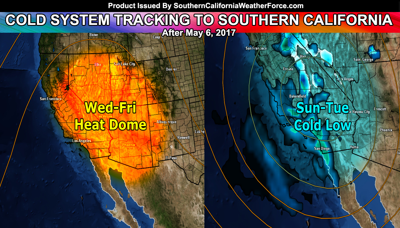
Hot day out today as a ridge of high pressure has built over the region. This maximizes on Wednesday and Thursday over our region. The Southern California Weather Force Heat Advisory is in effect through the end of the week for our low desert areas and the Kern County Valley zones, including Bakersfield, where temperatures will be well over 100F … no wonder they call it ‘bake’
As Saturday comes along the upper level low will be approaching the area and temperatures will knock down with increased onshore winds. On Saturday, a surface low over Las Vegas, Nevada will bring strong gradients into the region. These gradients will make for a strong onshore flow … and High Wind products will be needed for the mountain and desert areas … with possible advisories along our coastal zones with that strong west wind.
LIKE US ON FACEBOOK for updates! Click Here and join thousands …
Once Sunday hits, the upper level low will finally have entered the region. Since it is a cutoff low it will highly depend on your location as to the location to the center of the low itself. If the low goes too far west then most of the precipitation will miss the forecast region. However, if the upper low goes directly over the region, upper level divergence within it could bring a thunderstorm risk to the Los Angeles/Inland Empire surrounding regions, into some of the deserts as well.
Snow level hovering around 6,000 FT would bring mountain snowfall … and as stated before it will be hit and miss so some mountain areas would see a good amount of snow while others would see less. As of now I’m going to keep the track moving directly over the forecast area so monitoring will continue here at the office through the week.
My High Wind Watch product will go out tomorrow for the mountain/desert areas … over the alert system I have for this service.
The upper level low will meander around for a few days, each day having a risk of precipitation with it. After it moves off we will dry once again
Members, Click Here To Enter Your Member Section for precip maps …