
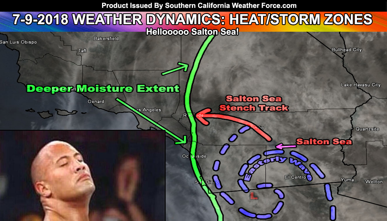
Been getting messages all morning about what that rotten egg smell is. That is the Salton Sea! I know it is many miles away, even from the Inland Empire, but that is what it is due to thunderstorms overnight in the area. More on this and the rest of today by reading on.
Last night I issued a Weather Advisory as storms from Arizona were still 200 miles from Imperial County. They were developing even at night so this meant they were being fed of mid-level instability and an easterly wave, which is highly visible on satellite as a spiral structure might I add.
These storms surged into Imperial Valley early this morning and sent outflow (blast of wind) northwest through the Salton Sea and into the Coachella Valley. Because the winds made it through the Banning Pass (reverse flow) and into the Inland Empire they brought the stench of the Salton Sea with it. So that is what you are smelling out there … ewwwww –
Now for today. Monitoring the mid-upper level cloud deck carefully. Even with the cloud cover the moisture in the area is producing high instability numbers. But.. further monitoring most be done in the high/low deserts and the San Bernardino, Riverside, and San Diego Mountains just in-case something pops under the cloud deck. Should something pop the flow is a bit quick out of the east-northeast today so anything forming in the Riverside Mountains would hit Hemet and Perris to Temecula and anything forming over the Forest Falls area would go into Yucaipa and Redlands.
There is a capping inversion (haze) in most of the Inland Empire today and this would weaken and stop the storm flow as it moves further west. My thunderstorm model was updated in the member section and this is IF we see the cloud-deck thin out enough to get those storms moving. Today has a bunch of probabilities due to the debris clouds.
Feel that overnight into tomorrow has a better chance of activity moving into the Inland areas east of Downtown Los Angeles with less of today’s cloud cover and more dynamics.
Hot/Humid conditions remain for the region … nice at the coast but humid (as always I would say) –
Ongoing Text Ad: Furthermore we parted with our main summer-time advertiser and will need Summer help each year.. but you made it possible! If you are still interested (and I had many asking me how they can pitch in for this) in doing addon and upgrade help you can donate to SCWF in just a couple clicks by CLICKING HERE. Maybe we can get the video green-screen forecast software back!. I do appreciate all the help, especially making the goal to remain operational through the Summer. We are now complete on the goal keep operations this Summer without an advertiser. Thank you everyone who has helped. At this point it is about upgrades/addons as the server operations are now paid for.
EMAIL ALERTS? Many micro-climate zones to choose from to get custom alerts from thunderstorm, wind, flood, surf, heat, cold, storm, and much more with the premium e-mail alert system, the most advanced zone alert system in Southern California – Click Here To Join!
SOUTHERN CALIFORNIA ONLY: if it does not say “Liked” LIKE The Page Below and join thousands of informed weather forecast viewers in our region for more of the updates! noticeable
BEHIND THE SCENES FORECASTS/UPDATE PAGE: if it does not say “Liked” LIKE The Page Below and join thousands of informed weather forecast viewers in our region for more of the updates! noticeable