
Back on November 29th I issued a forecast for cold systems to return during the Christmas period, or before the month of December is over. This was another long range forecast that cannot be seen anywhere but Southern California Weather Force. This will chalk another success in the long range ability and this pattern is now not an what if, but is certain to happen. I’ve opened the free trial for e-mail alerts so you can sign-up, pick your zones, and see how it works for subscribers of the micro-climate system. When the storms near or articles/alerts are released you will get them delivered without having to wait or search for it on social media. Everything is custom at SCWF and you won’t find anything like it so take the free trial offer to test the system out yourself … Since this pattern was called ahead of sources, this is officially a Martin Storm Pattern and Southern California Weather Force is your official source for information pertaining before and during the storm events. It will be a busy period between December 22nd through New Years so keep it to SCWF whether by the free trial offered in this article, facebook pages, micro-climate groups on FB, twitter, instagram, what have you so read on for details or grab the trial …
Join Southern California Weather Force main Facebook Page for future updates!
EMAIL ALERTS: Grab a FREE-TRIAL lasting till December 31st to get these article updates and micro-climate alerts on zones YOU set in your control panel
CLICK HERE FOR THE TRIAL
The article from November 29th (Click Here) stated this pattern would return and we will see it returning for sure. The best details I can give is the start of the pattern will bring showers to Vandenberg AFB zones northward to San Luis Obispo County later Tuesday into Tuesday night. This will miss the area east of those zones so we will be dry for the week across Los Angeles.
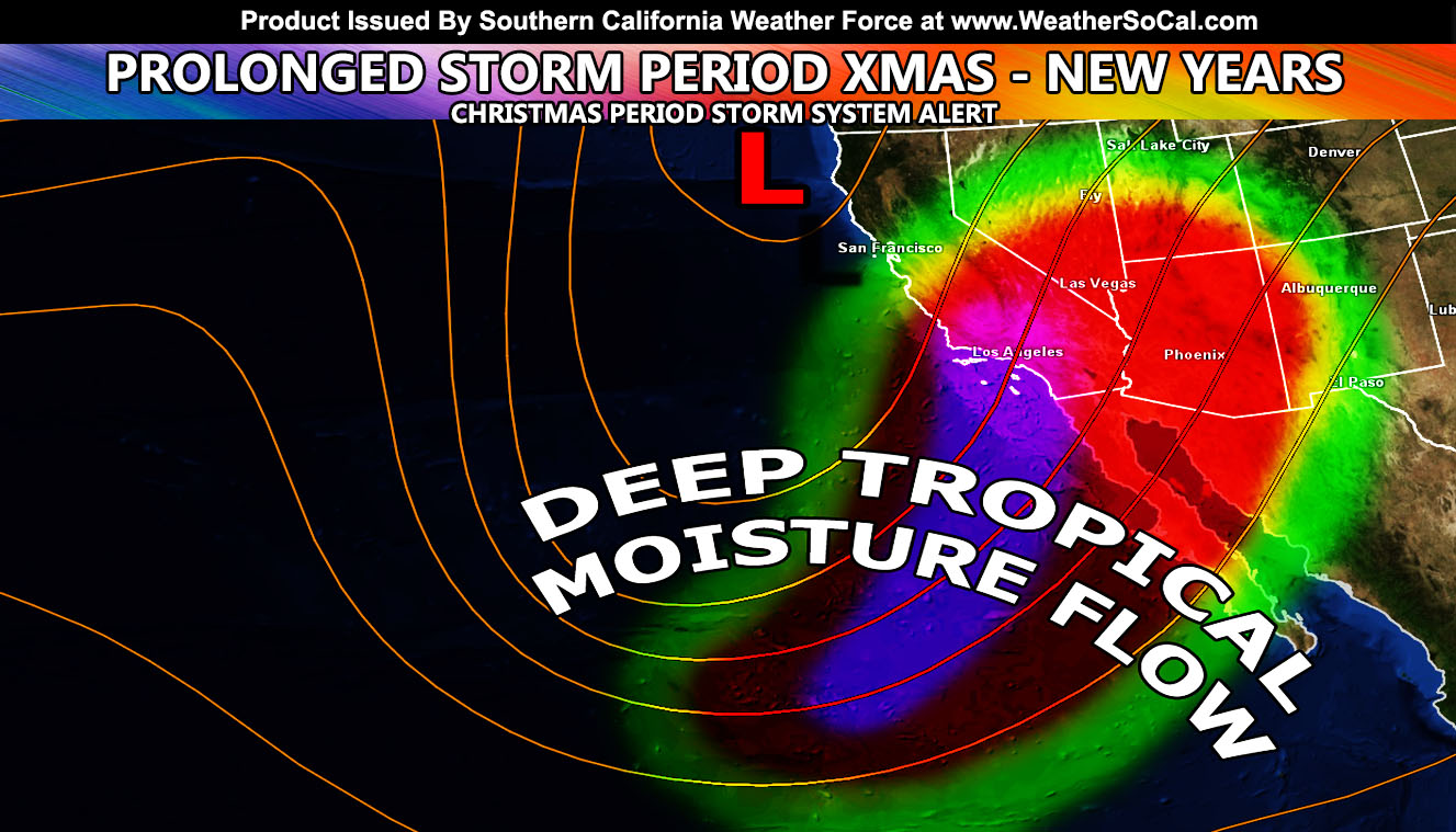
However, by later Sunday we will see the start of what will be a very active storm pattern in Southern California that will last from the 22nd of December and could very well last with rain in the forecast for over a week through to New Years Day. This is a very prolonged period of rain chances. Since we are talking about the Christmas period, the focus will be on there. I do not see anything to stop storm chances on Christmas Eve through Christmas Day. It is a very active pattern and numbers this far out are very wild. One of these systems will have arctic air entrained into it and we will be looking at mountain pass closing snow-levels and amounts for the Gorman/Tehachapi/Cajon Pass areas. If you are planning on traveling you must either get the free trial for my latest alerts (click here) OR get on my Main Facebook Page (click here). I will definitely be taking care of everything on this prolonged period of stormy weather.
The pattern is telling me it will start of with high snow-levels a few days before Christmas and somewhere around the 23rd or 24th we will see the levels drop considerably with the arctic air intrusion and the storms after it would be all resort level producers. Remember I told you on November 29th to make your plans at a mountain resort for Christmas if that is what you wanted to do for snow? Well you have your official answer to have a good time… but be safe.
We could also see HIGH DESERT SNOW with this as well.
There are indications of a shutdown in early January with storms missing to the northeast once again like what is happening now with the Santa Ana Conditions. 9-13″ of rain is still in my forecast for Los Angeles for the season ending May so while we do have these storm patterns, they will be far in-between and not as frequent.
NOTE: ALL Articles AND Videos posted on Southern California Weather Force main Facebook Page are charity events. Anyone sharing will be entered into a list and one person will be randomly selected to get cash for causes. This started on in October 2019 and SCWF has donated $1883.24 to date of this article and counting. … So share away.. the more shares on Facebook, the more help can be done for the community and it costs you nothing just like a lottery ticket. October 2019’s winner was Jessica J Dominguez, and she has claimed the prize. Are you next? – Check the latest amount to win by CLICKING HERE – Remember… that number is going to climb before the contest closes!
MICRO-CLIMATE ALERT FACEBOOK GROUPS: Find yours today!
Click here to join
As always, stay tuned to official forecasts from Southern California Weather Force for updates …
For The Main Weather Facebook Page Click Here and Join.
End Article
FACEBOOK PAGES TO JOIN!
SOUTHERN CALIFORNIA WEATHER FORCE MAIN: Southern California Weather Force Office Main Page
BEHIND THE SCENES FORECASTS/UPDATE PAGE: Southern California Weather Force Meteorologist Page
FOR THE CALIFORNIA FAULT STRESS MODEL PAGE: For SCWF official updates to the California Fault Stress Model and more!
“PONDER THIS” SCIENCE ADVENTURE SHOW: A science adventure show developed here at Southern California Weather Force that is a fun ride! It is NOT active during the weather event season.
INSTAGRAM AND TWITTER ACCOUNTS TO JOIN!
Instagram – https://www.instagram.com/socalweatherforce/
Twitter – https://twitter.com/SCweatherforce