
Southern California Weather Force has issued a Special Weather Statement for Monday, March 18th, 2024, for the following areas:
Zones Issued: Los Angeles, Orange, San Diego County … The Inland Empire … Surrounding Mountain areas … Morongo Basin to Coachella Valley …
The earlier issued alert for Saturday was miscalculated so I apologize on that. It was removed for that reason of error. The timing was wrong. Monday will be what Saturday’s alert should have been and what I calculated such, so we’ll go with that.
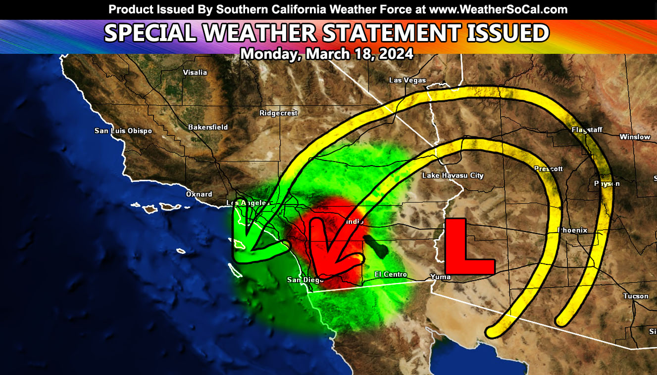
The cutoff low that has kept this odd weather for days is going to move west, aka retrograde tomorrow (Monday). As it places itself on the California and Arizona border, the north flow around it will still bring moisture around. As it is closer, the instability will be stronger near the center of the dynamics, and thus we will have the dynamics for shower and thunderstorm development. I will wait until the morning to finalize the zones, but here is what I have.
The graphic in this shows a green-shaded zone and a small, red-shaded zone. This zone is where the dynamics will be. However, the center of such in the red-shaded will run from Coachella Valley, Banning, Hemet to Temecula, and into Northern and Central San Diego County from what I can calculate. It does not mean that outside this zone that you will not see a thing, but you are not a focus spot for a higher chance of this hitting.
Los Angeles: You will not get a micro-climate notification for this article, simply because you are not the center of the main focus spots, and the population is too large for such an isolated event there.
Chances of this will be high confidence in the graphic, but again, I will report again in the morning for the final, which should not change.
LONG RANGE: As stated, days on days ago, between March 20th and the end of the month will have another storm pattern. This looks to happen near the center of that, around the 24th or so for the start. This is a Raiden Storm Pattern.
A Raiden Storm Pattern means a storm pattern that was predicted before any other model, person, or service did and bears the name of the one that predicted it so that history will know such.
Stay tuned to Southern California Weather Force for updates to this, or any other future forecasts …
– Raiden Storm –
https://www.southerncaliforniaweatherforce.com
Master General Meteorologist – is a consulting meteorologist for over 50 companies, including energy, agriculture, aviation, marine, leisure, and many more areas. He has certs from Mississippi State for broadcast met and Penn State forecasting certs MET 101, 241, 341 and 361 as a meteorologist, but before then was completely self-taught, barely learning a thing from the schools that he did not already know.
Both short and long-range is very important to know in those jobs so you can bet on accuracy here. He is versed in fields like Western USA, Tornadoes, Floods, Hurricanes, High Winds, Fire Behavior, Snow and Blizzards, Short Range, Long Range, Seasonal, and Life-Threatening decisions with over 25 years’ experience, out forecasting all weather services available today with lead-time and precision, which makes him a focus of ridicule and envy.
NOTE: Alerts are posted on here, be it a tornado watch, etc, and these alerts are issued from this office and nowhere else. At times, which is often, you will see an alert forecast posted on here that you do not see elsewhere.