Hurricane Bud is curving into Mexico later this week and the associated moisture will stream into the Southwestern United States. A cutoff low will snap through the area between the weekend and early this next week for continued cooler than normal temperatures. Read on for details, including the rest of the month and a short look into July.
So far June 2018 has been below average in temperatures across the metro areas with average in the high desert and slightly above average in the lower deserts, which was exactly what was on forecast in the June 2018 forecast article (click here to read that).
First, before I go into this .. yes I’ve been quiet on my personal profile as I’ll be able to post again on June 2nd. Furthermore we parted with our main summer-time advertiser and will need help from viewers/readers this Summer. So if you are interested in helping you can donate to SCWF in just a couple clicks by CLICKING HERE. I do appreciate all the help to make it through this Summer Monsoon Season. We approaching now 1/2 to the goal to keep operations this Summer without an advertiser.
With us approaching the middle of June we have yet to see a metro heatwave due to the consistent trough off the coast that has developed as a result of the ridging further east. This trough is keeping the onshore flow in progress and thus the colder than normal temperatures. At the same time the southerly flow is making the lower deserts hot.
SOUTHERN CALIFORNIA ONLY: if it does not say “Liked” LIKE The Page Below and join thousands of informed weather forecast viewers in our region for more of the updates! noticeable
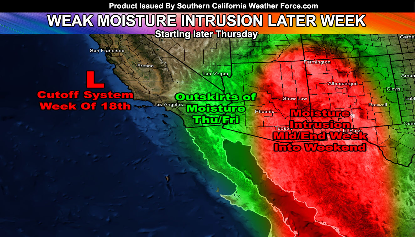
So what will happen is that the hurricane will put a ‘kink’ in the trough sometime Thursday or Thursday night into Friday morning. This should allow for tropical moisture to ‘briefly’ make an appearance into the San Diego, Inland Empire, SBD/RIV/SD Mountain and Desert areas then. The moisture level is rather shallow so a forecast cannot be made indefinite so you will need to keep an eye on future alerts however you receive them from my service. I am not expecting any major moisture event with this as this year’s monsoon should form in July. We have to have a major metro heatwave introduced just before the start of a true monsoon pattern.
As for next week after June 20th, a cutoff low drops into the region and finds a way to snap back west. This could pull some moisture in from Arizona. The exact track is not known at the moment but any deviation would make some of the forecast area see a chance of storm activity. If the cutoff snaps back a bit west then Kern County would be ground zero along with the Barstow/Baker/Needles areas on the eastern side of it.
For now we will remain with cooler than normal temperatures for the metros, slightly elevated in the low deserts, and average in the higher desert areas with the forecast mentioned above. Any interests into Vegas or Phoenix from here in Southern California should monitor latest forecasts.
July is starting to look the same as we head into it but we quickly snap the trough back west during the month, allowing for more monsoonal moisture window chances and some elevated temperatures. Meteorological Summer is considered June, July, and August … not September. So as stated the Summer should be average to below average by the time we are done and June will end up below average in temperatures so that is one month down already, two more to go.
Earthquake fault-stress model here at Southern California Weather Force has bounced back to stable limits, a reason not much statewide is being felt. It’ll be updated daily and freely viewable in the SCWF Member Section.
BEHIND THE SCENES FORECASTS/UPDATE PAGE: if it does not say “Liked” LIKE The Page Below and join thousands of informed weather forecast viewers in our region for more of the updates! noticeable
Things to note are as followed;
- A colder than normal Summer does not mean we won’t have times of a heatwave or two. It means overall it’ll be colder than normal.
- Tornado activity will remain this Summer in the desert and Central/Eastern Inland Empire areas. Thunderstorms elsewhere likely …
- Monsoon Season starts June 15th, however this year will be a mid-start, likely toward or in July.
- To remain active this Summer we are keeping the member section open to the public but as a ‘donation’ for help, by Clicking Here you’ll help this service remain into Summer.