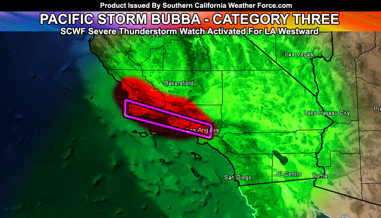
Pacific Storm BUBBA remains a category three out of the 1-6 scale here at Southern California Weather Force. It has prompted me to issue my Severe Thunderstorm Watch for Los Angeles westward and a change for the lower deserts from Imperial to Needles and Desert Center so read on for details …
I’ve issued a Severe Thunderstorm Watch that will replace the flood warning/advisory products in those same zones. The zones are; Southern San Luis Obispo County … Santa Barbara, Ventura, and Los Angeles Metros … Western LA Mountains Highway 14 … Gorman Pass to PMC region of the Kern Mountains …and it reads; As stated in the Flash Flood Watch and Flood Advisory, the region would experience thunderstorm chances. These chances have happened this evening with a round of thunderstorms moving through the alert zones. However, this will only increase overnight and into Wednesday morning as the stronger low level jet dynamics moves in. This will bring about the risk of damaging winds and torrential downpours, along with frequent lightning in the watch area. Pretty much everywhere in the shaded zones will have lightning through tonight … the strongest wind + lightning potential, however, will be very early Wednesday morning, which will make for a messy commute. The activity should remain along the Pacific Coast HIghway and Highway 101, east to I-5 in the SCV/SFV and along the 210/10 in LA County. I do not anticipate an extension to Long Beach for the severity.
Furthermore, I have looked further into the evening values for this system and have caught something to issue a weather advisory in the Imperial Deserts north through the RIV/SBD Eastern desert half. Something I almost missed, but it brings you out of the ‘shaft-zone’. The weather advisory states; Changes in the forecast as the system looks to be tapping into deep instability dynamics overnight tonight and into Wednesday. The ‘warm’ conveyor belt of sub-tropical moisture may just be enough to bring the Eastern Southern California Deserts a chance of precipitation, including the risk of lightning through Wednesday morning, including now through tonight … Instability is expected to develop in the mid-upper levels so don’t be surprised to see some lightning in the advisory zone …
As for the rest of the forecast area around OC/IE … the forecast remains the same, including San Diego. It is very possible that although this system is mainly for Los Angeles westward, the system on March 11th being Pacific Storm Carolina may actually favor Orange County, The Inland Empire, Imperial County, and San Diego County, largely leaving the harder hit areas from Pacific Storm Bubba in weaker dynamics. That is for the 11th of this month or around there. Will update as it gets closer.
The snow level with the Tues/Wed system will be around 7,000 FT with an even colder ‘type’ of system coming by the end of the week with snow-levels between 4,000 – 5,000 FT, meaning this would also affect some of the San Diego County Mountain areas.
After that… we dry up as the storm pattern pulls away from Southern California and we have seasonal temperatures. I am still going to go with a nice NASCAR weekend and I’ll be there of course so I will definitely keep watching the pattern. Confidence is gaining at the time for a good weekend.
As always, stay tuned to Southern California Weather Force for further details. Look at the links below for help, including the ‘Optional’ link if you want to see the flood/rain risk maps on the main SCWF page. Everything is updated accordingly before an event.
OPTIONAL: Southern California Weather Force main page now has models, agendas, the alert map, and other things updated during storm events. You can bookmark the main site and check back during an event for the latest updates.
Click here to view the main page
EMAIL ALERTS: It pays for itself in one storm system. A very affordable e-mail alert system that only gives you SCWF weather alerts in YOUR micro-climate area.
Click here to join
MICRO-CLIMATE ALERT FACEBOOK GROUPS: Find yours today!
Click here to join
SOUTHERN CALIFORNIA ONLY: if it does not say “Liked” LIKE The Page Below and join thousands of informed weather forecast viewers in our region for more of the updates! noticeable
BEHIND THE SCENES FORECASTS/UPDATE PAGE: if it does not say “Liked” LIKE The Page Below and join thousands of informed weather forecast viewers in our region for more of the updates! noticeable